Fur seals are any of nine species of pinnipeds belonging to the subfamily Arctocephalinae in the family Otariidae. They are much more closely related to sea lions than true seals, and share with them external ears (pinnae), relatively long and muscular foreflippers, and the ability to walk on all fours. They are marked by their dense underfur, which made them a long-time object of commercial hunting. Eight species belong to the genus Arctocephalus and are found primarily in the Southern Hemisphere, while a ninth species also sometimes called fur seal, the Northern fur seal, belongs to a different genus and inhabits the North Pacific. The fur seals in Arctocephalus are more closely related to sea lions than they are to the Northern fur seal, but all three groups are more closely related to each other than they are to true seals.

The Rocky Mountains, also known as the Rockies, are a major mountain range and the largest mountain system in North America. The Rocky Mountains stretch 3,000 miles in straight-line distance from the northernmost part of western Canada, to New Mexico in the southwestern United States. Depending on differing definitions between Canada and the U.S., its northern terminus is located either in northern British Columbia's Terminal Range south of the Liard River and east of the Trench, or in the northeastern foothills of the Brooks Range/British Mountains that face the Beaufort Sea coasts between the Canning River and the Firth River across the Alaska-Yukon border. Its southernmost point is near the Albuquerque area adjacent to the Rio Grande rift and north of the Sandia–Manzano Mountain Range. Being the easternmost portion of the North American Cordillera, the Rockies are distinct from the tectonically younger Cascade Range and Sierra Nevada, which both lie farther to its west.

The Canadian Rockies or Canadian Rocky Mountains, comprising both the Alberta Rockies and the British Columbian Rockies, is the Canadian segment of the North American Rocky Mountains. It is the easternmost part of the Canadian Cordillera, which is the northern segment of the North American Cordillera, the expansive system of interconnected mountain ranges between the Interior Plains and the Pacific Coast that runs northwest–southeast from central Alaska to the Isthmus of Tehuantepec in Mexico.
The Travers River is in the South Island of New Zealand.

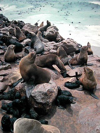
Cape Foulwind is a headland on the West Coast of the South Island of New Zealand, overlooking the Tasman Sea. It is located 11 kilometres (6.8 mi) west of the town of Westport. There is a lighthouse located on a prominent site on the headland. A walkway beginning at the lighthouse carpark traverses the rocky headland to Tauranga Bay and passes close by a colony of New Zealand fur seals. There is limestone quarry in the area, and a cement works operated nearby from 1958 to 2016.

An ice field is a mass of interconnected valley glaciers on a mountain mass with protruding rock ridges or summits. They are often found in the colder climates and higher altitudes of the world where there is sufficient precipitation for them to form. The higher peaks of the underlying mountain rock that protrude through the icefields are known as nunataks. Ice fields are larger than alpine glaciers, but smaller than ice caps and ice sheets. The topography of ice fields is determined by the shape of the surrounding landforms, while ice caps have their own forms overriding underlying shapes.

The pied oystercatcher is a species of oystercatcher. It is a wading bird native to Australia and commonly found on its coastline. The similar South Island pied oystercatcher occurs in New Zealand.

The New Zealand bigeye is a species of marine ray-finned fish, a sweeper from the family Pempheridae. It is endemic to the waters around New Zealand. It inhabitants rocky shores with plentiful overhangs and crevices at depths of from near the surface to 70 metres (230 ft).

The New Zealand eagle ray or Australian eagle ray is an eagle ray of the family Myliobatidae, found in bays, estuaries, and near rocky reefs around New Zealand and southern Australia on the inner continental shelf. It is a common species and the International Union for Conservation of Nature has assessed its conservation status as being of "least concern".
Saltwater Lagoon is a lagoon on the West Coast of New Zealand's South Island.

The Pitt shag, also known as the Pitt Island shag or Featherstone's shag, is a species of bird in the family Phalacrocoracidae. It is endemic to Pitt Island where its natural habitats are open seas and rocky shores. The bird with the color of a dark body, gray chest, yellow eyes and feet can be found in small groups in their breeding habitat or alone within 18 km from their territory searching for food. The species was close to extinction in 1905 but actions of conservation have been done ever since. The Pitt shag is threatened by habitat loss due to predation and climate change causing a decline from 1997 to 2012, but there is a recovery plan by the Department of Conservation.
The Volta Glacier is located in Mount Aspiring National Park in the Southern Alps of the South Island of New Zealand.

The Manakaiaua River is a river of the West Coast Region of New Zealand's South Island. It flows generally northwest from its source on the slopes of Mount Ritchie in the Bare Rocky Range, part of the Southern Alps, reaching the Tasman Sea to the north of Bruce Bay.

Coastal fish, also called inshore fish or neritic fish, inhabit the sea between the shoreline and the edge of the continental shelf. Since the continental shelf is usually less than 200 metres (660 ft) deep, it follows that pelagic coastal fish are generally epipelagic fish, inhabiting the sunlit epipelagic zone. Coastal fish can be contrasted with oceanic fish or offshore fish, which inhabit the deep seas beyond the continental shelves.

The Bay of Plenty is a large bight along the northern coast of New Zealand's North Island. It stretches 260 kilometres (160 mi) from the Coromandel Peninsula in the west to Cape Runaway in the east. Called Te Moana-a-Toi in the Māori language after Toi, an early ancestor, the name 'Bay of Plenty' was bestowed by James Cook in 1769 when he noticed the abundant food supplies at several Māori villages there, in stark contrast to observations he had made earlier in Poverty Bay.

Resplendent Mountain, or Mount Resplendent is a peak in the Canadian Rockies, located at the northern end of Mount Robson Provincial Park in British Columbia, Canada. It is a part of the Rainbow Range, and is a sister peak to the more famous Mount Robson, its nearest neighbour. Together they form a classic panorama seen by travellers from the VIA railway and Highway 16. The mountain was named by Arthur P. Coleman, and Arthur O. Wheeler wrote, "On the east side it is clad from top to bottom in pure white snow, and presents with the sun shining upon it a spectacle of such wonderful brilliance that the aptness of the name became immediately apparent." The first ascent was achieved on the same historic 1911 trip in which Conrad Kain first scouted the climbing routes later to be used on the first ascent of Mount Robson.

The Olivine Ice Plateau is a glacier in the Olivine Wilderness Area and Aspiring National Park in New Zealand's South Island. The plateau is named after the mineral olivine, which is common within the Dun Mountain Ophiolite that underlies the area. The plateau extents to the west over the Forgotten River Col. into the Forgotten River and to the north it merges with the Andy Glacier, which feeds a tributary of the Arawhata River. The Olivine Ice Plateau is one of many glaciers in the region of the Arawhata, Dart / Te Awa Whakatipu, Hollyford / Whakatipu Kā Tuka and Matukituki rivers' headwaters.
Hawea Marine Reserve is a marine reserve covering an area of 411 hectares in Hāwea / Bligh Sound, in Fiordland on New Zealand's South Island. It was established in 2005 and is administered by the Department of Conservation.
Long Island-Kokomohua Marine Reserve is a marine reserve, in the Marlborough Region of New Zealand's South Island. It covers an area of 619 hectares at the entrance to the Queen Charlotte Sound in the Marlborough Sounds. It was the first marine reserve established on the South Island.

Punakaiki Marine Reserve is a marine reserve administered by the Department of Conservation. The reserve includes the area of sea surrounding the pancake rocks and blowholes at Dolomite Point, at Punakaiki on the West Coast Region of New Zealand's South Island. It also includes most of the coastline on the western edge of Paparoa National Park.


