Related Research Articles
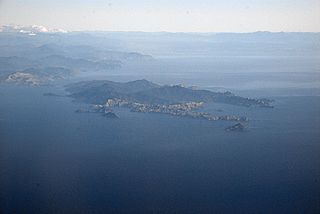
Rangitoto ki te Tonga / D'Urville Island is an island in the Marlborough Sounds along the northern coast of the South Island of New Zealand. It was named after the French explorer Jules Dumont d'Urville. With an area of approximately 58 square miles (150 km2), it is the eighth-largest island of New Zealand, and has around 52 permanent residents. The local authority is the Marlborough District Council.

Raglan is a small beachside town located 48 km west of Hamilton, New Zealand on State Highway 23. It is known for its surfing, and volcanic black sand beaches.

Otorohanga is a north King Country town in the Waikato region in the North Island of New Zealand. It is located 53 kilometres (33 mi) south of Hamilton and 18 kilometres (11 mi) north of Te Kuiti, on the Waipa River. It is a service town for the surrounding dairy-farming district. It is recognised as the "gateway" to the Waitomo Caves and as the "Kiwiana Town" of New Zealand. Until 2007, Otorohanga held a yearly 'Kiwiana Festival.'

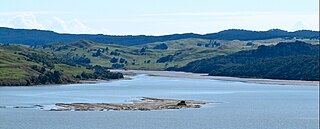
Kawhia Harbour is one of three large natural inlets in the Tasman Sea coast of the Waikato region of New Zealand's North Island. It is located to the south of Raglan Harbour, Ruapuke and Aotea Harbour, 40 kilometres southwest of Hamilton. Kawhia is part of the Otorohanga District Council. It has a high-tide area of 68 km2 (26 sq mi) and a low-tide area of 18 km2 (6.9 sq mi).
Okoroire is a small settlement in the South Waikato District and Waikato Region of New Zealand's North Island, centered around the Okoroire Hot Springs.

The Awanui River is a river in the far north of New Zealand, close to the point at which the Aupouri Peninsula joins the rest of the Northland Peninsula. The Awanui flows first west and then north, for a total of 30 kilometres (19 mi), before flowing into Rangaunu Harbour. The town of Kaitaia is along its banks.
The Mangaotaki River is a river of the southern Waikato Region of New Zealand's North Island. It flows generally southeast from its sources in the coastal Herangi Range to reach the Mokau River 15 kilometres (9 mi) southwest of Piopio.
The Mangapu River is a river of the Waikato Region of New Zealand's North Island. It has its sources in numerous streams which flow generally northwards from the King Country south of Te Kuiti, the longest of which is the Mangaokewa Stream. These streams join to form the Mangapu close to Te Kuiti, and from here the river flows north, passing close to the east of Waitomo Caves, where the Mangapu caves have the largest entrance in the North Island, before flowing into the Waipa River at Otorohanga.
The Oparau River is a river of the Waikato Region of New Zealand's North Island. It flows southwest from its sources in the Pirongia Forest Park and flows into the Kawhia Harbour 5 kilometres (3 mi) east of Kawhia.

The Opotoru River is a river of the Waikato Region of New Zealand's North Island. It flows north, reaching the Raglan Harbour southwest of the town of Raglan. There is no regular monitoring of pollution, but 38 kilometres (24 mi) (31.2%) of the river has been fenced to protect it from farm stock.
The Puhi Puhi River is a river of the Marlborough Region of New Zealand's South Island. It flows southwest, roughly paralleling the Pacific Ocean coast, from its source 12 kilometres (7 mi) west of the mouth of the Clarence River, and reaches its outflow into the Hapuku River 5 kilometres (3 mi) from the latter's mouth at Hapuku. One of the tributaries is the Clinton River.
The Rotokakahi River is a river of the Northland Region of New Zealand's North Island. Its winding course is predominantly southwestward from its origins in the Maungataniwha Range. It reaches the Tasman Sea 25 kilometres (16 mi) south of Kaitaia, and its estuary forms one of the two arms of Whangape Harbour.
The Tawatahi River is a short river of the Waikato Region of New Zealand's North Island. It flows into the northern shore of Raglan Harbour.
Hinuera is a settlement in the Waikato Region of New Zealand's North Island. It is located along State Highway 29, approximately halfway between the cities of Hamilton and Tauranga. It also contains the Hinuera cliffs along State Highway 29.

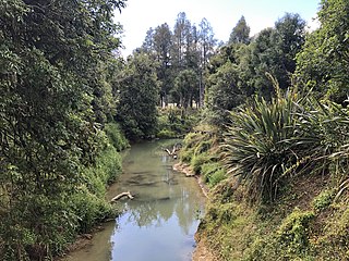
The Awaroa River is a short river in the Waikato District of New Zealand's North Island. It flows east from its source in the dunes near Karioitahi Beach and Lake Puketi, then south from Waiuku joining with the Aka Aka Stream before reaching the Waikato River in its tidal reaches close to Motutieke Island.
Lake Whangape is shallow, supertrophic, lateral and the second largest lake in the lower Waikato River basin. One source said the name translated to 'a large sheet of water', another that it was a chief's name.
Waerenga is the name of a hamlet, 11 km (6.8 mi) east of Te Kauwhata, which is part of a statistical area unit in the Waikato District. Waerenga-a-Hika, near Gisborne has a similar name.
Rotokawa is a rural community in the Taupo District and Waikato Region of New Zealand's North Island.
Oruanui or Ōruanui is a rural community in the Taupo District and Waikato Region of New Zealand's North Island, located northwest of Wairakei on State Highway 1.
Puketotara, or Puketōtara, is a rural community in the Otorohanga District and Waikato Region of New Zealand's North Island.
References
- ↑ "Awaroa River, Waikato - NZ Topo Map". NZ Topo Map. Retrieved 21 June 2016.
- ↑ "Awaroa River, Waikato - NZ Topo Map". NZ Topo Map. Retrieved 21 June 2016.
- ↑ "Place name detail: Awaroa River". New Zealand Gazetteer. Land Information New Zealand . Retrieved 27 November 2009.
- ↑ "Awaroa River, Northland - NZ Topo Map". NZ Topo Map. Retrieved 4 February 2017.
- ↑ "1000 Māori place names". New Zealand Ministry for Culture and Heritage. 6 August 2019.
Coordinates: 35°20′12″S173°14′30″E / 35.336709°S 173.241652°E
| This article about a river in the Northland Region is a stub. You can help Wikipedia by expanding it. |