
Westport is a town in the West Coast region of the South Island of New Zealand. It is on the northern bank and at the mouth of the Buller River, close by the prominent headland of Cape Foulwind. It is connected via State Highway 6 with Greymouth, 100 kilometres (62 mi) to the south, and with Nelson 222 kilometres (138 mi) in the northeast, via the Buller Gorge.

Waimangaroa is a small town located on the West Coast of New Zealand.

The NZR WB class was a class of tank locomotives that operated in New Zealand. Built in 1898 by the Baldwin Locomotive Works, the twelve members of the class entered service during the first five months of 1899. Eight were withdrawn by the end of 1935, while four others survived with new boilers until the mid-1950s.

The Midland line is a 212km section of railway between Rolleston and Greymouth in the South Island of New Zealand. The line features five major bridges, five viaducts and 17 tunnels, the longest of which is the Otira tunnel. It is the route of the popular TranzAlpine passenger train.

The Stillwater Ngākawau Line (SNL), formerly the Stillwater–Westport Line (SWL) and the Ngakawau Branch, is a secondary main line, part of New Zealand's national rail network. It runs between Stillwater and Ngakawau via Westport on the West Coast of the South Island. It was one of the longest construction projects in New Zealand's history, with its first section opened in 1889 but the full line not completed until 1942.
Ngahere is a locality in the Grey District of the West Coast of New Zealand's South Island. The 2013 New Zealand census gave the population of Ngahere and its surrounding area as 363, an increase of 5.2% or 18 people since the 2006 census.
The Rewanui Branch, sometimes referred to as the Rewanui Incline and known as the Point Elizabeth Branch in its early years, was a branch line railway located in the West Coast region of New Zealand's South Island. It branched from the Midland Line near its western terminus in Greymouth and ran up to Rewanui in the Paparoa Ranges. The branch closed in 1985 but the first six kilometres to Runanga remain in operation as part of the Rapahoe Branch.
The Seddonville Branch, later truncated as the Ngakawau Branch, is a branch line railway in the West Coast region of New Zealand's South Island. Construction began in 1874 and it reached its terminus at the Mokihinui Mine just beyond Seddonville in 1895. In 1981 it was closed past Ngakawau and effectively became an extension of the Stillwater–Westport Line, since formalised as the Stillwater Ngakawau Line.

Seddonville is a lightly populated locality on the West Coast of New Zealand's South Island. It is most famous for the historical role it played in New Zealand's coal mining industry.

The Glasgow Range is a mountain range on the northern West Coast of New Zealand's South Island. It is north of the Papahaua Range and its most significant river is the Mōkihinui River.
Summerlea is a lightly populated locality on the West Coast of New Zealand's South Island.
Sergeants Hill is a lightly populated locality in the West Coast region of New Zealand's South Island. It is situated in a rural setting on the eastern outskirts of Westport in the Buller District.
The Conns Creek Branch was a 2.7 kilometre branch line railway in the West Coast region of New Zealand's South Island. It diverged from the Seddonville Branch at Waimangaroa and followed the southern bank of the Waimangaroa River to the line's terminus at Conns Creek at the foot of the Denniston Incline. The line operated from 1877 until 1967 and existed for the sole purpose of conveying coal from mines to the port of Westport.
State Highway 67 (SH 67) is a New Zealand state highway located in the northern parts of the South Island of New Zealand. It is 51.2 km long and connects SH 6 with the settlement of Mokihinui. It used to be 96 kilometres long and ran the entire length of the road to Karamea. The highway and its spur serves the large West Coast town of Westport and lies entirely within the Buller District.

The Ngakawau River is a river of the West Coast Region of New Zealand's South Island. It flows generally northwest, reaching the Tasman Sea at Hector.
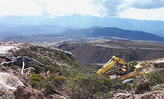
Stockton Mine, on the Stockton Coal Field, is New Zealand's largest opencast mining operation. The entrance to the mine is at the former settlement of Stockton. The mine was operated by Solid Energy in a partnership agreement with Downer Australia. Solid Energy obtained the Stockton Coal Mining Licence (CML) in 1987 for a period of 40 years. In 2016 Talley's, in a joint purchase with Bathurst Resources, bought this and former Solid Energy mines at Rotowaro and Maramarua.

Water pollution is an environmental issue on the West Coast of New Zealand.
Mokihinui is a lightly populated locality on the West Coast of New Zealand's South Island.
The Rockies Incline was an inclined tramway on the West Coast of the South Island of New Zealand that for ten years from 1925 to 1935 brought coal from the Westport Main Coal Company’s mine on the Millerton-Stockton plateau down to the Westport to Seddonville railway line near sea level.

The Charming Creek Tramway was a 9 kilometres (5.6 mi) long private logging and mining railway at Ngakawau in Buller District on the West Coast in New Zealand. It was used from 1903 or 1905 to 1958.
