Ikamatua

Last updated

Ikamatua
town
Ikamatua Hotel.JPG
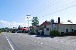
State Highway 7 passing through Ikamatua
New Zealand (location map).svg
Disc Plain red.svg
Ikamatua
Coordinates: 42°16′17.13″S171°41′3.77″E / 42.2714250°S 171.6843806°E / -42.2714250; 171.6843806
Country New Zealand
Region West Coast
Territorial authority Buller District
Electorates West Coast-Tasman
Te Tai Tonga
Time zone UTC+12 (New Zealand Standard Time)
  Summer (DST) UTC+13 (New Zealand Daylight Time)

Ikamatua is a small village on the West Coast of the South Island in New Zealand. Its name translates literally as ika (fish) and matua (mature/parent). It may be a contraction of Te Ika-a-matua, fish of my ancestor. [1]

It is located on the State Highway 7 inland route, 50 kilometres (31 mi) north of Greymouth and 28 kilometres (17 mi) south of Reefton. It has a population of under 200. [2]

In 1946, 4 km north of Ikamatua, the floating Grey River gold dredge dug its way across State Highway 7, and the main Greymouth to Westport railway link, to move into its new mining area in the Blackwater Valley. This was the first and only time that such an event has occurred in New Zealand. [3]

In 1906 Ikamatua had two sawmills, a creamery, a railway station and a school. [4]

Related Research Articles

<span class="mw-page-title-main">West Coast Region</span> Region of New Zealand

The West Coast is a region of New Zealand on the west coast of the South Island. It is administered by the West Coast Regional Council, and is known co-officially as Te Tai Poutini. It comprises the territorial authorities of Buller District, Grey District and Westland District. The principal towns are Westport, Greymouth and Hokitika. The region, one of the more remote areas of the country, is also the most sparsely populated. With a population of just 32,900 people, the West Coast is the least populous region in New Zealand. The population in the region grew by 0.4% over the year to July 2023.

<span class="mw-page-title-main">Jackson Bay</span>

Jackson Bay / Okahu is a gently curving 24-kilometre (15 mi) bay on the southern West Coast of the South Island of New Zealand. It faces the Tasman Sea to the north, and is backed by the Southern Alps. It contains the settlements of Hannahs Clearing, Waiatoto, Neils Beach, and the fishing village of Jackson Bay at its western end. The bay is the southernmost terminus of the West Coast's roads.

<span class="mw-page-title-main">Awarau River</span> River in New Zealand

The Awarau River, usually known as Larry's Creek is located within the South Island of New Zealand. The river is about 27 kilometres (17 mi) long and runs northwest from its headwaters in the Victoria Range to its confluence with the Inangahua River north of Reefton. It also drains part of the Brunner Range and there was a track along that range linking to Lyell by 1901, though none existed in 1874. A track also ran south over Kirwan Hill to the Montgomerie River.

<span class="mw-page-title-main">Greymouth</span> Town in West Coast, New Zealand

Greymouth is the largest town in the West Coast region in the South Island of New Zealand, and the seat of the Grey District Council. The population of the whole Grey District is 14,250, which accounts for 43% of the West Coast's inhabitants. The Greymouth urban area had an estimated population of 8,340. A large proportion of the District, 65%, is part of the Conservation Estate owned and managed by the Department of Conservation making Greymouth a natural centre for walkers and trampers.

<span class="mw-page-title-main">Crushington, New Zealand</span> Place in West Coast, New Zealand

Crushington is a town beside the Inangahua River in the West Coast region of New Zealand.

<span class="mw-page-title-main">Runanga, New Zealand</span> Town in the South Island of New Zealand

Runanga is a small town on the West Coast of the South Island of New Zealand. It is located eight kilometres to the northeast of Greymouth, to the north of the Grey River. Barrytown is 21 kilometres (13 mi) further north. State Highway 6 and the Rapahoe Branch railway run through the town. Runanga was formerly a railway junction, with the steep Rewanui Branch diverging from the Rapahoe line until closure in 1985.

<span class="mw-page-title-main">Inangahua River</span> River in New Zealand

The Inangahua River is located in the north-west of New Zealand’s South Island. It is a major tributary of the Buller River, where it joins at the town of Inangahua Junction.

<span class="mw-page-title-main">Reefton</span> Town in the South Island of New Zealand

Reefton is a small town in the West Coast region of New Zealand, some 80 km northeast of Greymouth, in the Inangahua River valley. Ahaura is 44 km south-west of Reefton, Inangahua Junction is 34 km to the north, Maruia is 63 km to the east, and the Lewis Pass is 66 km to the south-east.

<span class="mw-page-title-main">Inangahua Junction</span> Settlement on the West Coast of the South Island of New Zealand

Inangahua is a small settlement in the northwest of New Zealand's South Island. It consists of three settled areas: Inangahua Junction at the confluence of the Inangahua and Buller Rivers, 34 kilometres (21 mi) north of Reefton and 46 kilometres (29 mi) southeast of Westport; Inangahua Landing, 10 km further up the Inangahua River; and Inangahua township, 2 km east of the Junction. Murchison is 52 kilometres (32 mi) further east. After the 1968 Inangahua Earthquake, most of the inhabitants left the area or shifted to the township, which is now the population centre and known simply as Inangahua.

<span class="mw-page-title-main">Te Matua Ngahere</span> Large individual kauri tree in New Zealand

Te Matua Ngahere is a giant kauri coniferous tree in the Waipoua Forest of Northland Region, New Zealand. The tree's Māori name means "Father of the Forest". Although not as massive or tall as its neighbour Tāne Mahuta, Te Matua Ngahere is stouter, with a girth just over 16 metres (52 ft). It is believed to be the second largest living kauri tree, and to have the biggest girth of any kauri in the country. According to The New Zealand Herald, it has the biggest girth of any tree in New Zealand.

<span class="mw-page-title-main">Brunner, New Zealand</span> Place in West Coast, New Zealand

Brunner, originally called Brunnerton, is a town in the northwest of New Zealand's South Island. It is 12 kilometres (7 mi) east of Greymouth, on the south bank of the Grey River. It is on the Midland Line railway near its junction with the Stillwater–Westport Line (SWL) in neighbouring Stillwater. Passenger trains ceased running along the SWL to Reefton and Westport in 1967, but the TranzAlpine runs the length of the Midland Line from Christchurch to Greymouth and it continues to stop in Brunner.

<span class="mw-page-title-main">Stillwater–Ngākawau Line</span> Railway line in New Zealand

The Stillwater Ngākawau Line (SNL), formerly the Stillwater–Westport Line (SWL) and the Ngakawau Branch, is a secondary main line, part of New Zealand's national rail network. It runs between Stillwater and Ngakawau via Westport on the West Coast of the South Island. It was one of the longest construction projects in New Zealand's history, with its first section, at the south end, opened in 1889, and the beginnings of the Ngākawau Branch, at its Westport end, in 1875. The full line was completed in 1942. The only slower railway projects were Palmerston North to Gisborne, 1872 to 1942, and the Main North Line to Picton, 1872 to 1945.

<span class="mw-page-title-main">Ross Branch (railway line)</span>

The Ross Branch, officially known as the Hokitika Line since 2011, and previously as the Hokitika Industrial Line, is a branch line railway that forms part of New Zealand's national rail network. It is located in the Westland District of the South Island's West Coast region and opened to Hokitika in 1893. A further extension to Ross operated from 1909 until 1980.

<span class="mw-page-title-main">State Highway 7 (New Zealand)</span> Road in New Zealand

State Highway 7 is a major New Zealand state highway. One of the eight national highways, it crosses the Southern Alps to link the West Coast Region with Canterbury and to form a link between the South Island's two longest highways, State Highway 1 and State Highway 6. Distances are measured from east to west with the major junction list going from east to west.

<span class="mw-page-title-main">Paroa, West Coast</span> Settlement in the South Island of New Zealand

Paroa is a settlement on the West Coast of the South Island of New Zealand, just south of Greymouth. State Highway 6 and the Hokitika Branch railway both run through Paroa. This railway was originally a bush tramway that opened to Paroa from Greymouth in 1867 and was extended to Kumara in 1877. It was converted into a railway in 1893, and this time, ran from Paroa to Hokitika rather than Kumara.

<span class="mw-page-title-main">Ahaura</span> Town in the South Island of New Zealand

Ahaura is a town in the West Coast region of New Zealand's South Island, sited where the Ahaura River flows into the Grey River. State Highway 7 and the Stillwater–Ngākawau railway line pass through the town. Greymouth is 34 kilometres (21 mi) to the south-west, and Reefton is 44 kilometres (27 mi) to the north-east.

<span class="mw-page-title-main">Lyell, New Zealand</span> Place in West Coast, New Zealand

Lyell is the site of a historic gold mining town in the Buller Gorge in the South Island of New Zealand. It lies on State Highway 6, 18 km (11 mi) northeast of Inangahua.

Waiuta is the location of a historic mining town on the West Coast of the South Island of New Zealand. It is now abandoned and considered a ghost town. Located 58 km north of Greymouth and 21 km south of Reefton in Ikamatua, New Zealand, it was the site of a gold mine until 1951, when the collapse of the mine made it uneconomic. A number of buildings remain and there are still residents in what remains of the town. Nowadays Waiuta has become a tourist attraction, with few of the original buildings still intact that include the former police station, three cottages and the old barber shop.

The Little Grey River, also known as the Māwheraiti is a river of the West Coast Region of New Zealand. It is a major tributary of the Grey River / Māwheranui which it joins at Ikamatua.

<span class="mw-page-title-main">Blacks Point</span>

Blacks Point is a locality near Reefton on the West Coast of the South Island of New Zealand.

References

  1. Reed, A. W. (1979). The Reed dictionary of New Zealand place names (2002 ed.). Auckland [N.Z.]: Reed. ISBN   0-7900-0761-4. OCLC   49290681.
  2. "Ikamatua" . Retrieved 11 April 2010.
  3. Latham, Darrell (1984). The Golden Reefs: an account of the great days of quartz-mining at Reefton, Waiuta and the Lyell. Christchurch: Pegasus Press. p. 417. ISBN   0908568126.
  4. "The Cyclopedia of New Zealand - Ikamatua". nzetc.victoria.ac.nz. 1906. Retrieved 15 September 2022.