
The Ahaura River is in the South Island of New Zealand. This river drains the western flanks of the Southern Alps and flows into the Grey River.
The Alexander River is on the West Coast of the South Island of New Zealand. It flows into the Upper Grey River.
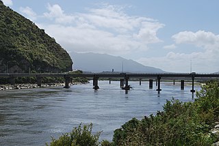
The Grey River / Māwheranui is located in the northwest of the South Island of New Zealand. It rises 12 kilometres southwest of the Lewis Pass in Lake Christabel, one of numerous small lakes on the western side of the Southern Alps, and runs westward for 120 kilometres before draining into the Tasman Sea at Greymouth. Thomas Brunner, who explored the area in the late 1840s, named the river in honour of Sir George Grey, who first served as Governor of New Zealand from 1845 to 1854. The Ngāi Tahu Claims Settlement Act 1998 changed the official name of the river to Grey River / Māwheranui in 1998. The Māori name for the river system and surrounding area is Māwhera, with Māwheranui being distinguished from the northern branch Little Grey River / Māwheraiti.

The Haupiri River is a river of New Zealand. It starts near Mount Dixon in the Kaimata Range of the Southern Alps and flows north-west near to Lake Haupiri, then north-east to join the Ahaura River. The Ahaura joins the Grey River which flows into the Tasman Sea at Greymouth.
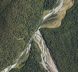
The Rough River, alternatively known as the Otututu River is a river of the West Coast Region of New Zealand's South Island. A major tributary of the Grey River, it flows south from its sources near Mount Uriah in the Paparoa Range 20 kilometres southeast of Charleston, to reach the Grey River to the southwest of the settlement of Ikamatua. The river is currently shown on maps as Otututu (Rough) River, although this orthography is no longer common for New Zealand Rivers.
The Snowy River is a river of the West Coast Region of New Zealand's South Island. It flows generally west from its sources within Victoria Forest Park, and is one of the rivers whose courses mark the edges of the Ikamatua Plain. The Snowy River joins with the Blackwater River 100 metres prior to its junction with the Māwheraiti River two kilometres north of the township of Ikamatua.
The Tass River is a river of the West Coast Region of New Zealand's South Island. It flows predominantly northeast from its origins in the Southern Alps east of Lake Hochstetter, reaching the Upper Grey River close to the southern tip of the Victoria Forest Park.
The Big River is a river in the Grey District, in the West Coast region of New Zealand's South Island. It is a tributary of the Grey River.

The Tyneside Mine was a coal mine on the West Coast of the South Island in New Zealand. The Tyneside Mine was one of several mines situated on the banks of the Grey River, at an area known as "Coal Gorge" between the townships of Stillwater and Taylorville.
The Little Grey River, also known as the Māwheraiti is a river of the West Coast Region of New Zealand. It is a major tributary of the Grey River / Māwheranui which it joins at Ikamatua.

The Arnold River is a river on the West Coast of New Zealand's South Island. It is the outflow of Lake Brunner, which it links with the Grey River at Stillwater. The Arnold River flows northwest for 20 kilometres (12 mi), joining the Grey immediately above the town of Brunner, some 15 kilometres (9 mi) from the Tasman Sea. It is a popular spot for whitewater kayaking and trout fishing.
Grey County was one of the counties of New Zealand in the South Island.
The Robinson River is a river in the West Coast Region of the South Island of New Zealand. It is a tributary of the Upper Grey River and much of the river lies within the Lake Sumner Conservation Park. Rising on the slopes of Mount Boscawen on the main divide about 12 kilometres (7.5 mi) south of the Lewis Pass, the river runs west-southwest along a straight, narrow valley before turning northwest to reach the Upper Grey.

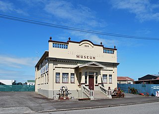
Taylorville is a small town on the banks of the Grey River, It is roughly 10 kilometers from the mouth of the river in Greymouth.
The Greymouth Borough was the borough council covering the urban part of Greymouth, New Zealand between 1868 and 1989, when it became part of Grey District.
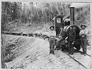
Bell Hill mill tramway was a bush tramway at Bell Hill in the Moana Region of the Grey District on the West Coast of New Zealand. The tramway with a track gauge of 3 ft 6 in was used in the 1910s.

Wallsend is a locality in the West Coast region of New Zealand, located on the south side of the Grey River. It is located opposite Taylorville. The two settlements were connected via a suspension bridge for pedestrians that was known as the Taylorville bridge.
The Brunner Borough was a borough on New Zealand's West Coast from 1887 to 1971. It was formed from an area that belonged to Grey County and, at disestablishment, merged back into Grey County.
The Blackwater River is located in the Buller District of New Zealand. It is the name given to the lower reaches of the Big River, from its junction with the Blackwater Creek to its outflow into the Māwheraiti River. It flows generally westwards for 10 kilometres (6.2 mi) before turning southwards immediately prior to its junction with the Māwheraiti 2.5 kilometres (1.6 mi) north of the township of Ikamatua. It joins with the similar-sized Snowy River 100 metres (330 ft) before its junction with the Māwheraiti.
The Tūtaekurī River starts near the Hope Pass, in the Southern Alps and flows north-west to join the Ahaura River. The Ahaura joins the Grey River which flows to the Tasman Sea at Greymouth. Tūtaekurī River has been its official name since 21 June 2019. Tūtae kurī is a grass with the latin name agropyron multiflorum.
