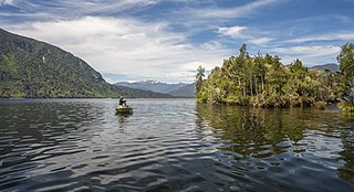
Lake Brunner is the largest lake in the West Coast Region of New Zealand, located 31 km (19 mi) southeast of Greymouth. The main settlement, Moana, is on its northern shore. It is an important settlement and waystation for local Māori. The first Europeans in the area were loggers, and sawmills were an important early industry. Being several kilometres inland from the coast road, it is less frequently visited by tourists than many of the West Coast's scenic highlights, but it is becoming increasingly popular, in part due to its reputation for fishing.

The Clarence River is a major river which flows through the Kaikōura Ranges in the northeast of New Zealand's South Island. At roughly 209 kilometres (130 mi) long, it is the longest river in Canterbury and the eighth longest in New Zealand.

The Manawatū River is a major river of the lower North Island of New Zealand. The river flows from the Ruahine Ranges, through both the Manawatū Gorge and the city of Palmerston North, and across the Manawatū Plains to the Tasman Sea at Foxton.

Inchbonnie is a rural locality in the West Coast region of the South Island of New Zealand. It is located on the north bank of the Taramakau River and is just to the south of Lake Poerua. "Inchbonnie" is a hybrid of Lowland Scots, bonnie meaning "pretty" and Scottish Gaelic innis meaning island, often anglicised as "Inch", as in Inchkeith or Inchkenneth in Scotland.

Rangitāne is a Māori iwi (tribe). Their rohe (territory) is in the Manawatū, Horowhenua, Wairarapa and Marlborough areas of New Zealand.
The Eastern Hutt River is a river of New Zealand. It flows southwest from the Tararua Range to join with the Western Hutt River and become the Hutt River, a major river of the southern North Island.
The Fleming River is a river of the eastern Catlins, New Zealand. A tributary of the Tautuku River, it rises west of Soaker Hill in the Maclennan Range and flows south-eastward through the Catlins Forest Park to join that river at Tautuku.
The Gorge River is a river on the West Coast of New Zealand. It arises in the Hope Blue River Range and flows south-west into the Tasman Sea. Its tributaries include the Duncan River and Jerry River. It passes through Cascade Forest. Its mouth is about 15 km north-east of Awarua Point. The Gorge Islands are very small islands near the mouth. At its mouth, it is a fast tidal river.
The Guide River is a river in the Marlborough Region of New Zealand. It starts near Barefell Pass on the eastern side of the Rachel Range and flows south-east to join the Acheron River, which joins the Waiau Toa / Clarence River and eventually drains into the Pacific Ocean.
The Gunn River is a river on the West Coast of New Zealand. It starts in the Price Range and flows east into the Whataroa River, which eventually drains into the Tasman Sea.

The Harman River is a river of New Zealand. It starts in the Browning Range of the Southern Alps and becomes the Arahura River, which flows into the Tasman Sea north of Hokitika.
The Little Hohonu River is a river of New Zealand's West Coast Region. It flows northwest from its origins in the Hohonu Range southwest of Lake Brunner, reaching the Greenstone River / Hokonui 20 kilometres southeast of Greymouth.

The Waiotauru River is a river of the Wellington Region of New Zealand's North Island. It flows generally north from two branches, the Southern Waiotauru River and the Eastern Waiotauru River. Both of these branches have their origins in the southwestern Tararua Range, with the Eastern branch having its origin on the slopes of Mount Hector, and the Southern on Renata. The Waiotauru meets the Ōtaki River at Ōtaki Forks, 15 kilometres (9 mi) southeast of Ōtaki.
Canterbury's Esk River is a tributary of the Waimakariri River. It rises in the Dampier Range near Esk Head, and flows southwest on the western side of the Puketeraki Range to reach the upper Waimakariri some 20 kilometres (12 mi) north of Springfield.
The Duncan River is a river in the West Coast Region of New Zealand. It arises in the Red Hills Range and flows north-east to the Gorge River, which flows west into the Tasman Sea.

Mount Sefton is a mountain in the Aroarokaehe Range of the Southern Alps of New Zealand, just 12 kilometres (7.5 mi) south of Aoraki / Mount Cook. To the south lies Mount Brunner, and to the north The Footstool, both more than 400 metres (1,300 ft) shorter.

The Humboldt Mountains or Humboldt Range are one of the many ranges which make up the Southern Alps / Kā Tiritiri o te Moana in the South Island of New Zealand. They lie to the northwest of Lake Wakatipu in the Otago Region. Parts of the range lie within Fiordland National Park, and they form the southern extremity of Mount Aspiring National Park. The range was named by early explorer James McKerrow, and like many geographic features worldwide, it was named in honour of notable scientist Alexander von Humboldt.
The Darran Mountains are a prominent range within New Zealand's Fiordland National Park, the country's biggest national park. They contain the park's highest peak, Mount Tūtoko.
The Greenstone River / Hokonui, also known as the Big Hohonu River, is a river on the West Coast of New Zealand's South Island. It rises in the Hohonu Range, an outlying range of the Southern Alps / Kā Tiritiri o te Moana, roughly 30 kilometres (19 mi) southeast of Greymouth. The river flows northwest for its entire length, eventually joining the same river valley as the larger Taramakau River near the town of Kumara. From here, the two rivers flow roughly parallel for around 5 kilometres (3.1 mi) before the Greenstone / Hokonui joins the Taramakau just shy of the latter's mouth in the Tasman Sea. The area surrounding the river was historically home to gold mining operations, following the discovery of payable amounts of gold in 1864. The township of Greenstone was established on the river in the wake of this discovery, with other industries including a sawmill soon being established.
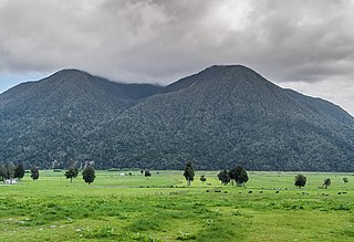
Mount Te Kinga is a mountain on the West Coast of New Zealand's South Island within the western foothills of the Southern Alps / Kā Tiritiri o te Moana. The mountain is on the south-eastern shore of Lake Brunner and is not a part of a larger mountain range, being separated from the Hohonu Range to the west by the Orangipuku River and from the Alexander Range to the southeast by the Poerua River. Numerous small creeks flow from Te Kinga, all of which end up eventually flowing into the nearby Lake Brunner.
