
The Great Lakes, also called the Great Lakes of North America, are a series of large interconnected freshwater lakes in the east-central interior of North America that connect to the Atlantic Ocean via the Saint Lawrence River. The five lakes are Superior, Michigan, Huron, Erie, and Ontario, and they are in general on or near the Canada–United States border. Hydrologically, Michigan and Huron are a single body of water joined at the Straits of Mackinac. The Great Lakes Waterway enables modern travel and shipping by water among the lakes.

Lake Superior is the largest freshwater lake in the world by surface area and the third-largest freshwater lake by volume, holding 10% of the world's surface fresh water. Located in central North America, it is the northernmost and westernmost of the Great Lakes of North America, straddling the Canada–United States border with the Canadian province of Ontario to the north and east and the U.S. states of Minnesota to the west and Michigan and Wisconsin to the south. It drains into Lake Huron via St. Marys River, then through the lower Great Lakes to the St. Lawrence River and ultimately the Atlantic Ocean.

The Mississippi River is the primary river and second-longest river of the largest drainage basin in the United States. From its traditional source of Lake Itasca in northern Minnesota, it flows generally south for 2,340 miles (3,766 km) to the Mississippi River Delta in the Gulf of Mexico. With its many tributaries, the Mississippi's watershed drains all or parts of 32 U.S. states and two Canadian provinces between the Rocky and Appalachian mountains. The main stem is entirely within the United States; the total drainage basin is 1,151,000 sq mi (2,980,000 km2), of which only about one percent is in Canada. The Mississippi ranks as the thirteenth-largest river by discharge in the world. The river either borders or passes through the states of Minnesota, Wisconsin, Iowa, Illinois, Missouri, Kentucky, Tennessee, Arkansas, Mississippi, and Louisiana.

The Nile is a major north-flowing river in northeastern Africa. It flows into the Mediterranean Sea. The Nile is the longest river in Africa and has historically been considered the longest river in the world, though this has been contested by research suggesting that the Amazon River is slightly longer. Of the world's major rivers, the Nile is one of the smallest, as measured by annual flow in cubic metres of water. About 6,650 km (4,130 mi) long, its drainage basin covers eleven countries: the Democratic Republic of the Congo, Tanzania, Burundi, Rwanda, Uganda, Kenya, Ethiopia, Eritrea, South Sudan, Sudan, and Egypt. In particular, the Nile is the primary water source of Egypt, Sudan and South Sudan. Additionally, the Nile is an important economic river, supporting agriculture and fishing.

The St. Lawrence River is a large international river in the middle latitudes of North America connecting the Great Lakes to the North Atlantic Ocean. Its waters flow in a northeasterly direction from Lake Ontario to the Gulf of St. Lawrence, traversing Ontario and Quebec in Canada and New York in the United States. A section of the river demarcates the Canada–U.S. border.

The Taramakau River is a river of the West Coast Region of the South Island of New Zealand. It rises in the Southern Alps / Kā Tiritiri o te Moana near Harper Pass, 80 kilometres (50 mi) due east of Hokitika, and runs westward for 75 kilometres (47 mi) into the Tasman Sea 15 kilometres (9.3 mi) south of Greymouth.
Poerua River is a river in Westland District in the West Coast region of New Zealand's South Island. It flows from its headwaters in the Southern Alps to the Tasman Sea near Harihari. The river is a trout and salmon fishing location and its mouth is where it is met by the Hinatua River and is located roughly a kilometre south of the Wanganui River's mouth. On the morning of 6 October 1999, a landslide from Mount Adams blocked the Poerua River, creating a landslide dam about 11 km upstream from the State Highway 6 bridge over the river. Despite fears of flooding and other damage, there were relatively minimal impacts when the dam was breached six days later, though significant quantities of coarse gravel were deposited downstream and the river's course was changed in places.

Lake Poerua is a shallow lake located in the West Coast region of New Zealand's South Island roughly 13 km southeast from Lake Brunner. It is located between the Alexander Range and the slopes of Mount Te Kinga, to the north of the lake. The area around Lake Poerua is sparsely populated. A number of small streams flow into the lake, and the Poerua River flows from the lake into the Crooked River, which leads to Lake Brunner.

Crooked River is a river that flows from headwaters in the Southern Alps to Lake Brunner in the West Coast region of New Zealand's South Island. It is named for the erratic path it takes. Near Lake Brunner, it passes through reasonably flat farmland, but closer to its source, it rushes through gorges and rapids. One tributary is the Poerua River from Lake Poerua.

Inchbonnie is a rural locality in the West Coast region of the South Island of New Zealand. It is located on the north bank of the Taramakau River and is just to the south of Lake Poerua. "Inchbonnie" is a hybrid of Lowland Scots, bonnie meaning "pretty" and Scottish Gaelic innis meaning island, often anglicised as "Inch", as in Inchkeith or Inchkenneth in Scotland.
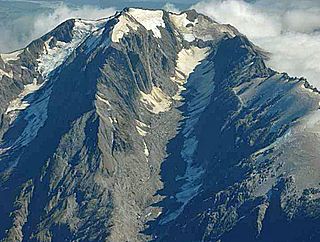
Mount Adams is a mountain in the West Coast region of New Zealand's South Island. The summit is roughly 19 km south of Harihari and reaches 2,208 metres (7,244 ft) in height.
The Hinatua River is a small river in the Westland District of New Zealand's South Island. Its headwaters are on Mount Hercules, near State Highway 6 as it runs between Harihari and Te Taho. The Hinatua River then flows in a general northerly direction, passing just to the east of the Saltwater Lagoon before flowing close to the Tasman Sea coastline before joining the Poerua River at its rivermouth.
The Brown River is a short river of New Zealand. It flows northwest to meet the Poerua River five kilometres southeast of Lake Brunner.
The Ōrangipuku River is a river of the West Coast Region of New Zealand's South Island. It flows north into the southern end of Lake Brunner.
The Willberg River is a river of the West Coast Region of New Zealand's South Island. It initially flows northwest before turning southwest, reaching the Poerua River 12 kilometres south of Harihari.
Poerua River may refer to one of two rivers on the West Coast of New Zealand's South Island:
An ecological area is a type of New Zealand protected area. They are usually large and usually feature the main ecosystems of a defined ecological district. There are currently 57 recognised ecological areas in New Zealand.
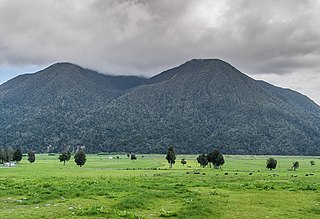
Mount Te Kinga is a mountain on the West Coast of New Zealand's South Island within the western foothills of the Southern Alps / Kā Tiritiri o te Moana. The mountain is on the south-eastern shore of Lake Brunner and is not a part of a larger mountain range, being separated from the Hohonu Range to the west by the Orangipuku River and from the Alexander Range to the southeast by the Poerua River. Numerous small creeks flow from Te Kinga, all of which end up eventually flowing into the nearby Lake Brunner.
Kangaroo Lake is a small dystrophic lake on the West Coast of New Zealand's South Island. The lake is roughly 3 kilometres (1.9 mi) east of the much larger Lake Brunner, and is popular with both duck hunters and recreational fishermen. There is no road access to the lake, with access only via tracks.
