
The Lower Mainland is a geographic and cultural region of the mainland coast of British Columbia that generally comprises the regional districts of Metro Vancouver and the Fraser Valley. Home to approximately 3.05 million people as of the 2021 Canadian census, the Lower Mainland contains sixteen of the province's 30 most populous municipalities and approximately 60% of the province's total population.

The Buller River is a river in the South Island of New Zealand. The Buller has the highest flow of any river in the country during floods, though it is only the 13th longest river; it runs for 177 km (110 mi) from Lake Rotoiti through the Buller Gorge and into the Tasman Sea near the town of Westport. A saddle at 710 m (2,330 ft) separates the Buller from the Motupiko River and that is divided from the Wairau River by a 695 m (2,280 ft) saddle, both aligned along the Alpine Fault, as is the top of the Buller valley.
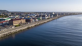
Greymouth is the largest town in the West Coast region in the South Island of New Zealand, and the seat of the Grey District Council. The population of the whole Grey District is 14,250, which accounts for 43% of the West Coast's inhabitants. The Greymouth urban area had an estimated population of 8,340. A large proportion of the District, 65%, is part of the Conservation Estate owned and managed by the Department of Conservation making Greymouth a natural centre for walkers and trampers.
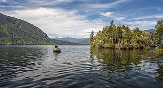
Lake Brunner is the largest lake in the West Coast Region of New Zealand, located 31 km (19 mi) southeast of Greymouth. The main settlement, Moana, is on its northern shore. It is an important settlement and waystation for local Māori. The first Europeans in the area were loggers, and sawmills were an important early industry. Being several kilometres inland from the coast road, it is less frequently visited by tourists than many of the West Coast's scenic highlights, but it is becoming increasingly popular, in part due to its reputation for fishing.

The Taramakau River is a river of the West Coast Region of the South Island of New Zealand. It rises in the Southern Alps / Kā Tiritiri o te Moana near Harper Pass, 80 kilometres (50 mi) due east of Hokitika, and runs westward for 75 kilometres (47 mi) into the Tasman Sea 15 kilometres (9.3 mi) south of Greymouth.

The Wanganui River is in the West Coast of the South Island of New Zealand. It flows northwest for 55 kilometres (34 mi) from its headwaters in the Southern Alps, entering the Tasman Sea near Lake Ianthe, 40 kilometres (25 mi) southwest of Hokitika.

The Wivenhoe Dam is a rock and earth-fill embankment dam with a concrete spillway across the Brisbane River in South East Queensland, Australia. The dam takes it names from the local Wivenhoe Pocket rural community. The dam wall is located about 80 kilometres (50 mi) by road from the centre of Brisbane. The primary purpose of the dam is the supply of potable water for the Brisbane and Ipswich regions. The dam also provides for flood mitigation control, hydroelectricity, and recreation. The impounded reservoir is called Lake Wivenhoe and the dam, the lake and a narrow strip of surrounding land forms a locality also called Lake Wivenhoe.

Lake Poerua is a shallow lake located in the West Coast region of New Zealand's South Island roughly 13 km southeast from Lake Brunner. It is located between the Alexander Range and the slopes of Mount Te Kinga, to the north of the lake. The area around Lake Poerua is sparsely populated. A number of small streams flow into the lake, and the Poerua River flows from the lake into the Crooked River, which leads to Lake Brunner.
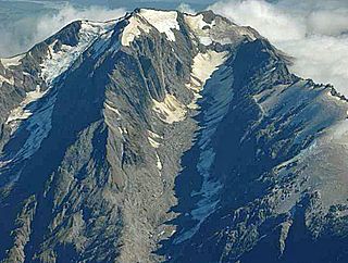
Mount Adams is a mountain in the West Coast region of New Zealand's South Island. The summit is roughly 19 km south of Harihari and reaches 2,208 metres (7,244 ft) in height.

Franz Josef is a small town in the West Coast region of the South Island of New Zealand. Whataroa is 32 kilometres (20 mi) to the north-east, and the township of Fox Glacier is 23 kilometres (14 mi) to the south-west. The Waiho River runs from the Franz Josef Glacier to the south, through the town, and into the Tasman Sea to the north-west.
The Mōkihinui River is a river located on the West Coast of New Zealand's South Island, about 40 kilometres north of Westport. Meridian Energy had proposed the Mokihinui Hydro project on the river in 2007 but it was cancelled in May 2012. In 2019, it was announced that 64,400 ha of land in the Mōkihinui River catchment, including 15 km (9.3 mi) of river bed, would be added to Kahurangi National Park.
The Edgar Dam is an earthfill embankment saddle dam without a spillway, located offstream in the South West region of Tasmania, Australia.
The Mokihinui Hydro was a proposed hydroelectric dam and power station planned for conservation land on the Mōkihinui River on the West Coast of New Zealand. The project by Meridian Energy was expected to cost $300 million.

The Karamea River is located in the West Coast Region of the South Island of New Zealand. The river rises within Kahurangi National Park in the Matiri Range of the Southern Alps. The river rises to the east of Mount Allen, meandering west briefly before turning north. After some 25 km (16 mi) it again turns west, to enter a series of small lakes where its waters are joined by those of the Roaring Lion River. From here the river continues west through steep-sided valleys before leaving the national park and reaching its floodplain 10 km (6.2 mi) from the coast of the Tasman Sea. The river passes the small settlements of Umere and Arapito before reaching the Ōtūmahana Estuary and the Tasman Sea close to the township of Karamea.
The Ōrangipuku River is a river of the West Coast Region of New Zealand's South Island. It flows north into the southern end of Lake Brunner.

The Waitangitāhuna River are two rivers in the West Coast region of New Zealand's South Island. It was a single river until an avulsion in March 1967, when it became two rivers. Since then, the southern portion of the river has flowed into Lake Wahapo, while the northern section discharges into the Tasman Sea north of Ōkārito Lagoon.

The Arnold River is a river on the West Coast of New Zealand's South Island. It is the outflow of Lake Brunner, which it links with the Grey River at Stillwater. The Arnold River flows northwest for 20 kilometres (12 mi), joining the Grey immediately above the town of Brunner, some 15 kilometres (9 mi) from the Tasman Sea. It is a popular spot for whitewater kayaking and trout fishing.

The West Coast Wilderness Trail has been funded as one of the projects of the New Zealand Cycle Trail. Once complete, the 139 kilometres (86 mi) track will connect Greymouth in the north with Ross in the south.
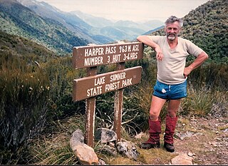
Harper Pass, previously known as Hurunui Pass or sometimes Taramakau Pass, is an alpine pass between Canterbury and the West Coast in New Zealand. It was the most important crossing for Māori to obtain pounamu. The first European crossed the pass in 1857 and the leader of the second party later that year, Leonard Harper, gave the pass its current name. It was of some interest to the settlers as the West Coast was part of Canterbury Province and it remained the only feasible route for some years. When the West Coast Gold Rush started in 1864, it became a heavily used crossing and remained so until October 1865, when a dray road over Arthur's Pass opened. The Arthur's Pass route was upgraded in March 1866 to coach traffic standard, and the much less direct route over Harper Pass fell out of use. It was restored in the 1930s as a tramping route and the Harper Pass Track, a four or five-day tramp, is today part of Te Araroa over its entire length.
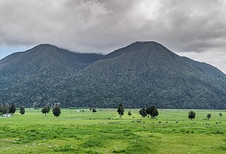
Mount Te Kinga is a mountain on the West Coast of New Zealand's South Island within the western foothills of the Southern Alps / Kā Tiritiri o te Moana. The mountain is on the south-eastern shore of Lake Brunner and is not a part of a larger mountain range, being separated from the Hohonu Range to the west by the Orangipuku River and from the Alexander Range to the southeast by the Poerua River. Numerous small creeks flow from Te Kinga, all of which end up eventually flowing into the nearby Lake Brunner.

