
Jackson Bay / Okahu is a gently curving 24-kilometre (15 mi) bay on the southern West Coast of the South Island of New Zealand. It faces the Tasman Sea to the north, and is backed by the Southern Alps. It contains the settlements of Hannahs Clearing, Waiatoto, Neils Beach, and the fishing village of Jackson Bay at its western end. The bay is the southernmost terminus of the West Coast's roads.

The Cook River / Weheka is in the South Island of New Zealand. The headwaters are from the La Perouse Glacier on the western flanks of the Southern Alps / Kā Tiritiri o te Moana, and it flows west, then northeast, then northwest and into the Tasman Sea. Its tributaries include the Balfour River, fed by Balfour Glacier, and the Fox River, fed by Fox Glacier / Te Moeka o Tuawe. Much of the river lies within the Westland Tai Poutini National Park. The river was renamed from Cook River to Cook River / Weheka as a result of the Ngāi Tahu Claims Settlement Act 1998.
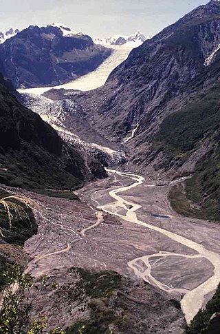
Fox Glacier is a 13-kilometre-long (8.1 mi) temperate maritime glacier located in Westland Tai Poutini National Park on the West Coast of New Zealand's South Island. Like nearby Franz Josef Glacier, Fox Glacier is one of the most accessible glaciers in the world, with a terminal face as low as 300 m above sea level, close to the village of Fox Glacier. It is a major tourist attraction and about 1000 people daily visit it during high tourist season.
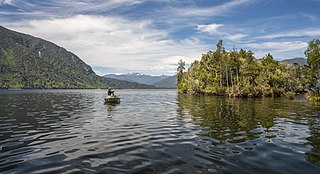
Lake Brunner is the largest lake in the West Coast Region of New Zealand, located 31 km (19 mi) southeast of Greymouth. The main settlement, Moana, is on its northern shore. It is an important settlement and waystation for local Māori. The first Europeans in the area were loggers, and sawmills were an important early industry. Being several kilometres inland from the coast road, it is less frequently visited by tourists than many of the West Coast's scenic highlights, but it is becoming increasingly popular, in part due to its reputation for fishing.

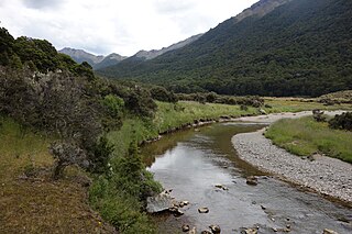
The Taramakau River is a river of the West Coast Region of the South Island of New Zealand. It rises in the Southern Alps / Kā Tiritiri o te Moana near Harper Pass, 80 kilometres (50 mi) due east of Hokitika, and runs westward for 75 kilometres (47 mi) into the Tasman Sea 15 kilometres (9.3 mi) south of Greymouth.

Lake Kaniere is a glacial lake located on the West Coast of New Zealand's South Island, nearly 200 m deep and surrounded on three sides by mountains and mature rimu forest. It is regarded by many as the most beautiful of the West Coast lakes, and is a popular tourist and leisure destination.

The Westland Province was a province of New Zealand from 1873 until the abolition of provincial government in 1876. The capital was Hokitika.
Poerua River is a river in Westland District in the West Coast region of New Zealand's South Island. It flows from its headwaters in the Southern Alps to the Tasman Sea near Harihari. The river is a trout and salmon fishing location and its mouth is where it is met by the Hinatua River and is located roughly a kilometre south of the Wanganui River's mouth. On the morning of 6 October 1999, a landslide from Mount Adams blocked the Poerua River, creating a landslide dam about 11 km upstream from the State Highway 6 bridge over the river. Despite fears of flooding and other damage, there were relatively minimal impacts when the dam was breached six days later, though significant quantities of coarse gravel were deposited downstream and the river's course was changed in places.

Lake Poerua is a shallow lake located in the West Coast region of New Zealand's South Island roughly 13 km southeast from Lake Brunner. It is located between the Alexander Range and the slopes of Mount Te Kinga, to the north of the lake. The area around Lake Poerua is sparsely populated. A number of small streams flow into the lake, and the Poerua River flows from the lake into the Crooked River, which leads to Lake Brunner.

Inchbonnie is a rural locality in the West Coast region of the South Island of New Zealand. It is located on the north bank of the Taramakau River and is just to the south of Lake Poerua. "Inchbonnie" is a hybrid of Lowland Scots, bonnie meaning "pretty" and Scottish Gaelic innis meaning island, often anglicised as "Inch", as in Inchkeith or Inchkenneth in Scotland.
The Brown River is a short river of New Zealand. It flows northwest to meet the Poerua River five kilometres southeast of Lake Brunner.
The Cobb River is a river in the Tasman Region of New Zealand. It flows southeast from Lake Cobb on the northern slopes of Mount Cobb, in Kahurangi National Park, in the northwestern South Island. The river's waters are captured behind a dam to become the Cobb Reservoir; the outflow continues to join with the Tākaka River. The river is named for J.W. Cobb, a local mill owner.
The Evans River is a short river in New Zealand's South Island. It arises near Mount O'Shanessy in the Kaimata Range of the Southern Alps and flows north-west and then south-west, joining the Crooked River several kilometres before the latter's outflow into Lake Brunner.

The Haupiri River is a river of New Zealand. It starts near Mount Dixon in the Kaimata Range of the Southern Alps and flows north-west near to Lake Haupiri, then north-east to join the Ahaura River. The Ahaura joins the Grey River which flows into the Tasman Sea at Greymouth.
The Morgan River is a river of the West Coast Region of New Zealand's South Island. It flows generally west from the small Lake Morgan, high in the Kaimata Range of the Southern Alps, reaching the Crooked River 18 kilometres (11 mi) from the latter's outflow into Lake Brunner.
The Ōrangipuku River is a river of the West Coast Region of New Zealand's South Island. It flows north into the southern end of Lake Brunner.

The Arnold River is a river on the West Coast of New Zealand's South Island. It is the outflow of Lake Brunner, which it links with the Grey River at Stillwater. The Arnold River flows northwest for 20 kilometres (12 mi), joining the Grey immediately above the town of Brunner, some 15 kilometres (9 mi) from the Tasman Sea. It is a popular spot for whitewater kayaking and trout fishing.
Grey County was one of the counties of New Zealand in the South Island.
Poerua River is a river in the Grey District in the West Coast region of New Zealand's South Island. It flows around the base of Mount Te Kinga from Lake Poerua into the Crooked River, which leads to Lake Brunner.

