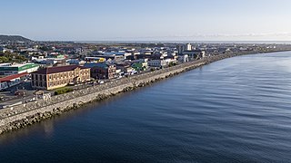
Greymouth is the largest town in the West Coast region in the South Island of New Zealand, and the seat of the Grey District Council. The population of the whole Grey District is 14,250, which accounts for 43% of the West Coast's inhabitants. The Greymouth urban area had an estimated population of 8,340. A large proportion of the District, 65%, is part of the Conservation Estate owned and managed by the Department of Conservation making Greymouth a natural centre for walkers and trampers.

Inangahua is a small settlement in the northwest of New Zealand's South Island. It consists of three settled areas: Inangahua Junction at the confluence of the Inangahua and Buller Rivers, 34 kilometres (21 mi) north of Reefton and 46 kilometres (29 mi) southeast of Westport; Inangahua Landing, 10 km further up the Inangahua River; and Inangahua township, 2 km east of the Junction. Murchison is 52 kilometres (32 mi) further east. After the 1968 Inangahua Earthquake, most of the inhabitants left the area or shifted to the township, which is now the population centre and known simply as Inangahua.
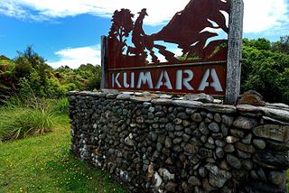
Kumara is a town on the West Coast of the South Island of New Zealand. It is located 30 kilometres (19 mi) south of Greymouth, close to the western end of State Highway 73, which leads across Arthur's Pass to Christchurch. The Taramakau River flows past to the north.

Colville, a small town in the north of the Coromandel Peninsula in the North Island of New Zealand, lies 26 kilometres north of Coromandel in Colville Bay on the Hauraki Gulf, and is the northernmost town of any note on the peninsula. North of Colville, 28 kilometres of rough road lead to the small settlement of Port Jackson, close to the peninsula's northwesternmost point, Cape Colville and 20 km to Port Charles on the northeastern side.
Dobson is a small town on the banks of the Grey River in the South Island of New Zealand. It is 10 kilometres (6 mi) east from the river's mouth at Greymouth. The settlement of Taylorville is across the river from Dobson, but no bridge directly connects the two. State Highway 7 passes through Dobson.

Hope, previously known as Ranzau, is a small settlement in the Tasman District of New Zealand. It lies south of Nelson city, between Richmond and Wakefield.

Tata Beach is a beach and small coastal settlement of predominantly holiday houses in the South Island, New Zealand. Found in the Golden Bay region, it is approximately 20 kilometres (12 mi) north-east of Tākaka.
Motatau or Mōtatau is a locality in the Northland Region of the North Island of New Zealand. Maromaku is to the east. The Taikirau Stream flows from east through Motatau and then runs northwest to join the Waiharakeke Stream. The North Auckland Line runs through Motatau.
Rawhitiroa is a locality situated in South Taranaki, New Zealand. It is positioned approximately 6.5 km east of Eltham.

Paroa is a settlement on the West Coast of the South Island of New Zealand, just south of Greymouth. State Highway 6 and the Hokitika Branch railway both run through Paroa. This railway was originally a bush tramway that opened to Paroa from Greymouth in 1867 and was extended to Kumara in 1877. It was converted into a railway in 1893, and this time, ran from Paroa to Hokitika rather than Kumara.
Karoro is a suburb to the south-west of Greymouth on the West Coast of New Zealand.

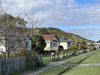
Cobden is a suburb to the north of Greymouth on the West Coast of New Zealand. The Grey River separates Cobden from the rest of Greymouth. To the north is the Rapahoe Range, also called the Twelve Apostles Range. State Highway 6 skirts the south-eastern edge of Cobden.

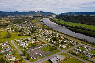
Ahaura is a town in the West Coast region of New Zealand's South Island, sited where the Ahaura River flows into the Grey River. State Highway 7 and the Stillwater–Ngākawau railway line pass through the town. Greymouth is 34 kilometres (21 mi) to the south-west, and Reefton is 44 kilometres (27 mi) to the north-east.

Kaipara Flats is a locality in the Rodney District of New Zealand. Warkworth is 12 km to the east, Ahuroa to the south, and Tauhoa to the north-west. The North Auckland railway line passes through the area.

Anakiwa is a coastal residential village in the Marlborough region of New Zealand. It sits at the head of Queen Charlotte Sound/Tōtaranui, one of the Marlborough Sounds, 23 km (14 mi) west of Picton and 18 km (11 mi) east of Havelock. At the 2018 census, the village had a usual resident population of 171.
Waianiwa is a town and statistical area in the Southland region of the South Island of New Zealand.

Waitakaruru is a rural community in the Hauraki District and Waikato region of New Zealand's North Island. It is situated at the mouth of Waitakaruru River

Greymouth Central is the central business district of Greymouth on the West Coast of New Zealand, which also contains residential housing.
Wharemoa is a southeastern suburb of Greymouth on the West Coast of New Zealand. Marsden Road is a major road running through the suburb. Sawyers Creek runs northwest through the suburb to join the Grey River / Māwheranui near its mouth on the Tasman Sea.
Ferndale is a suburb of New Plymouth, in the western North Island of New Zealand. It is located to the south of the city centre.


