
Ross is a small town located in the Westland District on the West Coast of New Zealand's South Island, 27 kilometres (17 mi) south-west of Hokitika and 46 kilometres (29 mi) north-east of Hari Hari by road.

The NZR RM class Midland railcar was the first successful railcar, and first diesel-powered vehicle, to enter revenue service in New Zealand. Two were built, RM 20 and RM 21, and they ran for five years from 1936 to 1941 before being replaced by larger Vulcan railcars. They operated primarily on the Midland Line and the Greymouth-Hokitika portion of the Ross Branch
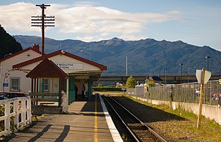
The Ross Branch, officially known as the Hokitika Line since 2011, and previously as the Hokitika Industrial Line, is a branch line railway that forms part of New Zealand's national rail network. It is located in the Westland District of the South Island's West Coast region and opened to Hokitika in 1893. A further extension to Ross operated from 1909 until 1980.
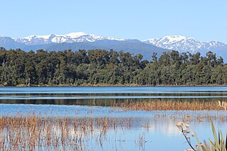
Lake Mahinapua is a shallow lake on the West Coast of New Zealand's South Island. Once a lagoon at the mouth of the Hokitika River, it became a lake when the river shifted its course. Lake Māhinapua was the site of a significant battle between Ngāi Tahu and Ngāti Wairangi Māori, and is regarded by them as a sacred site where swimming and fishing are prohibited. In European times it was part of an inland waterway that carried timber and settlers between Hokitika and Ross until the building of the railway. Today it is protected as a scenic reserve for boating, camping, and hiking.
Stillwater is a town in the South Island of New Zealand east of Greymouth on the banks of the Grey River, at the confluence with the Arnold River, in the Grey District of the West Coast, next to Brunner. There is also a Stillwater, Auckland in the North Island.

Franz Josef is a small town in the West Coast region of the South Island of New Zealand. Whataroa is 32 kilometres (20 mi) to the north-east, and the township of Fox Glacier is 23 kilometres (14 mi) to the south-west. The Waiho River runs from the Franz Josef Glacier to the south, through the town, and into the Tasman Sea to the north-west.

Bruce Bay is a bay and settlement in South Westland, New Zealand on the Tasman Sea. It is located on State Highway 6, 74 kilometres (46 mi) northeast of Haast and 45 kilometres (28 mi) southwest of Fox Glacier. The small settlement of Bruce Bay is located just south of the mouth of Mahitahi River. The bay is a nesting ground for the Fiordland crested penguin, and endemic Hector's dolphins and southern right whales can be observed from the shore on occasion. Some of the bush around the bay has been cleared for farming, and quartz stones can be found on the beach.
John Bevan was a 19th-century member of the House of Representatives. He was an auctioneer and merchant from Hokitika on the West Coast of New Zealand.

Shantytown Heritage Park, usually known as Shantytown, is a tourist attraction in the West Coast Region of the South Island of New Zealand. Located 10 kilometres (6.2 mi) south of Greymouth, the Heritage Park opened in 1971 and consists of 30 re-created historic buildings making up a 19th-century gold-mining town. The town is surrounded by native forest, and is one of the region's most popular attractions.

Alexander Carter Graham (1881–1957) and Peter Graham (1878–1961) were mountaineers, guides and hotel operators in New Zealand. They were instrumental in the establishment of the early New Zealand tourist industry and earned themselves worldwide reputations as climbers and guides.

The Westport News is an independently-owned evening newspaper published in Westport, New Zealand. It is published on weekdays, and is one of New Zealand's smallest independent newspapers. The Westport News is distributed from Karamea in the north to Punakaiki in the south and as far inland as Reefton.

Taylorville is a small town on the banks of the Grey River, It is roughly 10 kilometers from the mouth of the river in Greymouth.

James Holmes was a member of the New Zealand Legislative Council from Hokitika on the West Coast.

Westland County, also known as County of Westland, was a local government area on the West Coast of New Zealand's South Island. It existed from 1868 to 1873, and then from 1876 until 1989. In its first incarnation, it constituted the government for the area that was split from the Canterbury Province, with the West Coast Gold Rush having given the impetus for that split. It had the same administrative powers as a provincial council, but the legislative power rested with Parliament in Wellington. The first Westland County was the predecessor to Westland Province.

The Hokitika Borough was the borough council covering the urban part of the town of Hokitika, New Zealand between 1867 and 1989, when Hokitika Borough and Westland County merged to form Westland District.

The West Coast Wilderness Trail has been funded as one of the projects of the New Zealand Cycle Trail. Once complete, the 139 kilometres (86 mi) track will connect Greymouth in the north with Ross in the south.
The Brunner Borough was a borough on New Zealand's West Coast from 1887 to 1971. It was formed from an area that belonged to Grey County and, at disestablishment, merged back into Grey County.

Hokitika Gorge and the surrounding Hokitika Gorge Scenic Reserve are a major tourist destination some 33 kilometres (21 mi) or 40 minutes drive inland from Hokitika, New Zealand. Since August 2020, a second suspension bridge over the Hokitika River at the gorge provides the opportunity for a round track.

Rimu, originally known as Upper Woodstock, is a small town in the Westland District of New Zealand's South Island.

The Hokitika Savings Bank building is a former bank building in Hokitika, on the West Coast of New Zealand's South Island. Completed in 1927, the building was granted historic place category 2 status by Heritage New Zealand in 1989.


