Renwick is a small town in Marlborough, New Zealand, close to the south bank of the Wairau River. It is located on State Highway 6, 12 kilometres (7 mi) west of Blenheim. Havelock is 31 km (19 mi) north. State Highway 63 runs southwest from Renwick through the Wairau River valley.
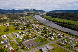
Dobson is a small town on the banks of the Grey River in the South Island of New Zealand. It is 10 kilometres (6 mi) east from the river's mouth at Greymouth. The settlement of Taylorville is across the river from Dobson, but no bridge directly connects the two. State Highway 7 passes through Dobson.
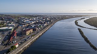
Grey District is a district in the West Coast Region of New Zealand that covers Greymouth, Runanga, Blackball, Cobden, and settlements along the Grey River. It has a land area of 3,474.44 square kilometres (1,341.49 sq mi). The seat of the Grey District Council, the local government authority that administers the district, is at Greymouth, where 58.5% of the district's population live.
Waimangaroa is a small town located on the West Coast of New Zealand.

Kirwee is a town located west of Christchurch in the Canterbury region of New Zealand's South Island. It was named after Karwi in India by retired British Army colonel De Renzie Brett. Kirwee is also home to the South Island Agricultural Field Days, held biennially.

Moana is a small town in the West Coast Region of the South Island of New Zealand. It is situated on the northern shore of Lake Brunner, and is beside the outflow of the lake into the Arnold River. There is a pedestrian suspension bridge crossing the Arnold from the town to access the lake shore across the river, with some short easy bush walks on each side.

Tata Beach is a beach and small coastal settlement of predominantly holiday houses in the South Island, New Zealand. Found in the Golden Bay region, it is approximately 20 kilometres (12 mi) north-east of Tākaka.

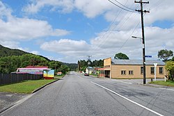
Ahaura is a town in the West Coast region of New Zealand's South Island, sited where the Ahaura River flows into the Grey River. State Highway 7 and the Stillwater–Ngākawau railway line pass through the town. Greymouth is 34 kilometres (21 mi) to the south-west, and Reefton is 44 kilometres (27 mi) to the north-east.

Matarangi is a beach settlement on the Coromandel Peninsula of New Zealand, with around 420 permanent residents in 2018 which increases to over 7000 holidaymakers during the summer period of late December to February. It was developed in the 1980s as a purpose-built resort town and occupies a white sand peninsula between the Whangapoua Harbour and historic Mercury Bay. It is half an hour from the towns of Coromandel to the west and Whitianga to the south east.

Timaru District is a local government district on New Zealand's South Island, administered by the Timaru District Council. It is part of the larger Canterbury Region. Timaru district was formed in 1989 from the amalgamation of Timaru City, Geraldine district, Temuka district and Stratham district.

Whanganui District is one of the districts of New Zealand. It includes the city of Whanganui and surrounding areas.
Waikaia, formerly known as Switzers, is a town in the Southland region of New Zealand's South Island. From 1909 until 1959, it was the terminus of the Waikaia Branch railway. The population in the 2013 census was 99, unchanged from the previous census in 2006.

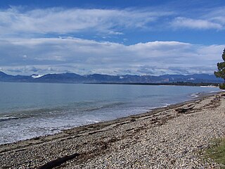
Carters Beach is a suburb of Westport on the West Coast of New Zealand's South Island. Located 6 kilometres (4 mi) west of Westport on State Highway 67A, it offers a pristine sheltered sandy beach on the West Coast suitable for swimming. From the Buller River jetty at the east end of Carters Beach, west to Cape Foulwind, the beach runs for more than 9 uninterrupted kilometres.

Ashley is a small town in North Canterbury, in the South Island of New Zealand. It used to have a railway station on the Main North Line that runs through the village.
Waihou is a rural settlement in the Matamata-Piako District and Waikato region of New Zealand's North Island.
The Brunner Borough was a borough on New Zealand's West Coast from 1887 to 1971. It was formed from an area that belonged to Grey County and, at disestablishment, merged back into Grey County.
Ruby Bay is a settlement in the Tasman District of New Zealand's upper South Island. It is located between Māpua and Tasman on Te Mamaku / Ruby Bay. Ruby Bay was named after small 'rubies' found within the moutere gravel.
Milford Huts is a bach community in the Timaru district and Canterbury region of New Zealand's South Island. Milford Huts is on the northern side of the Ōpihi River mouth, 7.5 kilometres southeast of Temuka by road.

Waiomu is a settlement on the west coast of the Coromandel Peninsula of New Zealand, between Tapu to the north and Te Puru to the south. State Highway 25 runs through it.

Ōhiwa is a rural settlement in the Ōpōtiki District and Bay of Plenty Region of New Zealand's North Island. It is on a headland on the eastern side of Ōhiwa Harbour, and on the western side of the Waiotahe River mouth.