Related Research Articles

Hawke's Bay is a region on the east coast of New Zealand's North Island. The region is named for Hawke Bay, which was named in honour of Edward Hawke. The region's main centres are the cities of Napier and Hastings, while the more rural parts of the region are served by the towns of Waipukurau, Waipawa, and Wairoa.

Gisborne is a city in northeastern New Zealand and the largest settlement in the Gisborne District. It has a population of 38,800. Gisborne District Council has its headquarters in the central city.

The Waikato is a region of the upper North Island of New Zealand. It covers the Waikato District, Waipa District, Matamata-Piako District, South Waikato District and Hamilton City, as well as Hauraki, Coromandel Peninsula, the northern King Country, much of the Taupō District, and parts of the Rotorua Lakes District. It is governed by the Waikato Regional Council.

The Waikato River is the longest river in New Zealand, running for 425 kilometres (264 mi) through the North Island. It rises on the eastern slopes of Mount Ruapehu, joining the Tongariro River system and flowing through Lake Taupō, New Zealand's largest lake. It then drains Taupō at the lake's northeastern edge, creates the Huka Falls, and flows northwest through the Waikato Plains. It empties into the Tasman Sea south of Auckland, at Port Waikato. It gives its name to the Waikato region that surrounds the Waikato Plains. The present course of the river was largely formed about 17,000 years ago. Contributing factors were climate warming, forest being reestablished in the river headwaters and the deepening, rather than widening, of the existing river channel. The channel was gradually eroded as far up river as Piarere, leaving the old Hinuera channel through the Hinuera Gap high and dry. The remains of the old course are seen clearly at Hinuera, where the cliffs mark the ancient river edges. The Waikato's main tributary is the Waipā River, which converges with it at Ngāruawāhia.

The Ahaura River is in the South Island of New Zealand. This river drains the western flanks of the Southern Alps and flows into the Grey River.
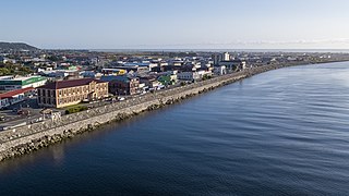
Greymouth is the largest town in the West Coast region in the South Island of New Zealand, and the seat of the Grey District Council. The population of the whole Grey District is 14,800, which accounts for 43% of the West Coast's inhabitants. The Greymouth urban area had an estimated population of 8,640. A large proportion of the District, 65%, is part of the Conservation Estate owned and managed by the Department of Conservation making Greymouth a natural centre for walkers and trampers.

Kahurangi National Park is a national park in the northwest of the South Island of New Zealand. It is the second largest of the thirteen national parks of New Zealand. It was gazetted in 1996 and covers 5,193 km2 (2,005 sq mi), ranging from the Buller River near Murchison in the south, to the base of Farewell Spit in Golden Bay in the north. The park has no single dominant landform, but includes an unusually wide variety of landscapes, including mountain ranges, rivers, gorges, raised peneplains and karst features such as caves and arches. Many of the landforms within the park are considered to be nationally or internationally significant.

The Otago gold rush was a gold rush that occurred during the 1860s in Central Otago, New Zealand. This was the country's biggest gold strike, and led to a rapid influx of foreign miners to the area – many of them veterans of other hunts for the precious metal in California and Victoria, Australia. The number of miners reached its maximum of 18,000 in February 1864.

The Manawatū River is a major river of the lower North Island of New Zealand. The river flows from the Ruahine Ranges, through both the Manawatū Gorge and the city of Palmerston North, and across the Manawatū Plains to the Tasman Sea at Foxton.
The Canterbury Province was a province of New Zealand from 1853 until the abolition of provincial government in 1876. Its capital was Christchurch.
Ngāti Raukawa is a Māori iwi with traditional bases in the Waikato, Taupō and Manawatu/Horowhenua regions of New Zealand. In 2006, 29,418 Māori registered their affiliation with Ngāti Raukawa.
The Gorge River is a river on the West Coast of New Zealand. It arises in the Hope Blue River Range and flows south-west into the Tasman Sea. Its tributaries include the Duncan River and Jerry River. It passes through Cascade Forest. Its mouth is about 15 km north-east of Awarua Point. The Gorge Islands are very small islands near the mouth. At its mouth, it is a fast tidal river.
The Ngatau River is a river of the West Coast region of New Zealand's South Island. It flows north-west from its sources in the Southern Alps to meet the Okuru River 20 kilometres (12 mi) south-east of Haast. The river's entire length is within Mount Aspiring National Park.
The Ōmoeroa River is a river of the West Coast region of New Zealand's South Island. It flows northwest from its source high in the Southern Alps, 14 kilometres north of Aoraki / Mount Cook, reaching the Tasman Sea 12 kilometres west of Franz Josef.

The Waitangitāhuna River are two rivers in the West Coast region of New Zealand's South Island. It was a single river until an avulsion in March 1967, when it became two rivers. Since then, the southern portion of the river has flowed into Lake Wahapo, while the northern section discharges into the Tasman Sea north of Ōkārito Lagoon.

The Humboldt Mountains or Humboldt Range are one of the many ranges which make up the Southern Alps / Kā Tiritiri o te Moana in the South Island of New Zealand. They lie to the northwest of Lake Wakatipu in the Otago Region. Parts of the range lie within Fiordland National Park, and they form the southern extremity of Mount Aspiring National Park. The range was named by early explorer James McKerrow, and like many geographic features worldwide, it was named in honour of notable scientist Alexander von Humboldt.

New Zealand is a popular surfing destination, with a long history of the sport and a varied coastline with locations suitable for all types of surfing. The West coast is notably consistent, with big swells and high winds, whereas the east coast is dominated by cyclone season swells; the North island is notably warmer than the South, but less consistent; mean temperatures range from 7 °C to 20 °C, depending on location and time of year. Winter is more consistent than Summer, with a southeasterly swell. The climate of New Zealand is varied, so different surf conditions are encountered across the islands.
Hinenui / Nancy Sound is a fiord on the South Island of New Zealand. It is one of the fiords that form the coast of Fiordland.

Lake Wahapo is a small glacial lake in South Westland, New Zealand, within the Westland Tai Poutini National Park and near the township of Whataroa. It was a traditional mahinga kai for local Māori. State Highway 6 skirts the lake's southern shore. The lake discharges to the Ōkārito River via a small hydroelectric power station commissioned in 1960. The ecology of the lake has altered considerably since 1967, when the Waitangitāhuna River changed course to flow into the lake.
An ecological area is a type of New Zealand protected area. They are usually large and usually feature the main ecosystems of a defined ecological district. There are currently 57 recognised ecological areas in New Zealand.
References
"Place name detail: Nancy River". New Zealand Gazetteer. New Zealand Geographic Board . Retrieved 12 July 2009.