
Arthur's Pass is a mountain pass in the Southern Alps of the South Island of New Zealand. The pass sits 920 metres or 3,020 feet above sea level and marks part of the boundary between the West Coast and Canterbury regions. Located 140 km from Christchurch and 95 km from Greymouth, the pass comprises part of a saddle between the valleys of the Ōtira River and of the Bealey River. Arthur's Pass lies on the border of the Selwyn and Westland districts.
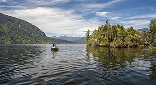
Lake Brunner is the largest lake in the West Coast Region of New Zealand, located 31 km (19 mi) southeast of Greymouth. The main settlement, Moana, is on its northern shore. It is an important settlement and waystation for local Māori. The first Europeans in the area were loggers, and sawmills were an important early industry. Being several kilometres inland from the coast road, it is less frequently visited by tourists than many of the West Coast's scenic highlights, but it is becoming increasingly popular, in part due to its reputation for fishing.

Kakahi ) is a small King Country settlement about 10 kilometres (6.2 mi) up the Whanganui River from Taumarunui, New Zealand. Founded as a sawmill town, it takes its name from the Māori word for the New Zealand freshwater mussel.
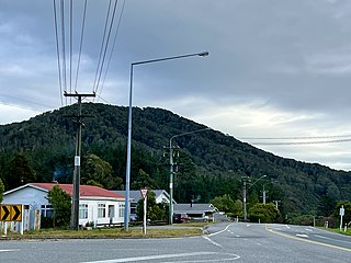
Ngahere is a locality in the Grey District of the West Coast of New Zealand's South Island. The 2013 New Zealand census gave the population of Ngahere and its surrounding area as 363, an increase of 5.2% or 18 people since the 2006 census. Ngahere is located on the south bank of the Grey River, and State Highway 7 and the Stillwater–Westport Line (SWL) railway pass through the village.
The Ross Branch, officially known as the Hokitika Line since 2011, and previously as the Hokitika Industrial Line, is a branch line railway that forms part of New Zealand's national rail network. It is located in the Westland District of the South Island's West Coast region and opened to Hokitika in 1893. A further extension to Ross operated from 1909 until 1980.

Ruatapu is a small town in the Westland District in the West Coast region of the South Island of New Zealand. The town's name stems from Ruatapu, a figure in Māori mythology. The town is located on a narrow strip of land between the Tasman Sea and Lake Mahinapua, a shallow lake that was originally a coastal lagoon. State Highway 6 runs through Ruatapu, connecting it to the nearby towns of Hokitika and Ross. The town's economy is based upon agriculture, as well as a large sawmill, operated by Westco Lagan, which mills Radiata Pine for further processing in Christchurch.
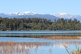
Lake Mahinapua is a shallow lake on the West Coast of New Zealand's South Island. Once a lagoon at the mouth of the Hokitika River, it became a lake when the river shifted its course. Lake Māhinapua was the site of a significant battle between Ngāi Tahu and Ngāti Wairangi Māori, and is regarded by them as a sacred site where swimming and fishing are prohibited. In European times it was part of an inland waterway that carried timber and settlers between Hokitika and Ross until the building of the railway. Today it is protected as a scenic reserve for boating, camping, and hiking.

Whataroa is a small township in southern Westland on the West Coast of New Zealand's South Island. It is located on alluvial flats to the west of the Whataroa River. State Highway 6 passes through Whataroa on its route from Ross to Franz Josef / Waiau. Hari Hari is 31 kilometres (19 mi) to the north-east, and Franz Josef is 32 km to the south-west.
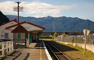
Stillwater is a town in the South Island of New Zealand east of Greymouth on the banks of the Grey River, at the confluence with the Arnold River, in the Grey District of the West Coast, next to Brunner. There is also a Stillwater, Auckland in the North Island.
Makaraka is an outer suburb of Gisborne, in New Zealand's North Island, located in the west of the city. The suburb features Gisborne's horse-racing circuit, Makaraka Racecourse. It is part of the statistical area of Makaraka-Awapuni, which is covered at Awapuni.

The Arnold River is a river on the West Coast of New Zealand's South Island. It is the outflow of Lake Brunner, which it links with the Grey River at Stillwater. The Arnold River flows northwest for 20 kilometres (12 mi), joining the Grey immediately above the town of Brunner, some 15 kilometres (9 mi) from the Tasman Sea. It is a popular spot for whitewater kayaking and trout fishing.

Ikamatua is a small village on the West Coast of the South Island in New Zealand. Its name translates literally as ika (fish) and matua (mature/parent). It may be a contraction of Te Ika-a-matua, fish of my ancestor.

Courtenay is a settlement in inland Canterbury, New Zealand. It was once important as a place where the Waimakariri River could be forded and was a coach stop on the way to the West Coast. Its decline began when the Midland Line was routed via the nearby Kirwee.

The Kokiri Tramway was a bush tramway with a gauge of 1,067 mm near Kokiri on the Arnold River in the west of New Zealand's South Island.

Taringamotu Tramway, nicknamed Taringamotu Express, was a bush tramway near Oruaiwi, also known as Waituhi, a settlement in the valley of Taringamotu in the Manawatū-Whanganui region of New Zealand's North Island. It operated from 1910 to the mid 1960s.

The Mountain Rimu Timber Company owned and operated a bush tramway near Mamaku, south of the Kaimai Range near Rotorua in the Bay of Plenty Region of the North Island of New Zealand. The tramway, with a track gauge of 3+1⁄2 feet (1,067 mm), was used from approximately 1898, to at least 1935.

Stuart and Chapman's bush tramway, Rimu was a 20 kilometres (12 mi) long bush tramway with a gauge of probably 2-foot 6-inch (762 mm) at Seddon's Terrace Sawmill in Rimu, New Zealand. It ran south of Ross to the Lake Ianthe area. It was used from at least 1899 to 1962.
Waimiha is a rural community in the Ruapehu District and Manawatū-Whanganui region of New Zealand's North Island.

Ongarue is a rural community in the Ruapehu District and Manawatū-Whanganui region of New Zealand's North Island. It is located south of Te Kūiti and Waimiha, and north of Taumarunui. It is in meshblock 1041902, which had a population of 54 in 2013.
Mackaytown is a settlement in the Hauraki District and Waikato region of New Zealand's North Island, located at the north-western end of the Karangahake Gorge just south of Paeroa.

