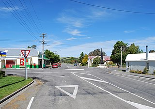
Moana is a small town in the West Coast Region of the South Island of New Zealand. It is situated on the northern shore of Lake Brunner, and is beside the outflow of the lake into the Arnold River.[3][4] There is a pedestrian suspension bridge crossing the Arnold from the town to access the lake shore across the river, with some short easy bush walks on each side.
The town has a permanent population of less than 100, but is a popular location for summer tourism. There are around 300 holiday homes and a camping ground.[5]
The town's main tourist attractions are the panoramic views and water sport opportunities arising from its position on the shores of Lake Brunner. The Midland Linerailway passes through Moana; the TranzAlpine tourist passenger train passes through once in each direction daily, and freight trains of coal operate more frequently.
In May 2013, Moana became one of the first places in New Zealand to get 4G wireless broadband.[6]
Demographics
Moana is described by Statistics New Zealand as a rural settlement and covers 1.16km2 (0.45sqmi).[1] It had an estimated population of 80 as of June 2024,[2] with a population density of 69 people per km2. Moana is part of the larger Lake Brunner statistical area.
Before the 2023 census, the settlement had a smaller boundary, covering 0.58km2 (0.22sqmi).[1] Using that boundary, Moana had a population of 57 at the 2018 New Zealand census, a decrease of 9 people (−13.6%) since the 2013 census, and a decrease of 6 people (−9.5%) since the 2006 census. There were 30 households, comprising 33 males and 27 females, giving a sex ratio of 1.22 males per female. The median age was 58.4 years (compared with 37.4 years nationally), with 6 people (10.5%) aged 15 to 29, 33 (57.9%) aged 30 to 64, and 18 (31.6%) aged 65 or older.
Ethnicities were 89.5% European/Pākehā, 10.5% Māori, 5.3% Pasifika, and 5.3% other ethnicities. People may identify with more than one ethnicity.
Although some people chose not to answer the census's question about religious affiliation, 52.6% had no religion, 36.8% were Christian, and 5.3% were Buddhist.
Of those at least 15 years old, 9 (15.8%) people had a bachelor's or higher degree, and 9 (15.8%) people had no formal qualifications. The median income was $33,900, compared with $31,800 nationally. 6 people (10.5%) earned over $70,000 compared to 17.2% nationally. The employment status of those at least 15 was that 27 (47.4%) people were employed full-time, and 12 (21.1%) were part-time.[7]
Lake Brunner statistical area
Lake Brunner statistical area, which also includes Gloriavale, covers 1,301.70km2 (502.59sqmi)[1] and had an estimated population of 1,250 as of June 2024,[8] with a population density of 0.96 people per km2.
Lake Brunner had a population of 1,065 at the 2018 New Zealand census, an increase of 147 people (16.0%) since the 2013 census, and an increase of 312 people (41.4%) since the 2006 census. There were 186 households, comprising 531 males and 534 females, giving a sex ratio of 0.99 males per female. The median age was 20.4 years (compared with 37.4 years nationally), with 444 people (41.7%) aged under 15 years, 213 (20.0%) aged 15 to 29, 330 (31.0%) aged 30 to 64, and 75 (7.0%) aged 65 or older.
Ethnicities were 95.8% European/Pākehā, 4.5% Māori, 0.8% Pasifika, 1.7% Asian, and 1.7% other ethnicities. People may identify with more than one ethnicity.
The percentage of people born overseas was 7.0, compared with 27.1% nationally.
Although some people chose not to answer the census's question about religious affiliation, 26.8% had no religion, 68.2% were Christian and 0.3% had other religions.
Of those at least 15 years old, 78 (12.6%) people had a bachelor's or higher degree, and 90 (14.5%) people had no formal qualifications. The median income was $25,900, compared with $31,800 nationally. 51 people (8.2%) earned over $70,000 compared to 17.2% nationally. The employment status of those at least 15 was that 357 (57.5%) people were employed full-time, 87 (14.0%) were part-time, and 6 (1.0%) were unemployed.[9]
Education
Lake Brunner School is a coeducational full primary (years 1–8) school with a roll of 65 students as of November 2024.[10][11] Rotomanu School closed and merged into this school in 2005.[12]
Railway station
Moana Railway Station
In 1886, the New Zealand Midland Railway Company entered a contract with the Government for the construction of 376 kilometres (234mi) of railway between Christchurch and Nelson via Brunnerton (later Brunner) over a ten year period. The line was to be built and operated by private enterprise. In November 1892, the company opened the railway from Brunnerton, but at that stage Moana was only a flag station. By March 1894, the railway had reached Jacksons. However, in 1895 the company collapsed. In May 1895 the Government seized the company's assets on the grounds that the contract had expired with the works incomplete. The Government eventually completed the works under the Railways Construction and Land Act 1881.[13]
The opening of the railway to Moana enabled settlement by Pākeha and establishment of timber mills in the local area. By June 1895 a 140 metres (460ft) siding was being operated at Moana station by the Lake Brunner Sawmill Company. The date of construction of the original Moana railway station building is not known, but by 1895 the station had a 61 metres (200ft) long platform and 240 metres (790ft) siding.[13]
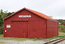
Railway shed in Moana (April 2021)
On 16 April 1926, the station building was destroyed in a fire. A replacement building was constructed in the same year. The replacement was to the standard type A design, from the family of standard railway station designs prepared by Railways architect George Troup.[14]
The Moana Railway Station is listed as a Category 1 Historic Place by Heritage New Zealand. It is the only type A station building still remaining that is complete with its associated sidings and goods sheds.[13] Heritage New Zealand has also given a Category 1 listing to the Moana Railway Station Historic Area comprising the station building, a footbridge, the goods shed and the former station master’s house (now used as a cafe).[15][16]
National Park is a small town on the North Island Central Plateau in New Zealand. Also known as National Park Village, it is the highest urban township in New Zealand, at 825 metres. The village has great views of Mount Tongariro, Mount Ngauruhoe, and Mount Ruapehu.
Murchison is a town in the Tasman Region of the South Island of New Zealand. It is near the western end of the "Four Rivers Plain", at the confluence of the Buller River and the Mātakitaki River. The other two rivers are the Mangles River, and the Matiri River. It is a rural service town for the surrounding mixed farming district, approximately halfway between Westport and Nelson. Murchison was named after the Scottish geologist Roderick Murchison, one of the founders of the Royal Geographical Society.
Drury is a rural town near Auckland, in northern New Zealand. Located 36 kilometres to the south of Auckland CBD, under authority of the Auckland Council. Drury lies at the southern border of the Auckland metropolitan area, 12 kilometres to the northeast of Pukekohe, close to the Papakura Channel, an arm of the Manukau Harbour.
Waharoa is a rural community in the Waikato region of New Zealand's North Island. It is located 7 km north of Matamata, and is part of the Matamata-Piako District. It is located at the junction of the Kinleith Branch railway and the East Coast Main Trunk Railway. State Highway 27 runs through the town, which is serviced by several shops and cafes and by a petrol station. Matamata Airport is just over 3 km (1.9 mi) north of Waharoa.
Mangaweka is a township on State Highway One (SH1) in the Manawatū-Whanganui region of the North Island of New Zealand. It is located between Taihape to the north and Hunterville to the south, has a population of just under 200. The Rangitīkei River, adjacent to the township, is popular for rafting, kayaking, fishing and swimming.
Hawarden is a small town in the Canterbury region of New Zealand's South Island. It is located near Waikari, just off State Highway 7.
Pukawa or Pukawa Bay is a bay and a small township on the southern shores of Lake Taupō on New Zealand's North Island. It is off State Highway 41 between Turangi and Taumarunui, in the Taupō District and Waikato region.
Taupiri is a small town of about 500 people on the eastern bank of the Waikato River in the Waikato District of New Zealand. It is overlooked by Taupiri mountain, the sacred burial ground for the Waikato tribes of the Māori people, located just to the north.
Wairau Valley is the valley of the Wairau River in Marlborough, New Zealand and also the name of the main settlement in the upper valley. State Highway 63 runs through the valley. The valley opens onto the Wairau Plain, where Renwick and Blenheim are sited. The Alpine–Wairau Fault runs along the length of the valley.
Hinuera is a settlement in the Waikato Region of New Zealand's North Island. It is located along State Highway 29, approximately halfway between the cities of Hamilton and Tauranga. It also contains the Hinuera cliffs along State Highway 29.
Walton is a settlement in New Zealand. It is sited at the junction of Walton Road and Morrinsville Walton Road, in the Central Waikato Region.
Ōhaupō is a rural community in the Waipa District and Waikato region of New Zealand's North Island. It is located on State Highway 3, about halfway between Hamilton and Te Awamutu.
Waimana is a rural valley in the Whakatāne District and Bay of Plenty Region of New Zealand's North Island. It is located in the northern Te Urewera. Waimana River, originally known as Tauranga River, runs through the valley, joining the Ohinemataroa River one kilometre south-west of Tāneatua.
Moana is one of the suburbs of Nelson, New Zealand.
Ōhau is a village and semi-rural community in the Horowhenua District and Manawatū-Whanganui region of New Zealand's North Island. It is located just south of Levin on State Highway 1.
Poukawa is a rural community in the Hastings District and Hawke's Bay Region of New Zealand's North Island.
Tuai is a village and rural community located around Lake Whakamarino, in the Wairoa District of the Hawke's Bay Region, on New Zealand's North Island.
Rukuhia is a rural community in the Waipa District and Waikato region of New Zealand's North Island.
Eureka is a rural settlement in the Waikato District and Waikato region of New Zealand's North Island. It is located on State Highway 26, and is surrounded by dairy farmland on a flat plain.
Lower Moutere is a settlement in the Tasman District of New Zealand's upper South Island. It is a farming community it the Lower Moutere valley, 6 km (3.7 mi) from Motueka close to the Moutere Inlet.
This page is based on this Wikipedia article Text is available under the CC BY-SA 4.0 license; additional terms may apply. Images, videos and audio are available under their respective licenses.