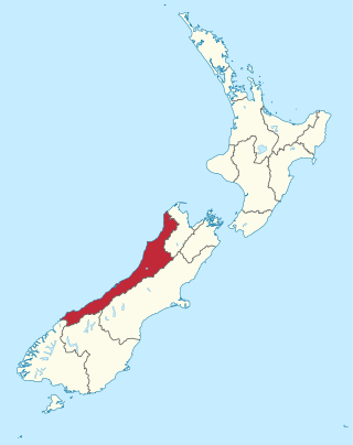
The West Coast is a region of New Zealand on the west coast of the South Island. It is administered by the West Coast Regional Council, and is known co-officially as Te Tai Poutini. It comprises the territorial authorities of Buller District, Grey District and Westland District. The principal towns are Westport, Greymouth and Hokitika. The region, one of the more remote areas of the country, is also the most sparsely populated. With a population of just 32,900 people, the West Coast is the least populous region in New Zealand. The population in the region grew by 0.4% over the year to July 2023.

The Awarau River, usually known as Larry's Creek is located within the South Island of New Zealand. The river is about 27 kilometres (17 mi) long and runs northwest from its headwaters in the Victoria Range to its confluence with the Inangahua River north of Reefton. It also drains part of the Brunner Range and there was a track along that range linking to Lyell by 1901, though none existed in 1874. A track also ran south over Kirwan Hill to the Montgomerie River.
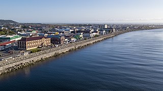
Greymouth is the largest town in the West Coast region in the South Island of New Zealand, and the seat of the Grey District Council. The population of the whole Grey District is 14,250, which accounts for 43% of the West Coast's inhabitants. The Greymouth urban area had an estimated population of 8,340. A large proportion of the District, 65%, is part of the Conservation Estate owned and managed by the Department of Conservation making Greymouth a natural centre for walkers and trampers.

Reefton is a small town in the West Coast region of New Zealand, some 80 km northeast of Greymouth, in the Inangahua River valley. Ahaura is 44 km south-west of Reefton, Inangahua Junction is 34 km to the north, Maruia is 63 km to the east, and the Lewis Pass is 66 km to the south-east.

Inangahua is a small settlement in the northwest of New Zealand's South Island. It consists of three settled areas: Inangahua Junction at the confluence of the Inangahua and Buller Rivers, 34 kilometres (21 mi) north of Reefton and 46 kilometres (29 mi) southeast of Westport; Inangahua Landing, 10 km further up the Inangahua River; and Inangahua township, 2 km east of the Junction. Murchison is 52 kilometres (32 mi) further east. After the 1968 Inangahua Earthquake, most of the inhabitants left the area or shifted to the township, which is now the population centre and known simply as Inangahua.

The Stillwater Ngākawau Line (SNL), formerly the Stillwater–Westport Line (SWL) and the Ngakawau Branch, is a secondary main line, part of New Zealand's national rail network. It runs between Stillwater and Ngakawau via Westport on the West Coast of the South Island. It was one of the longest construction projects in New Zealand's history, with its first section, at the south end, opened in 1889, and the beginnings of the Ngākawau Branch, at its Westport end, in 1875. The full line was completed in 1942. The only slower railway projects were Palmerston North to Gisborne, 1872 to 1942, and the Main North Line to Picton, 1872 to 1945.

The Buller Rugby Union (BRU) is a rugby union province based in the town of Westport, New Zealand. The Buller provincial boundary also includes other notable towns such as Reefton, Karamea, Granity, Charleston, Punakaiki and Murchison.

Lyell is the site of a historic gold mining town in the Buller Gorge in the South Island of New Zealand. It lies on State Highway 6, 18 km (11 mi) northeast of Inangahua.

The Ōhikaiti River is a river of the West Coast Region of New Zealand's South Island. It flows north from Mount Galileo, in the Paparoa Range, paralleling the course of the larger Ōhikanui River which lies two kilometres to the west. The Ōhikaiti empties into the Buller River at the Buller Gorge, 15 kilometres southwest of Westport.
The Ōrangipuku River is a river of the West Coast Region of New Zealand's South Island. It flows north into the southern end of Lake Brunner.

The Waitahu River is a river of the West Coast Region of New Zealand's South Island. It flows generally northwest from its source in the Victoria Range to reach the Inangahua River five kilometres north of Reefton.
The Little Grey River, also known as the Māwheraiti is a river of the West Coast Region of New Zealand. It is a major tributary of the Grey River / Māwheranui which it joins at Ikamatua.

The West Coast Gold Rush, on the West Coast of New Zealand's South Island, lasted from 1864 to 1867.

Shantytown Heritage Park, usually known as Shantytown, is a tourist attraction in the West Coast Region of the South Island of New Zealand. Located 10 kilometres (6.2 mi) south of Greymouth, the Heritage Park opened in 1971 and consists of 30 re-created historic buildings making up a 19th-century gold-mining town. The town is surrounded by native forest, and is one of the region's most popular attractions.

The Westport News is an independently-owned evening newspaper published in Westport, New Zealand. It is published on weekdays, and is one of New Zealand's smallest independent newspapers. The Westport News is distributed from Karamea in the north to Punakaiki in the south and as far inland as Reefton.

Inangahua County was one of the counties of New Zealand on the South Island.

Blacks Point Museum is a museum in Blacks Point, near Reefton on the West Coast of the South Island of New Zealand.

Greymouth Central is the central business district of Greymouth on the West Coast of New Zealand, which also contains residential housing.

The School of Mines in Reefton, New Zealand (1887–1970) was one of a number of mining schools set up to teach the science of mining during the 19th century gold rush. Like the Thames School of Mines it is a Heritage New Zealand Category 1 listed historic building.
Reefton Hospital is a hospital in Reefton on the West Coast of New Zealand. It was founded in 1872 and its closure was announced in 2024.
