Conns Creek Branch

Last updated

Conns Creek Branch
Map

The Conns Creek Branch was a 2.7 kilometre (1.7 mile) branch line railway in the West Coast region of New Zealand's South Island. It diverged from the Seddonville Branch at Waimangaroa and followed the southern bank of the Waimangaroa River to the line's terminus at Conns Creek at the foot of the Denniston Incline. The line operated from 1877 until 1967 and existed for the sole purpose of conveying coal from mines to the port of Westport.

Contents

Construction

Construction of the Seddonville Branch railway from Westport to Seddonville had begun in 1874. In September 1875 the Wellington Coal Mining Company called for tenders for a private line from a junction with the Seddonville branch at Waimangaroa to a site 1.6 kilometres (1 mile) up the Waimangaroa River adjacent to the company's mine. The Seddonville Branch was completed as far as Waimangaroa on 5 August 1876 and the first portion of the Conns Creek Branch - as far as the Wellington Mine - opened in 1877. [1] A bridge across the river connected the then terminus of the branch on the south bank with the Wellington Mine on the north bank.

In 1877, good quality coal was found high on the Mount Rochfort Plateau and the Westport Colliery Company was formed to exploit it. Tenders to extend the Wellington Coal Mining Company's railway by 1.1 kilometres (0.7 miles), and build the Denniston Incline, closed on 30 April 1878. The extension to the new terminus at Conns Creek at the foot of the Denniston Incline was ready for running in February 1879, [2] and in April 1880 the Denniston Incline began operation. [3]

Ownership

Ownership of different parts of this short branch line changed many times.

The lower 1.6 kilometre (1 mile) section from Waimangaroa was owned by the Wellington Coal Mining Company from the line's opening in 1877 [4] until 1880, when the company folded. The line was then bought by the Koranui Coal Mining Company, which was building the Koranui Incline from the north bank of the Waimangaroa River, adjacent to the Wellington Mine, up Simms Spur to access its mine on Mt Frederick. This lower part of the line was bought by the Union Steam Ship Company of New Zealand on 1 August 1885, [5] and then by the Westport Coal Company (which operated the nearby Denniston Incline) in February 1887. [6] Prior to 1887, the Westport Coal Company had to pay high fees to carry coal over this part of the line, first to the Wellington Coal Mining Company and Koranui Coal Mining Company, then to the Union Steam Ship Company; ownership released the company from this difficulty.

The upper 1.1 kilometre (0.7 mile) section to Conns Creek was owned by the Westport Colliery Company (which was reformed into the Westport Coal Company in 1881) from its opening in 1879 until 1948.

In 1948, the whole 2.7 kilometre (1.7 mile) Conns Creek Branch was taken over by the New Zealand State Mines Department, [7] and on 25 September 1958 ownership passed to New Zealand Railways. [8]

Operation

The Conns Creek Branch was operated throughout its life by the New Zealand Railways Department (NZR), which also supplied all locomotives and rolling stock. [4] It was a steep line, with a ruling grade of 1 in 37. [9]

Motive power on the branch was always provided by steam locomotives. Traffic other than coal being conveyed to the harbour in Westport was insignificant. At the start of the 20th century, four trains operated each way daily; these were initially mixed trains as provisions were made to convey passengers (a passenger carriage attached to each train). These were removed in 1931 and the line became goods only.

For most of its life, essentially all traffic on the Conns Creek Branch was to or from the Denniston Incline. The Wellington Coal Mining Company's mine was unsuccessful and closed in 1880. [4] From October 1882 [10] until the beginning of 1887, [11] coal from the Koranui Coal Mining Company's mine on Mount Frederick was brought – via the Koranui Incline and a bridge over the river – to sidings 1.2 kilometres (0.75 miles) up the branch. [12] The Koranui mine and incline closed in 1887.

Traffic was in significant decline by the time the railway passed into NZR ownership, and trains no longer ran through to Westport; a shunting locomotive based in Waimangaroa shuttled wagons up and down the branch, and Seddonville Branch trains took the wagons between Waimangaroa and Westport. The Denniston Incline closed on 16 August 1967, and much of the Conns Creek Branch subsequently closed in November 1967. A one kilometre long portion to a location known as East Backshunt (essentially a long siding from the Waimangaroa yard) [13] was retained to receive coal carried by truck from the Denniston plateau. This operated for only a short time before being closed and the track lifted. [14]

The branch today

Although remnants of closed railways deteriorate and disappear over time due to natural and human activity, some remains of the Conns Creek Branch still exist. Some of the old formation is still visible and a road to the foot of the Denniston Incline follows it for 1.3 kilometres (0.8 miles). At the Conns Creek terminus are a couple of 'Q' class coal wagons (hopper wagons of the type used on the incline), a crane, stone retaining walls, and other relics. From this point, the remains of the incline extend up to Denniston. [15] [16]

Related Research Articles

<span class="mw-page-title-main">Westport, New Zealand</span> Town on the West Coast, New Zealand

Westport is a town in the West Coast region of the South Island of New Zealand. Established in 1861, it is the oldest European settlement on the West Coast. Originally named Buller, it is on the right bank and at the mouth of the Buller River, close by the prominent headland of Cape Foulwind. It is connected via State Highway 6 with Greymouth, 100 kilometres (62 mi) to the south, and with Nelson 222 kilometres (138 mi) in the northeast, via the Buller Gorge. The population of the Westport urban area was 4,250 as of June 2023. The Buller District had a population of 9,670.

Denniston is a small settlement, 15 kilometres east of Westport, on the West Coast of the South Island of New Zealand. It is situated on the Denniston Plateau, 600 metres (2,000 ft) above sea level in the Papahaua Ranges.

<span class="mw-page-title-main">Waimangaroa</span> Town on the West Coast of the South Island of New Zealand

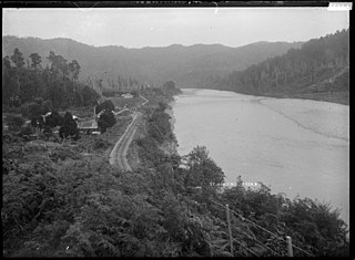
Waimangaroa is a small town located on the West Coast of New Zealand.

<span class="mw-page-title-main">Waimangaroa River</span>

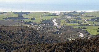
The Waimangaroa River is located on the West Coast of New Zealand.

The Fernhill Branch is a railway line in Otago, New Zealand. It was opened in 1883 and the remaining section formally closed in 2002 although abandoned for ten years. A significant amount of controversy surrounded the ownership status of the line in its early years.

NZR W<sup>B</sup> class

The NZR WB class was a class of tank locomotives that operated in New Zealand. Built in 1898 by the Baldwin Locomotive Works, the twelve members of the class entered service during the first five months of 1899. Eight were withdrawn by the end of 1935, while four others survived with new boilers until the mid-1950s.

<span class="mw-page-title-main">Blackball Branch</span>

The Blackball Branch was a branch line railway of New Zealand's national rail network on the West Coast of the South Island and worked from the 1900s to 1966. It included the Roa Branch, also known as the Roa Incline. Roa was sometimes known as Paparoa.

The Papahaua Range is a mountain range on the West Coast of New Zealand's South Island east of the town of Westport. It is a geological continuation of the Paparoa Range that is south of the Buller River and it runs north from the Buller Gorge to the Mōkihinui River. At its north end, it meets the Glasgow Range.

The Saundersfoot Railway was a Welsh industrial narrow-gauge railway in Pembrokeshire, Wales, built between 1830 and 1834, to connect Saundersfoot harbour to the local coal mines. It opened on 1 March 1834 and within a few years it comprised a small network of over 4 miles (6.4 km) along the coast from Saundersfoot to Wisemans Bridge and on to the collieries at Stepaside and Kilgetty, and later, running inland to Thomas Chapel near Begelly.

<span class="mw-page-title-main">Millerton, New Zealand</span> Place in West Coast, New Zealand

Millerton is a small settlement in the northwestern South Island of New Zealand in the West Coast region. It is in the Papahaua Ranges, around 33 kilometres by road north of Westport, via SH67 from Westport to Karamea.

The Rewanui Branch, sometimes referred to as the Rewanui Incline and known as the Point Elizabeth Branch in its early years, was a branch line railway located in the West Coast region of New Zealand's South Island. It branched from the Midland Line near its western terminus in Greymouth and ran up to Rewanui in the Paparoa Ranges. The branch closed in 1985 but the first six kilometres to Runanga remain in operation as part of the Rapahoe Branch.

<span class="mw-page-title-main">Seddonville Branch</span>

The Seddonville Branch, later truncated as the Ngākawau Branch, is a branch line railway in the West Coast region of New Zealand's South Island. Construction began in 1874 and it reached its terminus at the Mokihinui Mine just beyond Seddonville in 1895. In 1981 it was closed past Ngākawau and effectively became an extension of the Stillwater–Westport Line, since formalised as the Stillwater–Ngākawau Line.

<span class="mw-page-title-main">Seddonville</span> Place in West Coast, New Zealand

Seddonville is a lightly populated locality on the West Coast of New Zealand's South Island. It is most famous for the historical role it played in New Zealand's coal mining industry.

<span class="mw-page-title-main">Mōkihinui River</span> River in New Zealand

The Mōkihinui River is a river located on the West Coast of New Zealand's South Island, about 40 kilometres north of Westport. Meridian Energy had proposed the Mokihinui Hydro project on the river in 2007 but it was cancelled in May 2012. In 2019, it was announced that 64,400 ha of land in the Mōkihinui River catchment, including 15 km (9.3 mi) of river bed, would be added to Kahurangi National Park.

Summerlea is a lightly populated locality on the West Coast of New Zealand's South Island.

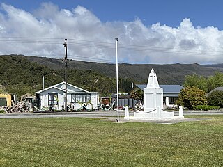
Sergeants Hill is a lightly populated locality in the West Coast region of New Zealand's South Island. It is situated in a rural setting on the eastern outskirts of Westport in the Buller District.

<span class="mw-page-title-main">Stockton Mine</span>

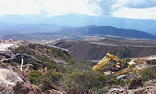
Stockton Mine, on the Stockton Coal Field, is New Zealand's largest opencast mining operation. The entrance to the mine is at the former settlement of Stockton.
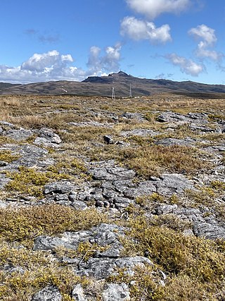
The Koranui Incline was an inclined tramway on the West Coast of the South Island of New Zealand that, for four years from late 1882 to the end of 1886, brought coal from a mine high on Mt Frederick down to a railway line near sea level.

The Rockies Incline was an inclined tramway on the West Coast of the South Island of New Zealand that for ten years from 1925 to 1935 brought coal from the Westport Main Coal Company’s mine on the Millerton-Stockton plateau down to the Westport to Seddonville railway line near sea level.

<span class="mw-page-title-main">Charming Creek Tramway</span>

The Charming Creek Tramway was a 9 kilometres (5.6 mi) long private bush tramway at Ngakawau in Buller District on the West Coast in New Zealand. It was used from 1903 or 1905 to 1958.

References

Citations

  1. Prebble, Bill (Editor) (2008). Denniston's Incline: Coal from the Clouds. New Zealand Railway and Locomotive Society Incorporated. p. 20. ISBN   978-0-908573-84-4.{{cite book}}: |first1= has generic name (help)
  2. Prebble, B (Ed) (2008). p. 19.
  3. Prebble, B (Ed) (2008). p. 23.
  4. 1 2 3 Prebble, B (Ed) (2008). p. 16.
  5. Grey River Argus Volume XXXI, Issue 5226, 26 June 1885, p. 2.
  6. Grey River Argus Volume XXXIV, Issue 5830, 26 February 1887, p. 4.
  7. Prebble, B (Ed) (2008). p. 29.
  8. Prebble, B (Ed) (2008). p. 35.
  9. Prebble, B (Ed) (2008). p. 64.
  10. Grey River Argus Volume XXVI, Issue 4433, 7 November 1882, p. 2.
  11. New Zealand Tablet Volume XIV, Issue 48, 25 March 1887, p. 9.
  12. Petchey, P G (2007). Denniston. Archaeological Survey Report for the Department of Conservation, West Coast Conservancy. Southern Archaeology Ltd, Dunedin. p. 31. Retrieved 14 December 2016.
  13. Churchman & Hurst 2001, p. 196-197.
  14. Prebble, B (Ed) (2008). p. 40.
  15. Leitch & Scott 1995, p. 54.
  16. Petchey, P G (2007). p. 32.

Bibliography

  • Churchman, Geoffrey B; Hurst, Tony (2001) [1990, 1991]. The Railways of New Zealand: A Journey through History (Second ed.). Transpress New Zealand. ISBN   0-908876-20-3.
  • Leitch, David; Scott, Brian (1995). Exploring New Zealand's Ghost Railways (1998 ed.). Wellington: Grantham House. ISBN   1-86934-048-5.
  • Meyer, R. J. (1971). Coaling From The Clouds: The Mount Rochfort Railway and the Denniston Incline. Wellington: New Zealand Railway and Locomotive Society.
  • Prebble, Bill (Editor) (2008). Denniston's Incline: Coal from the Clouds. Wellington: New Zealand Railway and Locomotive Society. ISBN   978-0-908573-84-4.{{cite book}}: |first1= has generic name (help)
  • Mulligan, Barbara (2000). New Zealand Rail Trails: A Guide to 42 Ghost Lines. Wellington: Grantham House Publishing. pp. 81–83. ISBN   978-1-86934-126-8.