
The Main South Line, sometimes referred to as part of the South Island Main Trunk Railway, is a railway line that runs north and south from Lyttelton in New Zealand through Christchurch and along the east coast of the South Island to Invercargill via Dunedin. It is one of the most important railway lines in New Zealand and was one of the first to be built, with construction commencing in the 1860s. At Christchurch, it connects with the Main North Line to Picton, the other part of the South Island Main Trunk.
The Tokanui Branch, also known as the Seaward Bush Branch, was a branch line railway located in Southland, New Zealand. It diverged from the Bluff Branch south of the main railway station in Invercargill and ran for 54 kilometres in a southeasterly direction. Construction began in 1883 and it operated until 1966.
The Outram Branch was a branch line railway near Dunedin, Otago, that operated from 1877 to 1953 and formed part of New Zealand's national rail network.
The Ngapara and Tokarahi Branches were two connected railway branch lines in northern Otago, New Zealand, part of the national rail network. The Ngapara Branch opened in 1877 and almost all of it closed in 1959; the remaining few kilometres, called the Waiareka Industrial Line, were removed in 1997. The Tokarahi Branch branched off the Ngapara Branch. It operated from 1887 until 1930 and was originally known as the Livingstone Branch, though it never progressed beyond Tokarahi to Livingstone. In early 2008 there is a proposal to reinstate the first 4.5 km of the Ngapara Branch.

The Waikaia Branch, also known as the Switzers Branch, was a branch line railway in Southland, New Zealand. Proposed as early as the 1870s, it was not opened until 1909 and was operated by the New Zealand Railways Department for half a century until its closure in 1959.
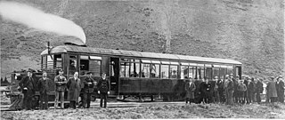
The NZR RM class Clayton steam rail motor was a unique railcar that was operated by New Zealand Railways (NZR) for New Zealand's national rail network and one of only two steam railcars to operate in New Zealand - the other being 1925's RM class Sentinel-Cammell.

The NZR RM class Edison battery-electric railcar was a railcar that ran in Canterbury, New Zealand for eight years. It was built for New Zealand Railways (NZR) as a prototype for battery-electric railcars. While the railcar, classified "RM 6", was considered the first successful railcar in New Zealand, it was later destroyed in a fire, and battery-electric traction for railcars was not developed further in New Zealand. Two other classes of battery-electric locomotives were introduced about the same time as RM 6, the E class of 1922 and the EB class of 1925.

The Otago Central Railway (OCR) or in later years Otago Central Branch Railway, now often referred to as the Taieri Gorge Railway, was a secondary railway line in Central Otago, in the South Island of New Zealand.
The Fairlie Branch was a branch line railway in southern Canterbury which formed part of New Zealand's national railway network. Construction began in 1874, and at its farthest extent, it terminated just beyond Fairlie in Eversley. Its closure came in 1968, but a portion remains open in Pleasant Point as the Pleasant Point Museum and Railway.
Ngapara is a locality in the north Otago region of New Zealand's South Island. It is located in a rural setting 25 km inland from Oamaru. The name of Ngapara is derived from the Māori word for the "tables" or plateaus of limestone in the area.
The Kurow Branch was part of New Zealand's national rail network. In the North Otago region of the South Island, it was built in the 1870s to open up the land behind Oamaru for development, and closed in 1983.
The Roxburgh Branch was a branch line railway built in the Otago region of New Zealand's South Island that formed part of the country's national rail network. Originally known as the Lawrence Branch, it was one of the longest construction projects in New Zealand railway history, beginning in the 1870s and not finished until 1928. The full line was closed in 1968.
Hakataramea, spelt Hakateramea in some older sources, is a rural village located in the southern Canterbury region of New Zealand's South Island. It is in the Waimate District and sits on the north bank of the Waitaki River at its confluence with the Hakataramea River.

The Whitecliffs Branch was an 18.4 kilometres (11.4 mi) long branch line railway that formed part of New Zealand's national rail network in the Canterbury region of the South Island. It was more industrial than the many rural branches on the South Island's east coast whose traffic primarily derived from agriculture, and it operated from 1875 until 1962.
The Waiau Branch was a branch line railway in the northern Canterbury region of New Zealand's South Island. Known as the Great Northern Railway for its first few decades of life, the Waiau Branch was seen as part of a main line north but was ultimately superseded by a coastal route. Opened in stages from 1882 to 1919, the line closed in 1978 but a portion has been retained as the Weka Pass Railway.

The Seddonville Branch, later truncated as the Ngākawau Branch, is a branch line railway in the West Coast region of New Zealand's South Island. Construction began in 1874 and it reached its terminus at the Mokihinui Mine just beyond Seddonville in 1895. In 1981 it was closed past Ngākawau and effectively became an extension of the Stillwater–Westport Line, since formalised as the Stillwater–Ngākawau Line.
Studholme is a locality in southern Canterbury in New Zealand's South Island. It is named after Michael Studholme, a pioneer European settler who arrived in the area in 1854.

The Waihao River is a natural watercourse in the Canterbury region of New Zealand's South Island. It flows into the Wainono Lagoon near Studholme.
Waimate is a town in Canterbury, New Zealand, and the seat of Waimate District. It is situated just inland from the eastern coast of the South Island. The town is reached via a short detour west when travelling on State Highway One, the main North/South road. Waimate is 45.7 km south of Timaru, Canterbury's second city, 20 km north of the Waitaki River, which forms the border between Canterbury and the Otago province to the south and 47.5 km north of Oamaru, the main town of the Waitaki District.
