Fairlie Branch

Last updated

Fairlie Branch
Overview
StatusPartly Closed
Owner Railways Department
Locale Canterbury, New Zealand
Termini
  • Washdyke
  • Eversley
Stations15
Service
Type Heavy Rail
System New Zealand Government Railways (NZGR)
Operator(s) Railways Department
History
Opened1875 - 1884 (1875 - 1884)
Closed1968 (1968)
Technical
Line length58.2 km (36.2 mi)
Number of tracksSingle
CharacterRural
Track gauge 3 ft 6 in (1,067 mm)
Route map

Contents

km
 
BSicon CONTgq.svg
BSicon ABZq+l.svg
BSicon eHSTq.svg
BSicon CONTfq.svg
0.00
Washdyke
BSicon exl-HST.svg
BSicon lENDE@G.svg
BSicon exSTR.svg
BSicon RP2+l.svg
14.67
Racecourse
BSicon exHST.svg
BSicon RP2.svg
21.43
Cartwrights
BSicon exHST.svg
BSicon RP2.svg
26.75
Levels
BSicon STRc2 grey.svg
BSicon exHST.svg
BSicon RP23+n.svg
10.00
Waitawa
BSicon WASSER+4.svg
BSicon STRc2 grey.svg
BSicon exBUE.svg
BSicon RP23+1.svg
BSicon STRc4 grey.svg
BSicon WABZgr.svg
BSicon RP2s+1.svg
BSicon STRc4 grey.svg
BSicon KHSTxe.svg
BSicon lDAMPF.svg
14.42
Pleasant Point
BSicon WASSER.svg
BSicon RP2.svg
BSicon exHST.svg
21.89
Sutherlands
BSicon WASSER.svg
BSicon RP2.svg
BSicon exHST.svg
29.89
Cave
BSicon WASSER.svg
BSicon RP2.svg
BSicon exHST.svg
35.38
Ma Waro
BSicon WABZgl.svg
BSicon RP22+n.svg
BSicon hKRZWae2.svg
BSicon STRc3 grey.svg
BSicon exWBRUCKE1.svg
BSicon WASSERq.svg
BSicon WCONTgeq.svg
BSicon WASSER2.svg
BSicon WSTRc3.svg
BSicon STRc1 grey.svg
BSicon exBUE.svg
BSicon RP22+4.svg
BSicon STRc3 grey.svg
BSicon WSTRc1.svg
BSicon WASSER+4.svg
BSicon STRc1 grey.svg
BSicon exHST.svg
BSicon RP2s+4.svg
41.18
Albury
BSicon WABZgl.svg
BSicon exWBRUCKE1.svg
BSicon RP2oW.svg
BSicon WCONTgeq.svg
BSicon WSHI1l.svg
BSicon exHST.svg
BSicon RP2.svg
42.00
Tengawai
BSicon v-WASSERl.svg
BSicon exhKRZWae.svg
BSicon RP2oW.svg
BSicon WCONTgeq.svg
BSicon exHST.svg
BSicon RP2.svg
47.73
Cricklewood
BSicon exHST.svg
BSicon RP2.svg
52.75
Winscombe
BSicon exHST.svg
BSicon RP2.svg
56.89
Fairlie
BSicon exKHSTe.svg
BSicon exLSTR.svg
BSicon RP2.svg
58.20
Eversley
BSicon exlENDE@F.svg
BSicon exLSTR.svg
85.00
unused formation
Fairlie Branch
Map

The Fairlie Branch (also known as the Eversley Branch) was a branch line railway in southern Canterbury which formed part of New Zealand's national railway network. Construction began in 1874, and at its farthest extent, it terminated just beyond Fairlie in Eversley. Its closure came in 1968, but a portion remains open in Pleasant Point as the Pleasant Point Museum and Railway.

Construction

Proposed in the early 1870s, the local government voted in favour of a branch line from Timaru to Pleasant Point in December 1872 and a construction contract was let in the following March. After a railway act approving the line was passed later in 1873, construction could commence, and it did so on 18 February 1874. The branch left the Main South Line in Washdyke, now a northern suburb of Timaru, and headed northwest towards Pleasant Point. Construction of this 14.42 kilometres (8.96 mi) of railway proceeded without any notable difficulties, opening for service on 24 December 1875 - though trains had been able to run to Pleasant Point as early as two months previously. [1] An extension followed swiftly, and the 27 kilometres (17 mi) addition to Albury opened on 1 January 1877. [2]

After this point, however, construction stalled. On 13 August 1880, the Timaru Chamber of Commerce passed a resolution to pressure the government to call tenders for the construction of the remainder of the line. [3] This was followed by a public meeting in Fairlie on 25 March 1882 that issued the same demand on the government, asserting that the line to Albury was the best paying in New Zealand and an extension would provide more convenient access to much of the freight then conveyed to the Albury terminus. [4] Contracts were soon let, and the next 12 kilometres (7.5 mi) to Winscombe were opened on 24 August 1883. Less than half a year later, the final portion of the line was opened for general traffic to the locale of Eversley, just beyond Fairlie, on 28 January 1884, giving the branch a full length of 58.2 kilometres (36.2 mi). [5] [6] Some sources, including Railways Department publications, incorrectly state this happened on 9 January 1884. [7] The opening of the line was celebrated on 30 January 1884 by a public holiday in Fairlie and environs, and an excursion train ran from Timaru conveying 600-700 passengers for the occasion. This train was double-headed by K 88 Washington and a member of the F class, and it consisted of a guard's van and 14 carriages, some of which were brought down from Christchurch the previous morning to cater for the anticipated large crowd. [5] [8]

There were plans to extend the branch even further to Burkes Pass and the Mackenzie Country. [8] 27 kilometres (17 mi) of formation were made to varying standards of completion, but ultimately no rails were laid and the line's farthest terminus remained Eversley. [9]

Stations

Pleasant Point Station Pleasant Point Railway 1.jpg
Pleasant Point Station

The following stations were located on the Fairlie Branch (in brackets is the distance from Washdyke): [2]

The Fairlie station was destroyed by fire on at least two occasions, first on 13 January 1890 [10] and again on the night of 8 August 1908. [11] [12] After the 1908 fire, the post and telegraph office formerly based at Fairlie station was housed in a temporary building; this too was burnt down in a suspected act of arson on the morning of 20 September 1908. [13]

Operation

The line's reason for existence was to open up farmland in the region behind Timaru and promote rural development. When opened to Pleasant Point, two trains ran each way a day, [9] and while the line had its terminus in Albury, significant traffic was generated by wool and grain being carried by dray to the station from regions further inland. [4] Upon opening to Fairlie, the line's timetable was initially adjusted to the pattern typical of many rural New Zealand branch lines, with a single mixed train carrying both passengers and freight running each way per day. Special freight trains ran as necessary, especially to collect livestock from Pleasant Point. For a period, the line also had its own dedicated passenger train, nicknamed the "Fairlie Flyer", but it perhaps did not live up to its fast-sounding name; by the late 1920s, it was quicker to travel by car between Fairlie and Timaru, which resulted in a decline of traffic that led to the train's cancellation in 1930. From this time, passengers were solely catered for by the daily mixed train. [9]

The line had also started making a loss around this period, and on 1 April 1934, the short section from Fairlie to Eversley was closed. It had always been operated as an extension of the Fairlie yard and its existence had become redundant. The rest of the line entered into a slow demise, with passenger services cut to thrice weekly in 1953; the mixed train operated Mondays, Wednesdays, and Fridays, with solely freight carried on Tuesdays and Thursdays. On 2 November 1953, passenger provisions were cancelled entirely and all services became freight only. [2] With the cessation of the mixed trains, the small locomotive depot in Fairlie closed and the freight trains were operated every weekday morning from Timaru. Intense competition from road traffic posed problems for the line, and what traffic it did retain was mainly due to government subsidies. [9] Despite this, by 1966, the livestock traffic that had been the line's primary cargo was all but non-existent and the decision was soon made to close the line. The date of closure was 2 March 1968 and the occasion was marked by a special return of the Fairlie Flyer, attracting large crowds of locals. [14]

Train and main street of Pleasant Point, South Canterbury, March 1968 Fairlie Flyer's last trip to Timaru in 1968.jpg
Train and main street of Pleasant Point, South Canterbury, March 1968

The branch today

D 16 built in 1878 at the Pleasant Point Museum Pleasant Point Railway & Historical Society (15926118263).jpg
D 16 built in 1878 at the Pleasant Point Museum

Remnants of closed railway lines diminish and disappear as a result of natural and human activity, but some relics from the Fairlie Branch's operating days still exist, most notably the 2.5 kilometres (1.6 mi) of restored trackage still in use by the Pleasant Point Museum and Railway. At Washdyke, the first few hundred metres of the branch were retained as a backshunt and to provide access to an industrial siding, and the track currently remains in place. For much of the line's length from Timaru to Fairlie, the formation can be seen making its way through the rolling countryside, and abutments and piles still stand at the site of some bridges. One bridge itself still stands, near Winscombe. Loading banks still exist at the site of Levels, Waitawa, Sutherlands, and Cave stations. Levels also still possesses its goods shed and Waitawa has the remnants of a platform.

The Fairlie Rail Trail is planned to use the route once used by trains [15] and to start work by 2015.[ needs update ]

The song "Fairlie Flyer" words by Bill Timmings and music by the Picasso Trio, written in the late 1960s, focuses on the branch line and some of its characters such as Martin Fahey, the legendary guard of the 'Fairlie Flyer' to Timaru. The refrain makes reference to the final excursion over the line, also dubbed the 'Fairlie Flyer' and hauled by AB's 718 and 798:

So fireman stoke that engine,steam down that railway track.This train that's leaving Fairlieis never, ever coming back.

Related Research Articles

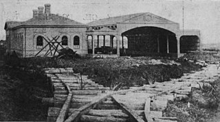
The Tapanui Branch was a railway line located near the border of the regions of Southland and Otago, New Zealand. Although the name suggests that it terminated in Tapanui, its furthest terminus was actually in Edievale. Construction of the line began in 1878 with the first section opened in 1880, and it operated until 1978, when it was destroyed by flooding from the Pomahaka River.

<span class="mw-page-title-main">Main South Line</span> Railway line in New Zealand

The Main South Line, sometimes referred to as part of the South Island Main Trunk Railway, is a railway line that runs north and south from Lyttelton in New Zealand through Christchurch and along the east coast of the South Island to Invercargill via Dunedin. It is one of the most important railway lines in New Zealand and was one of the first to be built, with construction commencing in the 1860s. At Christchurch, it connects with the Main North Line to Picton, the other part of the South Island Main Trunk.

The Tokanui Branch, also known as the Seaward Bush Branch, was a branch line railway located in Southland, New Zealand. It diverged from the Bluff Branch south of the main railway station in Invercargill and ran for 54 kilometres in a southeasterly direction. Construction began in 1883 and it operated until 1966.

The Waimate Branch was a branch line railway built in southern Canterbury, New Zealand to link the Main South Line with the town of Waimate, the centre of the surrounding rural area. It opened in 1877 and operated until 1966; for some of this time, it included an extension to Waihao Downs that was known as the Waimate Gorge Branch or Waihao Downs Branch. When the line closed, Waimate received the dubious distinction of being New Zealand's first major town to lose its railway line.

The Ngapara and Tokarahi Branches were two connected railway branch lines in northern Otago, New Zealand, part of the national rail network. The Ngapara Branch opened in 1877 and almost all of it closed in 1959; the remaining few kilometres, called the Waiareka Industrial Line, were removed in 1997. The Tokarahi Branch branched off the Ngapara Branch. It operated from 1887 until 1930 and was originally known as the Livingstone Branch, though it never progressed beyond Tokarahi to Livingstone. In early 2008 there is a proposal to reinstate the first 4.5 km of the Ngapara Branch.

The Methven Branch was a branch line railway that was part of New Zealand's national rail network in Canterbury. It opened in 1880 and operated until 1976.

The Catlins River Branch was a branch line railway that formed part of New Zealand's national rail network. It ran through the Catlins region in southwestern Otago and was built in sections between 1879 and 1915. It closed in 1971 except for the first four kilometres, which remain open as the Finegand Branch. Along the line was the Hunts Road tunnel, the southernmost tunnel in New Zealand.

<span class="mw-page-title-main">Kingston Branch</span> Railway line in Southland, New Zealand.

The Kingston Branch was a major railway line in Southland, New Zealand. It formed part of New Zealand's national rail network for over a century: construction began in 1864, Kingston was reached in 1878, and it closed in 1979. For much of its life, it was considered a secondary main line rather than a branch line, and in its earlier years, it was sometimes known as the "Great Northern Railway". Today, the southern portion now forms a part of the Wairio Branch and the northernmost 14 kilometres was used by the Kingston Flyer.

The Mossburn Branch was a branch line railway in New Zealand from Lumsden on the Kingston Branch to the town of Mossburn in northern Southland. Construction began in 1879, Mossburn was reached in 1887, and the line closed in 1982. It was operated by the New Zealand Railways Department.

The Donnellys Crossing Section, also known as the Kaihu Valley Railway or Kaihu Branch, was a railway line in Northland, New Zealand. Initially an isolated line of 35.91 kilometres (22.31 mi), it became a branch line when the Dargaville Branch was opened and connected it with the North Auckland Line and the rest of the national rail network in 1943. The branch was closed in 1959.

<span class="mw-page-title-main">NZR RM class (Model T Ford)</span>

The NZR RM class Model T Ford railcar was a type of rail motor that operated on New Zealand's national rail network. Only two were built, classified as RM 4 and RM 5, and they were experimental railcars designed in an attempt to offer improved passenger services on quiet country branch lines that served regions with small populations.

<span class="mw-page-title-main">Pleasant Point Museum and Railway</span>

The Pleasant Point Museum and Railway is a heritage railway located in the small country town of Pleasant Point in southern Canterbury, New Zealand, inland from Timaru.

<span class="mw-page-title-main">New Zealand Railways Department</span> Government agency (1880–1982)

The New Zealand Railways Department, NZR or NZGR and often known as the "Railways", was a government department charged with owning and maintaining New Zealand's railway infrastructure and operating the railway system. The Department was created in 1880 and was corporatised on 1 April 1982 into the New Zealand Railways Corporation. Originally, railway construction and operation took place under the auspices of the former provincial governments and some private railways, before all of the provincial operations came under the central Public Works Department. The role of operating the rail network was subsequently separated from that of the network's construction. From 1895 to 1993 there was a responsible Minister, the Minister of Railways. He was often also the Minister of Public Works.

Albury is a small village in the southern part of the Canterbury region of the South Island of New Zealand. It is inland from Timaru and located on State Highway 8 between Pleasant Point and Fairlie. It is in the Mackenzie Country.

Winscombe is a lightly populated locality in the southern part of the Canterbury region of New Zealand's South Island. It is situated inland from Timaru on State Highway 8 between Pleasant Point and Fairlie. It is located in a very rural setting.

<span class="mw-page-title-main">Seddonville Branch</span>

The Seddonville Branch, later truncated as the Ngākawau Branch, is a branch line railway in the West Coast region of New Zealand's South Island. Construction began in 1874 and it reached its terminus at the Mokihinui Mine just beyond Seddonville in 1895. In 1981 it was closed past Ngākawau and effectively became an extension of the Stillwater–Westport Line, since formalised as the Stillwater–Ngākawau Line.

Washdyke is an industrial suburb in the north of Timaru, in south Canterbury, New Zealand. State Highway 1 passes through Washdyke on the way north out of the city. The northern terminus of State Highway 8 is in Washdyke.

The Wanganui Branch is a 5.00 km branch line railway in the Manawatū-Whanganui region of New Zealand's North Island. It links Wanganui with the Marton - New Plymouth Line (MNPL) at Aramoho and has been open since 21 January 1878, although solely for freight traffic since 7 September 1959. Another branch line diverged from the Wanganui Branch near its terminus, the Castlecliff Branch.

<span class="mw-page-title-main">Thames Branch</span>

The Thames Branch railway line connected Thames, New Zealand, with Hamilton and was originally part of the East Coast Main Trunk railway. Part of the line between Morrinsville and Waitoa remains open and is in use as the Waitoa Branch line, connecting to the Fonterra Dairy Factory at Waitoa.

The Moutohora Branch was a branch line railway that formed part of New Zealand's national rail network in Poverty Bay in the North Island of New Zealand. The branch ran for 78 km approximately North-West from Gisborne into the rugged and steep Raukumara Range to the terminus at Moutohora. Construction started in 1900, and the line was opened to Moutohora on 26 November 1917.

References

Citations

  1. Leitch & Scott 1995, p. 77-78.
  2. 1 2 3 New Zealand Railway and Tramway Atlas, fourth edition, edited by John Yonge (Essex: Quail Map Company, 1993), 24.
  3. "Timaru". North Otago Times. Vol. 28, no. 2558. 14 August 1880. p. 2. Archived from the original on 3 March 2016 via PapersPast.
  4. 1 2 "Timaru". North Otago Times. Vol. 28, no. 3020. 27 March 1882. p. 2. Archived from the original on 3 March 2016 via PapersPast.
  5. 1 2 "Opening of the Railway to Fairlie Creek". Timaru Herald. 31 January 1884. p. 3 via PapersPast.
  6. Churchman & Hurst 2001, p. 185.
  7. For example, see New Zealand Railways Department, Geographical Mileage Table (New Zealand Railways Department: Place of publication within New Zealand unknown, 1957), 19. The previously cited New Zealand Railway and Tramway Atlas also offers the incorrect date.
  8. 1 2 "Timaru". West Coast Times. No. 4531. 31 January 1884. p. 2. Archived from the original on 3 March 2016 via PapersPast.
  9. 1 2 3 4 Leitch & Scott 1995, p. 78.
  10. "A Railway Station Burnt Down". Evening Post. Vol. 39, no. 10. United Press Association. 13 January 1890. p. 2. Archived from the original on 3 March 2016 via PapersPast.
  11. "Railway Station Destroyed". Hawera and Normanby Star. No. 53. 10 August 1908. p. 8. Archived from the original on 3 March 2016 via PapersPast.
  12. "Untitled photographs of station fire". Otago Witness. No. 2811. 26 August 1908. p. 48. Archived from the original on 1 October 2011. Retrieved 11 December 2007 via PapersPast.
  13. "Serious Fire at Fairlie". Evening Post. Vol. 76, no. 71. Press Association. 21 September 1908. p. 7. Archived from the original on 3 March 2016 via PapersPast.
  14. Leitch & Scott 1995, p. 79.
  15. Tollan, Jeff (3 June 2009). "Cycle rail trail to Fairlie mooted". Stuff.co.nz. Retrieved 11 April 2022.

Bibliography

  • Churchman, Geoffrey B; Hurst, Tony (2001) [1990, 1991]. The Railways of New Zealand: A Journey through History (Second ed.). Transpress New Zealand. ISBN   0-908876-20-3.
  • Leitch, David; Scott, Brian (1995). Exploring New Zealand's Ghost Railways (1998 ed.). Wellington: Grantham House. ISBN   1-86934-048-5.
  • Hermann, Bruce J; South Island Branch Lines pp 15,16 (1997, New Zealand Railway & Locomotive Society, Wellington) ISBN   0-908573-70-7
  • Mulligan, Barbara (2000). New Zealand Rail Trails: A Guide to 42 Ghost Lines. Wellington: Grantham House Publishing. pp. 130–134. ISBN   978-1-86934-126-8.