
The Buller River is a river in the South Island of New Zealand. The Buller has the highest flow of any river in the country during floods, though it is only the 13th longest river; it runs for 177 km (110 mi) from Lake Rotoiti through the Buller Gorge and into the Tasman Sea near the town of Westport. A saddle at 710 m (2,330 ft) separates the Buller from the Motupiko River and that is divided from the Wairau River by a 695 m (2,280 ft) saddle, both aligned along the Alpine Fault, as is the top of the Buller valley.

Cape Foulwind is a headland on the West Coast of the South Island of New Zealand, overlooking the Tasman Sea. It is located 11 kilometres (6.8 mi) west of the town of Westport. There is a lighthouse located on a prominent site on the headland. A walkway beginning at the lighthouse carpark traverses the rocky headland to Tauranga Bay and passes close by a colony of New Zealand fur seals. There is limestone quarry in the area, and a cement works operated nearby from 1958 to 2016.
The Tokanui Branch, also known as the Seaward Bush Branch, was a branch line railway located in Southland, New Zealand. It diverged from the Bluff Branch south of the main railway station in Invercargill and ran for 54 kilometres in a southeasterly direction. Construction began in 1883 and it operated until 1966.

The Foxton Branch was a railway line in New Zealand. It began life as a tramway, reopened as a railway on 27 April 1876, and operated until 18 July 1959. At Himatangi there was a junction with the Sanson Tramway, a line operated by the Manawatu County Council that was never upgraded to the status of a railway.
The Onerahi Branch, sometimes known as the Grahamtown Railway, was a branch line railway in the Northland Region of New Zealand. It operated from 1911 until 1933 and linked the city of Whangārei to the nearby harbour in Onerahi.

The Opua Branch or Otiria-Opua Industrial Line, partially still operational as the Bay of Islands Vintage Railway, is a former section of the North Auckland Line in the Northland Region of New Zealand, between Otiria and the Bay of Islands township of Opua. The first section was constructed as a bush tramway in 1867 and converted to a railway in the next decade. Today the railway is partially used by the Bay of Islands Vintage Railway, which runs tourist services between Kawakawa and Te Akeake. The line's centrepiece is the section where it runs down along the main street of Kawakawa.

The Whitecliffs Branch was an 18.4 kilometres (11.4 mi) long branch line railway that formed part of New Zealand's national rail network in the Canterbury region of the South Island. It was more industrial than the many rural branches on the South Island's east coast whose traffic primarily derived from agriculture, and it operated from 1875 until 1962.

The Raetihi Branch was a branch line railway in the central North Island of New Zealand. It formed part of New Zealand's national rail network and operated from 1917 until 1968.

The Te Aro Extension, also known as the Te Aro Branch, was a short branch line railway in Wellington, New Zealand continuing the Wairarapa Line southwards. It operated from 1893 until 1917.

The Main North Line, sometimes referred to as part of the South Island Main Trunk railway, is a railway line that runs north from Christchurch in New Zealand up the east coast of the South Island through Kaikōura and Blenheim to Picton. It is a major link in New Zealand's national rail network and offers a connection with roll-on roll-off ferries from Picton to Wellington. It was also the longest railway construction project in New Zealand's history, with the first stages built in the 1870s and not completed until 1945.

The Stillwater Ngākawau Line (SNL), formerly the Stillwater–Westport Line (SWL) and the Ngakawau Branch, is a secondary main line, part of New Zealand's national rail network. It runs between Stillwater and Ngakawau via Westport on the West Coast of the South Island. It was one of the longest construction projects in New Zealand's history, with its first section, at the south end, opened in 1889, and the beginnings of the Ngākawau Branch, at its Westport end, in 1875. The full line was completed in 1942. The only slower railway projects were Palmerston North to Gisborne, 1872 to 1942, and the Main North Line to Picton, 1872 to 1945.

The East Coast Main Trunk (ECMT) is a railway line in the North Island of New Zealand, originally running between Hamilton and Taneatua via Tauranga, connecting the Waikato with the Bay of Plenty. The ECMT now runs between Hamilton and Kawerau, with a branch line to Taneatua from the junction at Hawkens. The line is built to narrow gauge of 1,067 mm, the uniform gauge in New Zealand. It was known as the East Coast Main Trunk Railway until 2011, when the word "Railway" was dropped.

The Seddonville Branch, later truncated as the Ngākawau Branch, is a branch line railway in the West Coast region of New Zealand's South Island. Construction began in 1874 and it reached its terminus at the Mokihinui Mine just beyond Seddonville in 1895. In 1981 it was closed past Ngākawau and effectively became an extension of the Stillwater–Westport Line, since formalised as the Stillwater–Ngākawau Line.

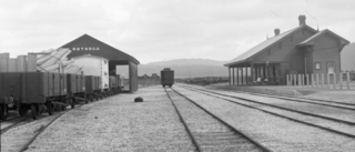
Seddonville is a lightly populated locality on the West Coast of New Zealand's South Island. It is most famous for the historical role it played in New Zealand's coal mining industry.
The Palmerston North–Gisborne Line (PNGL) is a secondary main line railway in the North Island of New Zealand. It branches from the North Island Main Trunk at Palmerston North and runs east through the Manawatū Gorge to Woodville, where it meets the Wairarapa Line, and then proceeds to Hastings and Napier in Hawke's Bay before following the coast north to Gisborne. Construction began in 1872, but the entire line was not completed until 1942. The line crosses the runway of Gisborne Airport, one of the world's only railways to do so since Pakistan's Khyber Pass Railway closed.
The Rotorua Branch is a railway line from Putāruru to Rotorua, in the Waikato and Bay of Plenty regions of the North Island of New Zealand. Construction of the line was commenced by the Thames Valley and Rotorua Railway Company and finished by the Public Works Department (PWD). The complete line, 50.5 kilometres (31.4 mi) in length, opened in two sections; on 24 November 1893 to Tārukenga and the final 8 mi 43 ch (13.7 km) to Rotorua on 8 December 1894.

The Thames Branch railway line connected Thames, New Zealand, with Hamilton and was originally part of the East Coast Main Trunk railway. Part of the line between Morrinsville and Waitoa remains open and is in use as the Waitoa Branch line, connecting to the Fonterra Dairy Factory at Waitoa.
The Moutohora Branch was a branch line railway that formed part of New Zealand's national rail network in Poverty Bay in the North Island of New Zealand. The branch ran for 78 km approximately North-West from Gisborne into the rugged and steep Raukumara Range to the terminus at Moutohora. Construction started in 1900, and the line was opened to Moutohora on 26 November 1917.
The Ngatapa Branch was a secondary branch line railway 18.5 kilometres (11.5 mi) long that for a short time formed part of the national rail network in Poverty Bay in the North Island of New Zealand. The Ngatapa branch diverged from the Moutohora branch line about 6 kilometres (3.7 mi) from Gisborne and ran a further 12.5 kilometres (7.8 mi) across the coastal flat to a terminus at Ngatapa. It was sometimes referred to as the Ngapata branch.
The Paeroa-Pōkeno railway line or deviation in the upper North Island of New Zealand between Paeroa on the East Coast Main Trunk (ECMT) and Pōkeno on the North Island Main Trunk (NIMT) was a proposed route with construction started but abandoned. The proposal has been revived in recent years as part of a more direct route between Auckland and Tauranga.


