
Map
The Outram Branch was a branch line railway near Dunedin, Otago, that operated from 1877 to 1953 and formed part of New Zealand's national rail network.
The Outram Branch was a branch line railway near Dunedin, Otago, that operated from 1877 to 1953 and formed part of New Zealand's national rail network.
The line was built at the urgings of local residents in and around Outram, even though there was little promise of traffic to actually justify the line's construction. There was an initial proposal to build a line from Allanton, near the site of Dunedin's current airport, but when landowners along a proposed route from Mosgiel agreed to make land available for free on the condition trains ran six days a week, their route was selected instead. [1]
Construction commenced in September 1875 with the Main South Line junction located just north of Mosgiel station's yard, and although the line crossed mainly flat land, one engineering difficulty was presented by the Gladfield swamp. A solid base could not be found even at a depth of twelve metres, and the problem was eventually solved by laying many layers of flax to provide a firm foundation for the line. Two bridges were required during construction, the 67 metres Taieri River bridge near Outram, and a 42-metre bridge across the Silver Stream. The line was remarkably straight: in its entire 14.5-kilometre length, it had a mere three curves. Only one staffed station and goods shed were built on the line, both at the terminus in Outram. [2] It was opened for service on 1 October 1877. [3]
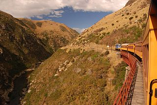
In its early years, Outram served as the railhead during the construction of the Taieri Gorge section of the Otago Central Railway (now preserved as the Taieri Gorge Railway). Trains ran six days a week as promised, and due to restrictions on the weight of locomotives allowed to cross the Taieri River bridge, the line was operated by small tank locomotives such as the F class, with the WF class being the heaviest class permitted. [1]
In 1930, two services ran return daily, but this was seen to be excessive and trains were cut to run once daily. These services were mixed trains and they operated until 13 January 1950, when the passenger component was cancelled and the line became freight only. The line was proving uneconomic and the cessation of passenger services could not save its poor financial state. By the early 1950s, traffic was almost non-existent: 107 tonnes of agricultural lime and fertiliser were railed in a week, with a meagre seven tonnes of freight railed out. Outram was very adequately served by road transportation and the railway was overdue for maintenance - it was clear it would not be beneficial to keep it open any longer. Accordingly, the line was closed to all traffic on 5 December 1953. [2]
It is typical for both nature and human activity to reduce or wholly destroy traces of closed railway lines, and little remains of the Outram Branch. In Outram itself, the goods shed has been incorporated as part of a road transportation company's depot, and outside of the town, across the Taieri River, School Road uses the old route of the railway for nearly three kilometres. Concrete abutments at the location of a long-gone bridge over a small creek are still present, as are some traces of the line's formation at points along its former route, and the site of the Dukes Road station still possesses its concrete platform. [4]

Railway preservation in New Zealand is the preservation of historically significant facets of New Zealand's rail transport history. The earliest recorded preservation attempt took place in 1925, although the movement itself did not start properly until 1960.

Rail transport in New Zealand is an integral part of New Zealand's transport network, with a nationwide network of 4,375.5 km (2,718.8 mi) of track linking most major cities in the North and South Islands, connected by inter-island rail and road ferries. Rail transport in New Zealand has a particular focus on bulk freight exports and imports, with 19 million net tonnes moved by rail annually, accounting for more than half of rail revenue.

The Taieri River is the fourth-longest river in New Zealand and is in Otago in the South Island. Rising in the Lammerlaw Range, it initially flows north, then east around the Rock and Pillar range before turning southeast, reaching the sea 30 kilometres (19 mi) south of Dunedin.
Dunedin Railways is the trading name of Dunedin Railways Limited, an operator of a railway line and tourist trains based at Dunedin Railway Station in the South Island of New Zealand. The company is a council-controlled trading organisation wholly owned by Dunedin City Council through its holding company Dunedin City Holdings Limited.
The Waikaka Branch was a branch line railway of the Main South Line that ran through agricultural and gold-mining country in Southland, New Zealand. It was constructed in 1907 and 1908, and was operated by the New Zealand Railways Department until its closure in 1962.
The Tapanui Branch was a railway line located near the border of the regions of Southland and Otago, New Zealand. Although the name suggests that it terminated in Tapanui, its furthest terminus was actually in Edievale. Construction of the line began in 1878 with the first section opened in 1880, and it operated until 1978, when it was destroyed by flooding from the Pomahaka River.

The Main South Line, sometimes referred to as part of the South Island Main Trunk Railway, is a railway line that runs north and south from Lyttelton in New Zealand through Christchurch and along the east coast of the South Island to Invercargill via Dunedin. It is one of the most important railway lines in New Zealand and was one of the first to be built, with construction commencing in the 1860s. At Christchurch, it connects with the Main North Line to Picton, the other part of the South Island Main Trunk.

The Port Chalmers Branch was the first railway line built in Otago, New Zealand, and linked the region's major city of Dunedin with the port in Port Chalmers. The line is still operational today.
The Waimate Branch was a branch line railway built in southern Canterbury, New Zealand to link the Main South Line with the town of Waimate, the centre of the surrounding rural area. It opened in 1877 and operated until 1966; for some of this time, it included an extension to Waihao Downs that was known as the Waimate Gorge Branch or Waihao Downs Branch. When the line closed, Waimate received the dubious distinction of being New Zealand's first major town to lose its railway line.

The Foxton Branch was a railway line in New Zealand. It began life as a tramway, reopened as a railway on 27 April 1876, and operated until 18 July 1959. At Himatangi there was a junction with the Sanson Tramway, a line operated by the Manawatu County Council that was never upgraded to the status of a railway.
The Kaitangata Line, also known as the Kaitangata Branch in its first years of operation, was a railway line in Otago, New Zealand. It was built by a private company and was later acquired by the government's Mines Department, and operated from 1876 until 1970. It provided a link from coal mines to the Main South Line, and was never integrated into the network managed by the New Zealand Railways Department, thus although it could be seen as a branch line of the Main South Line, it officially never was.
The Catlins River Branch was a branch line railway that formed part of New Zealand's national rail network. It ran through the Catlins region in southwestern Otago and was built in sections between 1879 and 1915. It closed in 1971 except for the first four kilometres, which remain open as the Finegand Branch. Along the line was the Hunts Road tunnel, the southernmost tunnel in New Zealand.
The Waimea Plains Railway was a secondary railway line that linked the towns of Lumsden and Gore in northern Southland, New Zealand. It skirted the Hokonui Hills, and operated as a through route between 31 July 1880 and 1 April 1971, with the short section from Lumsden to Balfour continuing as the Balfour Branch until 15 January 1978.

The Waikaia Branch, also known as the Switzers Branch, was a branch line railway in Southland, New Zealand. Proposed as early as the 1870s, it was not opened until 1909 and was operated by the New Zealand Railways Department for half a century until its closure in 1959.

The Otago Central Railway (OCR) or in later years Otago Central Branch Railway, now often referred to as the Taieri Gorge Railway, was a secondary railway line in Central Otago, in the South Island of New Zealand.
The Roxburgh Branch was a branch line railway built in the Otago region of New Zealand's South Island that formed part of the country's national rail network. Originally known as the Lawrence Branch, it was one of the longest construction projects in New Zealand railway history, beginning in the 1870s and not finished until 1928. The full line was closed in 1968.
The Dunback and Makareao Branches were two connected branch line railways, part of New Zealand's national rail network. Located in the Otago region of the South Island, both lines were 15 kilometres (9.3 mi) in length and shared the first 11 kilometres (6.8 mi). The Dunback Branch, also known as the Waihemo Branch, opened in 1885 and closed in 1968; the Makareao Branch, also known as the Inch Valley Railway or the Inch Valley Branch, opened in 1900 and operated for 89 years to 1989.

The Oxford Branch was a branch line railway that formed part of New Zealand's national rail network. It was located in the Canterbury region of the South Island, and ran roughly parallel with the Eyreton Branch that was located some ten kilometres south. It opened to Oxford in 1875 and survived until 1959.
The Ross Branch, officially known as the Hokitika Line since 2011, and previously as the Hokitika Industrial Line, is a branch line railway that forms part of New Zealand's national rail network. It is located in the Westland District of the South Island's West Coast region and opened to Hokitika in 1893. A further extension to Ross operated from 1 April 1909 until 24 November 1980.

The Seddonville Branch, later truncated as the Ngākawau Branch, is a branch line railway in the West Coast region of New Zealand's South Island. Construction began in 1874 and it reached its terminus at the Mokihinui Mine just beyond Seddonville in 1895. In 1981 it was closed past Ngākawau and effectively became an extension of the Stillwater–Westport Line, since formalised as the Stillwater–Ngākawau Line.