Allanton, New Zealand

Last updated • 3 min readFrom Wikipedia, The Free Encyclopedia

Allanton
Rural settlement
Allanton, New Zealand
Coordinates: 45°55′S170°16′E / 45.917°S 170.267°E / -45.917; 170.267
CountryNew Zealand
Island South Island
Region Otago
District Dunedin
Community board Mosgiel-Taieri Community Board [1]
Electorates
Government
   Territorial authority Dunedin City Council
  Regional council Otago Regional Council
   Mayor of Dunedin Jules Radich
   Taieri MP Ingrid Leary
   Te Tai Tonga MP Tākuta Ferris
Area
[2]
  Total0.79 km2 (0.31 sq mi)
Population
 (June 2024) [3]
  Total340
  Density430/km2 (1,100/sq mi)
Time zone UTC+12 (NZST)
  Summer (DST) UTC+13 (NZDT)
Postcode
9092
Area code03
Local iwi Ngāi Tahu

Allanton (Māori : Ōwhiro) is a small town in Otago, New Zealand, located some 20 kilometres southwest of Dunedin on State Highway 1. The settlement lies at the eastern edge of the Taieri Plains close to the Taieri River at the junction of the main road to Dunedin International Airport at Momona. [4]

Contents

Established near the junction of the Taieri River and Owhiro Stream the site was first known to Europeans as "Scroggs' Creek Landing" after Samuel Scroggs, a member of Charles Kettle's survey teams. The surrounding area was (and still is) known as Owhiro. In 1875, with the arrival of the railway south from Dunedin; and satisfying criteria for a "town", the community was renamed Greytown - after former Governor Sir George Grey. Among those who took up land in the growing community were immigrant Poles, [5] from among the "Brogdenites" who had constructed the railway. Several Polish surnames survive in the local community.

In 1895 a conflict of identity was recognised between the local community and another Greytown, well established in the Wairarapa. The Taieri County Council met and agreed to again rename the community. By a unanimous decision it was given the name "Allanton" - as a gesture of respect for the late James Allan of nearby "Hopehill", a former Otago Provincial Councillor, County Councillor and East Taieri Church Elder. [6]

Allanton's community has declined in recent years, with the local school closing in 2004 and the Sacred Heart Catholic Church closing the following year. [7] The final shop to close was the 'Honey Shoppe', which closed in 2011.[ citation needed ]

Demographics

Allanton is described by Statistics New Zealand as a rural settlement. It covers 0.79 km2 (0.31 sq mi), [2] and had an estimated population of 340 as of June 2024, [3] with a population density of 430 people per km2. It is part of the much larger Momona statistical area. [8]

Historical population
YearPop.±% p.a.
2006240    
2013255+0.87%
2018306+3.71%
Source: [9]

Allanton had a population of 306 at the 2018 New Zealand census, an increase of 51 people (20.0%) since the 2013 census, and an increase of 66 people (27.5%) since the 2006 census. There were 126 households, comprising 153 males and 150 females, giving a sex ratio of 1.02 males per female, with 54 people (17.6%) aged under 15 years, 39 (12.7%) aged 15 to 29, 162 (52.9%) aged 30 to 64, and 45 (14.7%) aged 65 or older.

Ethnicities were 95.1% European/Pākehā, 5.9% Māori, and 1.0% Pasifika. People may identify with more than one ethnicity.

Although some people chose not to answer the census's question about religious affiliation, 62.7% had no religion, 25.5% were Christian and 1.0% had other religions.

Of those at least 15 years old, 33 (13.1%) people had a bachelor's or higher degree, and 54 (21.4%) people had no formal qualifications. 42 people (16.7%) earned over $70,000 compared to 17.2% nationally. The employment status of those at least 15 was that 150 (59.5%) people were employed full-time, 30 (11.9%) were part-time, and 3 (1.2%) were unemployed. [9]

Education

The Dunedin campus of OneSchool Global is at Allanton. OneSchool Global is an international private composite school. [10]

The local state primary school was merged to East Taieri School in 2004. [11]

Related Research Articles

<span class="mw-page-title-main">Otago</span> Region of New Zealand

Otago is a region of New Zealand located in the southern half of the South Island administered by the Otago Regional Council. It has an area of approximately 32,000 square kilometres (12,000 sq mi), making it the country's second largest local government region. Its population was 257,200 in June 2024.

<span class="mw-page-title-main">Middlemarch, New Zealand</span> Human settlement in Dunedin City, Otago Region, New Zealand

Middlemarch is a small town in the Otago region of New Zealand's South Island. It lies at the foot of the Rock and Pillar Range of hills in the broad Strath-Taieri valley, through which flows the middle reaches of the Taieri River. Since local government reorganisation in the late 1980s, Middlemarch and much of the Strath-Taieri has been administered as part of Dunedin city, the centre of which lies some 80 km to the southeast. Middlemarch is part of the Taieri electorate, and is currently represented in parliament by Ingrid Leary. Middlemarch has reticulated sewerage but no reticulated water supply. A description of 1903, that "[T]he summer seasons are warm, but not enervating, and the winters cold, but dry" is still true today.

<span class="mw-page-title-main">Dunedin</span> City in Otago, New Zealand

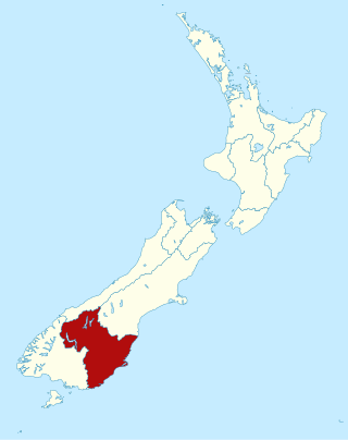
Dunedin is the second-largest city in the South Island of New Zealand, and the principal city of the Otago region. Its name comes from Dùn Èideann, the Scottish Gaelic name for Edinburgh, the capital of Scotland. The city has a rich Māori, Scottish, and Chinese heritage.

<span class="mw-page-title-main">Mosgiel</span> Town in Otago, New Zealand

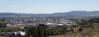
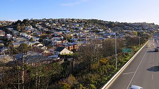
Mosgiel is an urban satellite of Dunedin in Otago, New Zealand, fifteen kilometres west of the city's centre. Since the re-organisation of New Zealand local government in 1989 it has been inside the Dunedin City Council area. Mosgiel has a population of approximately 15,150 as of June 2024. A nickname for Mosgiel is "The pearl of the plain". Its low-lying nature does pose problems, making it prone to flooding after heavy rains. Mosgiel takes its name from Mossgiel Farm, Ayrshire, the farm of the poet Robert Burns, the uncle of the co-founder in 1848 of the Otago settlement, the Reverend Thomas Burns.

<span class="mw-page-title-main">Taieri Plain</span> Plain in New Zealand

The Taieri Plain is an area of fertile agricultural land to the southwest of Dunedin, in Otago, New Zealand. The plain covers an area of some 300 square kilometres, with a maximum extent of 30 kilometres. It is not to be confused with Strath Taieri, a second plain of the Taieri River, 40kms to the north beyond Mount Ross.

South Otago lies in the south east of the South Island of New Zealand. As the name suggests, it forms the southernmost part of the geographical region of Otago.

<span class="mw-page-title-main">Brighton, New Zealand</span> Settlement in New Zealand

Brighton is a small seaside town within the city limits of Dunedin on New Zealand's South Island. It is located 20 kilometres southwest from the city centre on the Southern Scenic Route.

<span class="mw-page-title-main">Taieri Mouth</span> Rural settlement in Otago, New Zealand

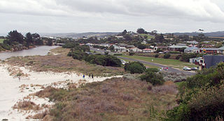
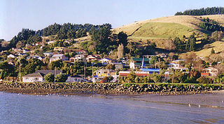
Taieri Mouth is a small fishing village at the mouth of the Taieri River, New Zealand. Taieri Island (Moturata) lies in the ocean several hundred metres off the river's mouth.

<span class="mw-page-title-main">Strath Taieri</span> Geographic region in New Zealand

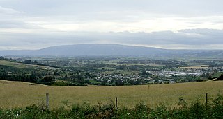
The Strath Taieri is a large glacial valley and river plateau in New Zealand's South Island. It is surrounded by the rugged hill ranges to the north and west of Otago Harbour. Since 1989 it has been part of the city of Dunedin. The small town of Middlemarch is located at its southern end.

Momona is a small town on the Taieri Plain in New Zealand's South Island. Momona School was established in 1899 and closed in 2004. The Henley Co-operative Dairy Company, established in nearby Henley, moved their cheese factory here, and was closed in the 1980s.

<span class="mw-page-title-main">Macandrew Bay</span> Suburb in Dunedin, New Zealand

Macandrew Bay is located on the Otago Peninsula in the South Island of New Zealand. It is situated on the edge of Otago Harbour, and is named for pioneer Scottish settler James Macandrew who lived here during his later life. The Te Reo Māori name for the bay, Te Roto Pāteke, refers to the Brown teal formerly prevalent in the area. Early European residents of the area called the bay "The Hundreds", due to the large number of boulders which covered the foreshore.

<span class="mw-page-title-main">Outram, New Zealand</span> Town in the South Island of New Zealand

Outram is a rural suburb of Dunedin, New Zealand, with a population of 910 as of June 2024. It is located 28 kilometres west of the central city at the edge of the Taieri Plains, close to the foot of Maungatua. The Taieri River flows close to the southeast of the town. Outram lies on State Highway 87 between Mosgiel and Middlemarch.

<span class="mw-page-title-main">Fairfield, Otago</span> Suburb in Dunedin, New Zealand

Fairfield is a suburb of Dunedin, New Zealand.

Wakari is a residential suburb of the New Zealand city of Dunedin. It is located 2.5 kilometres (1.6 mi) to the northwest of the city centre, immediately to the west of the ridge which runs to the west of the city's centre. Wakari lies to the north of the upper reaches of the Kaikorai Valley, and is also north of the suburb of Kaikorai. The suburbs of Roslyn and Maori Hill are situated on the ridge immediately to the southeast and east of Wakari. The suburb of Halfway Bush lies to the northwest, and the smaller suburb of Helensburgh lies to the north.

<span class="mw-page-title-main">Calton Hill, New Zealand</span> Suburb of Dunedin, New Zealand

Calton Hill is an elevated southern residential suburb of the City of Dunedin in New Zealand's South Island. The suburb is named after Calton Hill in Edinburgh, Scotland, and some of its street names carry similar etymological roots.

<span class="mw-page-title-main">Ravensbourne, New Zealand</span> Suburb of Dunedin, New Zealand

Ravensbourne is a suburb of the New Zealand city of Dunedin. It is located on Otago Harbour on the steep southeastern slopes of Signal Hill. It lies on the harbour's northern shore, 4.5 kilometres (2.8 mi) east-northeast of the city centre.

<span class="mw-page-title-main">Halfway Bush</span> Suburb of Dunedin, New Zealand

Halfway Bush is a suburb of the New Zealand city of Dunedin. It is located 3 kilometres (1.9 mi) to the northwest of the city centre, close to the point at which Taieri Road becomes the winding rural Three Mile Hill Road. It was this road which gave the suburb its name, as this locality was halfway between the Taieri Plains and central Dunedin in the early days of European settlement, when Three Mile Hill was the main route from Dunedin to the Otago hinterland. This route was superseded by the route through the Caversham Valley in the 1860s.

<span class="mw-page-title-main">Wingatui</span> Settlement in New Zealand

Wingatui is a small settlement almost 15 kilometres west of Dunedin, and two kilometres east of Mosgiel. It has become a suburb of Mosgiel, but continues to maintain its own unique identity and heritage.

<span class="mw-page-title-main">East Taieri</span> Settlement in New Zealand

East Taieri is a small township, located between Mosgiel and Allanton in New Zealand's Otago region. It lies on State Highway 1 en route between the city of Dunedin and its airport at Momona. It lies close to the southeastern edge of the Taieri Plain, hence its name.

<span class="mw-page-title-main">Whare Flat</span> Locality in Otago Region, New Zealand

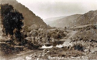
Whare Flat is a locality some 15 km to the northwest of Dunedin city centre, in the South Island of New Zealand. It is located at a widening of the Silver Stream's valley amid the foothills of the Silverpeaks.

References

  1. "2016 Mosgiel-Taieri Community Board Boundary" (PDF). dunedin.govt.nz. Dunedin City Council . Retrieved 2 June 2022.
  2. 1 2 "ArcGIS Web Application". statsnz.maps.arcgis.com. Retrieved 28 December 2021.
  3. 1 2 "Aotearoa Data Explorer". Statistics New Zealand . Retrieved 26 October 2024.
  4. Dowling, P. (ed.) (2004) Reed New Zealand atlas, Auckland: Reed Publishing (NZ). ISBN   0-7900-0952-8. Map 103.
  5. Sawicka, T. "Poles - The first arrival," Te Ara - the Encyclopedia of New Zealand, updated 13 July 2012. Retrieved 15 April 2013.
  6. Reed, A. W. (1975). Place names of New Zealand. Wellington: A. H. & A. W. Reed. ISBN   0-589-00933-8., p. 9
  7. Loughrey, David "Sad moment for Allanton congregation: Church marks final day," Otago Daily Times 12 September 2005. Retrieved 15 April 2013.
  8. 2018 Census place summary: Momona
  9. 1 2 "Statistical area 1 dataset for 2018 Census". Statistics New Zealand. March 2020. 7028264 and 7028265.
  10. "Dunedin". OneSchool Global. Retrieved 28 December 2021.
  11. Mallard, Trevor (2 August 2003). "Final decision on Taieri schools announced". New Zealand Government.