Related Research Articles

Ashburton is a large town in the Canterbury Region, on the east coast of the South Island of New Zealand. The town is the seat of the Ashburton District. It is 85 kilometres (53 mi) south west of Christchurch and is sometimes regarded as a satellite town of Christchurch.

Timaru is a port city in the southern Canterbury region of New Zealand, located 157 kilometres (98 mi) southwest of Christchurch and about 196 kilometres (122 mi) northeast of Dunedin on the eastern Pacific coast of the South Island. The Timaru urban area is home to 28,700 people, and is the largest urban area in South Canterbury, and the second largest in the Canterbury Region overall, after Christchurch. The town is the seat of the Timaru District, which includes the surrounding rural area and the towns of Geraldine, Pleasant Point and Temuka, which combined have a total population of 48,400.

Methven is a small town in the Canterbury region of the South Island of New Zealand. Methven was named by an early colonial pioneer, a Mr. R. Patton, who named it for his home in Scotland. It is located near the western edge of the Canterbury Plains, 35 kilometres north of Ashburton and 95 kilometres west of Christchurch. The town slogan is "Amazing Space".
Tinwald is a town in Canterbury, New Zealand, now little more than a suburb of Ashburton. It lies to the south of the larger town, separated from it by the Ashburton River. The town was named after Tinwald Downs in Scotland, birthplace of an early european resident and owner of much of the land, Robert Wilkin.

Heathcote Valley is a suburb of Christchurch, New Zealand. It is named after Sir William Heathcote, who was secretary of the Canterbury Association.

Mayfield is a small farming settlement in Mid Canterbury, in New Zealand's South Island. It is located 35 km from Ashburton on former State Highway 72 at the intersection of the Lismore-Mayfield Road towards the top of the Canterbury Plains. Mayfield is within the Ashburton District Council and Canterbury Regional Council boundaries. The population of the Mayfield village is around 200. The majority of the population is engaged either directly or indirectly in farming or farming related services.

St Albans is a large, inner-northern suburb of Christchurch, New Zealand, located directly north of the Christchurch Central Business District. It is the second largest suburb in the city by population, with a population of 13,137 at the 2018 Census. The suburb falls within the Christchurch Central electorate and is represented by Duncan Webb, who has been the MP since the general election of 2017. St Albans is one of the most diverse residential neighbourhoods in Christchurch, with a wide range of densities, architectural styles and housing ages throughout the suburb. It has everything from run-down high-density council-owned flats, to modern luxurious high-density flats and apartments; old mid-density workers cottages through to large low-density estates of various ages.

Wakanui is a locality in the Ashburton District, New Zealand. The area is rural and close to the sea. Historically it is known as a grain-producing area. It holds New Zealand's largest feedlot, where Wakanui Beef is produced through intensive farming.
The Mid Canterbury Rugby Football Union (MCRFU) is a rugby province in the South Island of New Zealand.

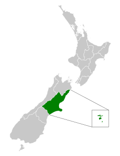
Mid Canterbury is a traditional, semi-official subregion of New Zealand's Canterbury Region extending inland from the Pacific coast to the Southern Alps. It is one of four traditional sub-regions of Canterbury, along with South Canterbury, North Canterbury, and Christchurch City.

Willowby is a lightly populated locality in the Canterbury region of New Zealand's South Island. It is situated in Mid-Canterbury, south of Ashburton, the major town of the area. Other nearby settlements include Hinds and Lynnford to the southwest, Eiffelton to the south, and Huntingdon to the east.
Huntingdon is a lightly populated locality in the Canterbury region of New Zealand's South Island. It is situated on the southern bank of the Ashburton River, south of Ashburton. Other nearby settlements include Willowby to the west, Wheatstone, Flemington, and Ashton to the south, and Wakanui to the east across the river.
Ashburton Domain is a cricket ground in Ashburton, Canterbury, New Zealand. The first recorded match on the ground came when Ashburton County played the touring Tasmania team in 1884. The ground later held its first senior match when Canterbury played Otago in the 1980/81 Shell Cup. Three further List A matches have been held on the ground, the last of which saw Canterbury play Central Districts in the 1988/89 Shell Cup.
Chertsey is a town in the Ashburton District, of New Zealand's South Island. It is located close to State Highway 1, which bypasses the town to the west, between Ashburton and Rakaia on the Canterbury Plains. According to the 2013 census 2,493 people usually live with in the Chertsey District. This is an increase of 288 people, or 13.1 percent, since the 2006 Census.
Fairton is a town in the Ashburton District, New Zealand. According to the 2001 New Zealand census it had a population of 1185, of which 612 were male and 573 were female.
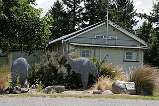
Alford Forest is a location in Canterbury, Ashburton District, New Zealand.

The South Canterbury District Health Board is a district health board with the focus on providing healthcare to the Timaru, Mackenzie, Waimate districts in New Zealand.
The Canterbury District Health Board is a district health board with the focus on providing healthcare to the Canterbury region of New Zealand north of the Rangitata River. It is responsible for roughly 510,000 residents; or 12% of New Zealand's population. The Canterbury District Health Board covers a territory of 26,881 square kilometers and is divided between six territorial local authorities.
Parkside is a suburb of Timaru, in the Timaru District and Canterbury Region of New Zealand's South Island.
Ashburton Central is the central suburb and central business district of Ashburton, in the Ashburton District and Canterbury Region of New Zealand's South Island.
References
- ↑ "Allenton RFC". allentonrfc.co.nz. Allenton Rugby Football Club.
- ↑ "Ashburton Hospital – Ministry of Health Profile". health.govt.nz. Ministry of Health.
Coordinates: 43°52′31″S171°43′02″E / 43.8753561°S 171.7170968°E
| This Canterbury Region-related geography article is a stub. You can help Wikipedia by expanding it. |