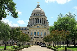
Jackson is the capital of and the most populous city in the U.S. state of Mississippi. Along with Raymond, Jackson is one of two county seats for Hinds County. The city had a population of 153,701 at the 2020 census, a significant decline from 173,514, or 11.42%, since the 2010 census, representing the largest decline in population during the decade of any major U.S. city. Jackson is the anchor for the Jackson metropolitan statistical area, the largest metropolitan area located entirely in the state and the tenth-largest urban area in the Deep South. With a 2020 population of nearly 600,000, metropolitan Jackson is home to over one-fifth of Mississippi's population. The city sits on the Pearl River and is located in the greater Jackson Prairie region of Mississippi. Jackson is the only city in Mississippi with a population exceeding 100,000 people.
Hanwell is a town in the London Borough of Ealing. It is about 1.5 miles (2.4 km) west of Ealing Broadway and had a population of 28,768 as of 2011. It is the westernmost location of the London post town.

The Catlins comprise an area in the southeastern corner of the South Island of New Zealand. The area lies between Balclutha and Invercargill, straddling the boundary between the Otago and Southland regions. It includes the South Island's southernmost point, Slope Point.

The Rangitata River is one of the braided rivers of the Canterbury Plains in southern New Zealand. It flows southeast for 120 kilometres (75 mi) from the Southern Alps, entering the Pacific Ocean 30 kilometres (19 mi) northeast of Timaru. The river has a catchment area of 1,773 square kilometres (685 sq mi), and a mean annual flow of 95 cubic metres per second (3,400 cu ft/s) at Klondyke.
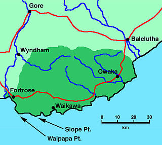
Fortrose is a locality on the southernmost coast of the South Island of New Zealand in the Southland region. It is situated on Toetoes Bay at the mouth of the Mataura River, and is on the far western edge of the Catlins. Nearby settlements include Otara to the southeast, Pukewao and Tokanui to the northeast, and Titiroa and Waimahaka to the north.

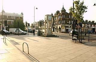
Norwood Green is a place in the London Borough of Ealing in London, England, that forms the southern part of Southall. It is a suburban development centred 10.7 miles (17.2 km) west of Charing Cross and 4 miles (6.4 km) ENE of Heathrow Airport.

Kowanyama is a town and coastal locality in the Aboriginal Shire of Kowanyama, Queensland, Australia.
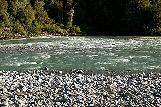
Ealing is a lightly populated rural locality on the bank of the Rangitata River in the Canterbury region of New Zealand's South Island. It has a community hall, a small combined Protestant faith church and a rural fire unit based in the centre of the town. Ealing was settled as a railway village in the 1870s whilst the Main South Line's bridge over the Rangitata River was being built. Along with the schools in nearby Lynnford and Maronan, the local school was shut due to population decline during the 1930s and students sent to the primary school in Hinds, a small nearby town to the northeast and Carew in the west. The former school building is now the church. Ealing is more a common locality than a settlement, with the area being referred to as the "Ealing district". Each year a Guy Fawkes Night fireworks display and a Christmas party in Ealing District Hall are held to foster community spirit.
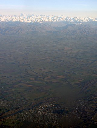
Mid Canterbury is a traditional, semi-official subregion of New Zealand's Canterbury Region extending inland from the Pacific coast to the Southern Alps. It is one of four traditional sub-regions of Canterbury, along with South Canterbury, North Canterbury, and Christchurch City.
The Hinds River is a river in the Canterbury region of New Zealand. Its north and south branches drain the eastern flank of the Moorhouse Range, part of the Southern Alps, and their confluence is near Anama and Mayfield. The river then flows across the Canterbury Plains towards the Pacific Ocean, passing through the small town of Hinds along the way. In Hinds, State Highway 1 and the Main South Line railway cross the river. The river's mouth is located between the localities of Longbeach and Lowcliffe.
Longbeach is a lowly populated locality in the Canterbury region of New Zealand's South Island. It is located in a rural area of the Canterbury Plains on the shore of the Pacific Ocean on the northern side of the Hinds River's mouth.

Eiffelton is a lightly populated locality in the Mid-Canterbury region of New Zealand's South Island.

Hinds is a small town in the Mid-Canterbury region of New Zealand's South Island. It is located on the Canterbury Plains on the south bank of the Hinds River, which reaches the Pacific Ocean between the nearby localities of Longbeach and Lowcliffe. Other localities around Hinds include Ealing to the west, Willowby, Windermere, and Winslow to the northeast, and Eiffelton to the southeast.
Lynnford is a lightly populated locality in the Mid-Canterbury region of New Zealand's South Island. It is situated between Hinds and Eiffelton on the banks of the Hinds River, which reaches the Pacific Ocean not far to the southeast, between the nearby localities of Longbeach and Lowcliffe. Other localities close to Lynnford are Willowby and Windermere to the north.
The Mōkihinui River is a river located on the West Coast of New Zealand's South Island, about 40 kilometres north of Westport. Meridian Energy had proposed the Mokihinui Hydro project on the river in 2007 but it was cancelled in May 2012. In 2019, it was announced that 64,400 ha of land in the Mōkihinui River catchment, including 15 km (9.3 mi) of river bed, would be added to Kahurangi National Park.

Hector and Ngakawau are two lightly populated settlements located at the mouth of the Ngākawau River in the West Coast region of New Zealand. Both settlements are situated on State Highway 67 between Westport and Karamea. Despite a low population, many of the workers at New Zealand's largest open-cut coal mine at Stockton choose to live at these places and shuttles frequently operate between the two places.
Willowby is a lightly populated locality in the Canterbury region of New Zealand's South Island. It is situated in Mid-Canterbury, south of Ashburton, the major town of the area. Other nearby settlements include Hinds and Lynnford to the southwest, Eiffelton to the south, and Huntingdon to the east.

The Rangitata Diversion Race or RDR is a combined irrigation and power generation scheme that diverts water from the Rangitata River to irrigate over 66,000 hectares of farmland in Mid-Canterbury, New Zealand. The RDR project was the first major river diversion in New Zealand, and the largest irrigation scheme in the country. It was originally constructed by the Public Works Department between 1937 and 1944. The main canal is 67 km long, 10 m wide and 3 m deep.

The Pipe Shed in Methven, New Zealand, is a section of pipe cast in 1940 that was converted to a shed for storing explosives. The pipe was one of approximately 800 manufactured for the Rangitata Diversion Race (RDR), and is the only one that remains visible. It serves as a memorial to what was the largest public works project of its time, and is registered as a Category I structure by Heritage New Zealand.
