
Whanganui, also spelled Wanganui, is a city in the Manawatū-Whanganui region of New Zealand. The city is located on the west coast of the North Island at the mouth of the Whanganui River, New Zealand's longest navigable waterway. Whanganui is the 19th most-populous urban area in New Zealand and the second-most-populous in Manawatū-Whanganui, with a population of 42,800 as of June 2023.

Ashburton is a large town in the Canterbury Region, on the east coast of the South Island of New Zealand. The town is the seat of the Ashburton District. It is 85 kilometres (53 mi) south west of Christchurch and is sometimes regarded as a satellite town of Christchurch.

Timaru is a port city in the southern Canterbury Region of New Zealand, located 157 km (98 mi) southwest of Christchurch and about 196 km (122 mi) northeast of Dunedin on the eastern Pacific coast of the South Island. The Timaru urban area is home to 28,900 people, and is the largest urban area in South Canterbury, and the third-largest in the Canterbury Region overall, after Christchurch and Rolleston. The town is the seat of the Timaru District, which includes the surrounding rural area and the towns of Geraldine, Pleasant Point and Temuka, which combined have a total population of 48,900.

Geraldine is a town in the Canterbury region in the South Island of New Zealand. It is about 140 km south of Christchurch, and inland from Timaru, which is 38 km to the south. Geraldine is located on State Highway 79 between the Orari and Hae Hae Te Moana Rivers and 45 kilometres to the east of Fairlie.

Dargaville is a town located in the North Island of New Zealand. It is situated on the bank of the Northern Wairoa River in the Kaipara District of the Northland region. Dargaville is located 55 kilometres (34 mi) southwest of Whangārei, and 174 kilometres (108 mi) north of Auckland.
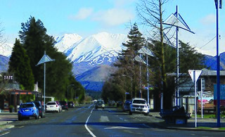
Methven is a small town in the Canterbury region of the South Island of New Zealand. It is located near the western edge of the Canterbury Plains, 35 km (22 mi) north of Ashburton and 95 km (59 mi) west of Christchurch, and at an elevation of 320 m (1,050 ft). The town is a service centre for agriculture in the surrounding area, and is a base for skiing at the nearby Mount Hutt skifield. The town slogan is "Amazing Space".

Wairoa is a town and territorial authority district in New Zealand's North Island. The town is the northernmost in the Hawke's Bay region, and is located on the northern shore of Hawke Bay at the mouth of the Wairoa River and to the west of Māhia Peninsula. It is on State Highway 2, 118 kilometres (73 mi) northeast of Napier, and 92 kilometres (57 mi) southwest of Gisborne. Wairoa is the nearest town to the Te Urewera protected area and former national park that is accessible from Wairoa via State Highway 38. It is the largest town in the district of Wairoa, and is one of three towns in New Zealand, the others being Kawerau and Ōpōtiki, where Māori outnumber other ethnicities, with 62.29% of the population identifying as Māori.
Sydenham is an inner suburb of Christchurch, New Zealand, two kilometres south of the city centre, on and around the city's main street, Colombo Street. It is a residential, retail and light industrial suburb.

Mayfield is a small farming settlement in Mid Canterbury, in New Zealand's South Island. It is located 35 km from Ashburton on former State Highway 72 at the intersection of the Lismore-Mayfield Road towards the top of the Canterbury Plains. Mayfield is within the Ashburton District Council and Canterbury Regional Council boundaries. The population of the Mayfield village is around 200. The majority of the population is engaged either directly or indirectly in farming or farming related services.
The Toi PōnekeArts Centre, is the New Zealand capital's creative production facility and support complex. It was established between 2003 and 2005, and was formally opened by Mayor Kerry Prendergast in July 2005. For twelve years previous, the city's arts centre had been based at the much smaller Oriental Bay Rotunda. The new complex, spread across two buildings and seven floors, has a focus on active creative production in all disciplines, and on the further advancement of cultural identity in New Zealand. It is located in the bustling and dynamic Upper Cuba Street neighbourhood of Wellington.

The Auckland Central Business District (CBD), or Auckland city centre, is the geographical and economic heart of the Auckland metropolitan area. It is the area in which Auckland was established in 1840, by William Hobson on land gifted by mana whenuahapū Ngāti Whātua Ōrākei. It is New Zealand's leading financial hub, and the centre of the country's economy; the GDP of the Auckland Region was NZD$139 billion in the year ending September 2023.

Ashburton County was one of the counties of New Zealand in the South Island. The council first met on 4 January 1877 in the Ashburton Road Board office. It became part of Ashburton District Council in 1989, together with Ashburton Borough Council.
Ashburton Domain is a park in the centre of Ashburton, Mid Canterbury, New Zealand. Covering 37 hectares, it includes gardens, a lake, a cricket ground and other sporting facilities.
Fairton is a town in the Ashburton District, New Zealand. According to the 2001 New Zealand census it had a population of 1185, of which 612 were male and 573 were female.
Ashburton District Council is the territorial authority for the Ashburton District of New Zealand. The council consists of the mayor of Ashburton and nine ward councillors.

The Hundertwasser Art Centre with Wairau Māori Art Gallery is an art and cultural centre in Whangārei, New Zealand. It is the conception of artist and architect Friedensreich Hundertwasser, who lived near Kawakawa for 30 years, and was first designed in 1993. The project proved controversial and was considered and rejected a number of times until it was approved by a binding referendum in June 2015. The centre opened on 20 February 2022 with the inaugural exhibition, Puhi Ariki, curated by Nigel Borell.

Opihi is a small rural district located in the Timaru District, New Zealand. It is located just north of Pleasant Point and just to the west of Temuka. Richard Pearse lived in the area and conducted his 1903 experiments in powered flight along the banks of the Ōpihi River.

The Canterbury District Health Board was a district health board with the focus on providing healthcare to the Canterbury region of New Zealand, north of the Rangitata River. It was responsible for roughly 579,000 residents, or 12% of New Zealand's population. The Canterbury District Health Board covered a territory of 26,881 square kilometers and was divided between six territorial local authorities. In July 2022, the Canterbury DHB was merged into the national health service Te Whatu Ora.
Aigantighe Art Gallery is an art gallery located in Timaru, New Zealand. It was established in 1956 and holds the South Island's third-largest public art museum collection. It also features a sculpture garden with work from New Zealand and international sculptors.
Kulimoe'anga Stone Maka, is an interdisciplinary artist of Tongan heritage who lives in Christchurch, New Zealand. In 2011, he was awarded the Emerging Pasifika Artist Award from Creative New Zealand. Maka's work has been exhibited in museums and art galleries in New Zealand, Hawai'i Australia and Tonga. In 2020 he was selected to represent New Zealand at the 22nd Biennale in Sydney.
