Ealing, New Zealand

Last updated

Ealing
Rural locality
Ealing, New Zealand
Coordinates: 44°03′S171°25′E / 44.050°S 171.417°E / -44.050; 171.417
Country New Zealand
Region Canterbury
Territorial authority Ashburton District
WardEastern
Electorates
Government
  Territorial authority Ashburton District Council
  Regional council Environment Canterbury
   Mayor of Ashburton Neil Brown
   Rangitata MP James Meager
   Te Tai Tonga MP Tākuta Ferris

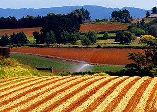
Ealing is a lightly populated rural locality on the bank of the Rangitata River in the Canterbury region of New Zealand's South Island. [1] It has a community hall, a small combined Protestant faith church and a rural fire unit based in the centre of the town. Ealing was settled as a railway village in the 1870s whilst the Main South Line's bridge over the Rangitata River was being built. Along with the schools in nearby Lynnford and Maronan, the local school was shut due to population decline during the 1930s and students sent to the primary school in Hinds, a small nearby town to the northeast and Carew in the west. [2] The former school building is now the church. Ealing is more a common locality than a settlement, with the area being referred to as the "Ealing district". Each year a Guy Fawkes Night fireworks display and a Christmas party in Ealing District Hall are held to foster community spirit.

Demographics

Ealing is in the Ealing-Lowcliffe statistical area, which also includes Hinds, and covers 413.19 km2 (159.53 sq mi) [3] and had an estimated population of 1,810 as of June 2023, [4] with a population density of 4.381 people per km2.

Historical population
YearPop.±% p.a.
20061,197    
20131,395+2.21%
20181,551+2.14%
Source: [5]

Ealing-Lowcliffe had a population of 1,551 at the 2018 New Zealand census, an increase of 156 people (11.2%) since the 2013 census, and an increase of 354 people (29.6%) since the 2006 census. There were 558 households, comprising 837 males and 714 females, giving a sex ratio of 1.17 males per female. The median age was 30.4 years (compared with 37.4 years nationally), with 405 people (26.1%) aged under 15 years, 360 (23.2%) aged 15 to 29, 705 (45.5%) aged 30 to 64, and 84 (5.4%) aged 65 or older.

Ethnicities were 74.9% European/Pākehā, 7.9% Māori, 2.1% Pasifika, 16.8% Asian, and 5.8% other ethnicities. People may identify with more than one ethnicity.

The percentage of people born overseas was 28.6, compared with 27.1% nationally.

Although some people chose not to answer the census's question about religious affiliation, 45.5% had no religion, 42.7% were Christian, 1.7% were Hindu, 0.2% were Muslim, 1.0% were Buddhist and 2.1% had other religions.

Of those at least 15 years old, 207 (18.1%) people had a bachelor's or higher degree, and 189 (16.5%) people had no formal qualifications. The median income was $42,400, compared with $31,800 nationally. 174 people (15.2%) earned over $70,000 compared to 17.2% nationally. The employment status of those at least 15 was that 720 (62.8%) people were employed full-time, 183 (16.0%) were part-time, and 30 (2.6%) were unemployed. [5]

Related Research Articles

<span class="mw-page-title-main">Puni, New Zealand</span> Place in Auckland Region, New Zealand

Puni is a rural locality in the Franklin ward of Auckland in the North Island of New Zealand. It is predominantly a dairy farming and market gardening area. The main type of crops grown are potatoes, carrots, and onions.

<span class="mw-page-title-main">Rapaura</span> Locality in Marlborough, New Zealand

Rapaura is a locality northwest of Blenheim, New Zealand. The Wairau River flows past to the north. Spring Creek lies to the east.

<span class="mw-page-title-main">Ōhura</span> Settlement in Manawatū-Whanganui Region, New Zealand

Ōhura is a small town in the west of the North Island of New Zealand. It is located to the west of Taumarunui in the area known as the King Country, in inland Manawatū-Whanganui. It lies on the banks of the Mangaroa Stream, a tributary of the Ōhura River which is a tributary of the Whanganui River.

<span class="mw-page-title-main">Eiffelton</span> Rural locality in Canterbury, New Zealand

Eiffelton is a lightly populated locality in the Mid-Canterbury region of New Zealand's South Island.

<span class="mw-page-title-main">Hinds, New Zealand</span> Town in Canterbury, New Zealand

Hinds is a small town in the Mid-Canterbury region of New Zealand's South Island. It is located on the Canterbury Plains on the south bank of the Hinds River, which reaches the Pacific Ocean between the nearby localities of Longbeach and Lowcliffe. Other localities around Hinds include Ealing to the west, Willowby, Windermere, and Winslow to the northeast, and Eiffelton to the southeast.

Lowcliffe is a lightly populated locality in the mid-Canterbury region of New Zealand's South Island. It is situated on the shore of the Pacific Ocean between the mouths of the Hinds and Rangitata Rivers. Nearby settlements include Coldstream to the west by the Rangitata River, Longbeach to the east on the other side of the Hinds River's mouth, and Hinds to the north. The closest towns of significant size are Ashburton to the northeast and Geraldine to the west.

Orari is a small town in the South Canterbury region of New Zealand's South Island, roughly midway between Ashburton to the north, and Timaru to the south it is the northernmost town of South Canterbury.

Oruaiti is a locality in Northland, New Zealand. It lies on state highway 10. Mangonui lies to the west, and Whangaroa Harbour to the east.

Pamapuria is a locality in Northland, New Zealand. It lies on State Highway 1 about 10 km east of Kaitaia.

Maromaku is a locality in the Northland Region of the North Island of New Zealand. Kawakawa is north, and Towai is southeast. State Highway 1 runs past Maromaku to the north, and the North Auckland Line runs through it.

<span class="mw-page-title-main">Waitoki</span> Place in Auckland Region, New Zealand

Waitoki is a locality in the Rodney District of New Zealand. Wainui is approximately 5.5 kilometres to the north-east, Kaukapakapa 6.5 km to the north-west, and Dairy Flat 10 km to the south-east. The Wainui Stream joins the Waitoki Stream just to the north-east of the locality. The stream flows west into the Kaukapakapa River.

<span class="mw-page-title-main">Arundel, New Zealand</span> Rural village in Canterbury, New Zealand

Arundel is a small rural village about 15 kilometres (9 mi) north of Geraldine, in the Canterbury region in the South Island of New Zealand. It is near the south bank of the Rangitata River, 3 kilometres (2 mi) from Peel Forest, an extensive podocarp forest with abundant birdlife. Arundel is flat and fertile, with fields and many mature trees.

<span class="mw-page-title-main">Ashley, New Zealand</span> Settlement in Canterbury, New Zealand

Ashley is a small town in North Canterbury, in the South Island of New Zealand. It used to have a railway station on the Main North Line that runs through the village.

Ladbrooks is a locality in Canterbury, New Zealand. It is named after William and Eliza Ladbrook, who moved to the area in 1842 on the boat the Birman.

<span class="mw-page-title-main">Rangitata (hamlet)</span> New Zealand locality

Rangitata is a settlement in New Zealand. It is located at the junction of State Highway 1 and State Highway 79. The Rangitata River is located 3 kilometres north of the town and 10.7 kilometres north of Orari.

<span class="mw-page-title-main">Te Rahu</span> Settlement in Waikato, New Zealand

Te Rahu is a rural locality in the Waipa District and Waikato region of New Zealand's North Island.

Fencourt is a rural locality in the Waipa District and Waikato region of New Zealand's North Island.

<span class="mw-page-title-main">Pukerimu</span> Locality in Waikato, New Zealand

Pukerimu is a rural locality southwest of Cambridge in the Waipa District and Waikato region of New Zealand's North Island.

Honikiwi is a locality in the Ōtorohanga District and Waikato region of New Zealand. It is northwest of Ōtorohanga.

West Plains is a locality in the Southland Region of New Zealand, northwest of Invercargill and north of Otatara. Ōreti River and its tributary Makarewa River flow through the plains. It is part of the Southland Plains.

References

  1. "Place name detail: Ealing". New Zealand Gazetteer. New Zealand Geographic Board . Retrieved 21 March 2007.
  2. Hinds School - About the School Archived 7 April 2007 at the Wayback Machine , accessed 21 March 2007
  3. "ArcGIS Web Application". statsnz.maps.arcgis.com. Retrieved 24 November 2023.
  4. "Population estimate tables - NZ.Stat". Statistics New Zealand . Retrieved 25 October 2023.
  5. 1 2 "Statistical area 1 dataset for 2018 Census". Statistics New Zealand. March 2020. Ealing-Lowcliffe (337000). 2018 Census place summary: Ealing-Lowcliffe