Wakanui

Last updated

Wakanui
Rural locality
Wakanui
Coordinates: 43°58′23″S171°49′26″E / 43.97306°S 171.82389°E / -43.97306; 171.82389
Country New Zealand
Region Canterbury
Territorial authority Ashburton District
WardEastern
Electorates
Government
  Territorial authority Ashburton District Council
  Regional council Environment Canterbury
   Mayor of Ashburton Neil Brown
   Rangitata MP James Meager
   Te Tai Tonga MP Tākuta Ferris
Wakanui flour mill in circa 1900 Wakanui flour mill.jpg
Wakanui flour mill in circa 1900

Wakanui is a locality in the Ashburton District, New Zealand. The area is rural and close to the sea. Historically it is known as a grain-producing area. It holds New Zealand's largest feedlot, where Wakanui Beef is produced through intensive farming.

Contents

History

The European history of the area started with runs 139, 140, and 150 being taken up in 1854 and 1855. Wakanui is located between Ashburton and the sea, and east of the Ashburton River / Hakatere. An early owner (probably not the initial owners) was the Kermode and Moore partnership, with George Henry Moore as manager. [1] [2]

When Kermode and Moore sold their holdings, the land was subdivided (this process finished by 1877) and more people moved into the area. Around that time, an extensive irrigation system was implemented, which was extended across all of Ashburton County, and that opened the dry but fertile land for wheat growing. Some 3,000 miles (4,800 km) of irrigation races were built throughout the county. [3]

An electoral redistribution was carried out just prior to the 1881 election and the Wakanui electorate was formed (by splitting off areas from the Coleridge and Selwyn electorates). The Wakanui electorate was in existence for two electoral cycles and was dis-established in 1887. [4]

In 1879, a large flour mill was erected in Wakanui. The five-storey building was a landmark for the rural location. In 1906, the mill building was hauled over 6 miles (9.7 km) to Ashburton. It was deemed advisable that none of the machinery be removed and in all the building weighed an estimated 260 metric tons (260 long tons; 290 short tons). The building survived the relocation without damage. [5] [6]

Wakanui School

Wakanui School opened in 1876 with an initial roll of 35 pupils. In the early decades, the roll peaked in 1890 but at the fiftieth jubilee, the roll was back where it started as more schools had opened throughout the county. [3] A full primary school (i.e. serving years 1 to 8), [7] it had 106 students as of February 2024. [8]

Wakanui Beef

ANZCO Foods feedlot in Wakanui

These days, the name Wakanui is known best for New Zealand's largest feedlot. [9] Owned by ANZCO Foods, beef is produced here; the meat is sold under the brand name Wakanui Beef. [10] The feedlot is consented for 19,000 cattle and it held 14,000 in 2018. [11] While the feedlot has been in operation since 1991, it only became widely known when animal rights group SAFE published drone footage of it in 2018 and called for feedlots to be banned. [12] [13] Damien O'Connor, as Minister of Agriculture, weighed in on the debate in support of the feedlot. He called it "innovative" and said it was, in general, "very well managed"; he added, "the image of pastoral farming is the one New Zealand promotes and it is the mainstay of our industry". [13] [14]

Demographics

The Winchmore-Wakanui statistical area surrounds Ashburton to the north, east and south, and covers 310.37 km2 (119.83 sq mi) [15] and had an estimated population of 1,640 as of June 2023, [16] with a population density of 5.3 people per km2.

Historical population
YearPop.±% p.a.
20061,284    
20131,422+1.47%
20181,536+1.55%
Source: [17]

Before the 2023 census, Winchmore-Wakanui had a larger boundary, covering 312.07 km2 (120.49 sq mi). [15] Using that boundary, Winchmore-Wakanui had a population of 1,536 at the 2018 New Zealand census, an increase of 114 people (8.0%) since the 2013 census, and an increase of 252 people (19.6%) since the 2006 census. There were 579 households, comprising 828 males and 711 females, giving a sex ratio of 1.16 males per female. The median age was 40.9 years (compared with 37.4 years nationally), with 315 people (20.5%) aged under 15 years, 237 (15.4%) aged 15 to 29, 729 (47.5%) aged 30 to 64, and 258 (16.8%) aged 65 or older.

Ethnicities were 86.9% European/Pākehā, 4.5% Māori, 1.4% Pasifika, 8.6% Asian, and 2.9% other ethnicities. People may identify with more than one ethnicity.

The percentage of people born overseas was 21.1, compared with 27.1% nationally.

Although some people chose not to answer the census's question about religious affiliation, 39.1% had no religion, 51.4% were Christian, 0.2% had Māori religious beliefs, 0.8% were Hindu, 0.2% were Muslim and 0.6% had other religions.

Of those at least 15 years old, 189 (15.5%) people had a bachelor's or higher degree, and 249 (20.4%) people had no formal qualifications. The median income was $41,400, compared with $31,800 nationally. 258 people (21.1%) earned over $70,000 compared to 17.2% nationally. The employment status of those at least 15 was that 699 (57.2%) people were employed full-time, 216 (17.7%) were part-time, and 21 (1.7%) were unemployed. [17]

Related Research Articles

<span class="mw-page-title-main">Marlborough District</span> District and unitary authority of New Zealand

Marlborough District or the Marlborough Region, commonly known simply as Marlborough, is one of the 16 regions of New Zealand, located on the northeast of the South Island. Marlborough is a unitary authority, both a district and a region. Marlborough District Council is based at Blenheim, the largest town. The unitary region has a population of 52,200.

<span class="mw-page-title-main">Ashburton, New Zealand</span> Town in Canterbury, New Zealand

Ashburton is a large town in the Canterbury Region, on the east coast of the South Island of New Zealand. The town is the seat of the Ashburton District. It is 85 kilometres (53 mi) south west of Christchurch and is sometimes regarded as a satellite town of Christchurch.

<span class="mw-page-title-main">Geraldine, New Zealand</span> Town in Canterbury, New Zealand

Geraldine is a town in the Canterbury region in the South Island of New Zealand. It is about 140 km south of Christchurch, and inland from Timaru, which is 38 km to the south. Geraldine is located on State Highway 79 between the Orari and Hae Hae Te Moana Rivers and 45 kilometres to the east of Fairlie.

<span class="mw-page-title-main">National Park, New Zealand</span> Settlement in Manawatū-Whanganui Region, New Zealand

National Park is a small town on the North Island Central Plateau in New Zealand. Also known as National Park Village, it is the highest urban township in New Zealand, at 825 metres. The village has great views of Mount Tongariro, Mount Ngauruhoe, and Mount Ruapehu.

<span class="mw-page-title-main">Bulls, New Zealand</span> Town in Manawatū-Whanganui, New Zealand

Bulls is a town in the Rangitikei District of New Zealand. It is in a fertile farming area at the junction of State Highways 1 and 3, 28 km (17 mi) northwest of Palmerston North. According to a June 2023 Statistics New Zealand estimate, Bulls has a population of 2,210 inhabitants.

<span class="mw-page-title-main">Methven, New Zealand</span> Town in Canterbury, New Zealand

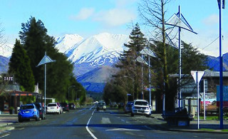
Methven is a small town in the Canterbury region of the South Island of New Zealand. It is located near the western edge of the Canterbury Plains, 35 km (22 mi) north of Ashburton and 95 km (59 mi) west of Christchurch, and at an elevation of 320 m (1,050 ft). The town is a service centre for agriculture in the surrounding area, and is a base for skiing at the nearby Mount Hutt skifield. The town slogan is "Amazing Space".

Tinwald is a town in Canterbury, New Zealand, located approximately 3 kilometres south of Ashburton, from which it is separated by the Ashburton River / Hakatere. The town was named after Tinwald Downs in Scotland, birthplace of an early European resident and owner of much of the land, Robert Wilkin.

<span class="mw-page-title-main">Mount Somers</span> Rural settlement in Canterbury, New Zealand

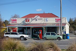
Mount Somers is a small town in Canterbury, New Zealand, nestled in the foothills of the Southern Alps. The population in the 2021 census was 160. Due to its scenic location, it has seen growth in the number of holiday homes.

Ashburton Forks, formerly known as Spreadeagle, is a defined locality on the Canterbury Plains between the forks of the Ashburton / Hakatere Rivers and within the Ashburton District of the Canterbury Province of New Zealand's South Island. It is approximately 50 km west of Ashburton and about 17 km from the foot of the Southern Alps.

<span class="mw-page-title-main">Eiffelton</span> Rural locality in Canterbury, New Zealand

Eiffelton is a lightly populated locality in the Mid-Canterbury region of New Zealand's South Island.

<span class="mw-page-title-main">Joseph Ivess</span> New Zealand politician

Joseph Ivess was a member of the New Zealand House of Representatives. He had an association with a large number of newspapers.

Wakanui was a rural parliamentary electorate in the south Canterbury region of New Zealand, from 1881 to 1887.

<span class="mw-page-title-main">Ashburton District</span> Territorial authority district in Canterbury, New Zealand

Ashburton District is a territorial authority district in the Canterbury Region of the South Island of New Zealand. It encompasses the town of Ashburton, a number of small towns and settlements and the surrounding rural area, roughly coterminous with Mid Canterbury. The district had a population of 36,800 as of June 2023.

<span class="mw-page-title-main">Tahuna, Waikato</span> Locality in Waikato, New Zealand

Tahuna is a small rural settlement located 18 km north of Morrinsville. In the Māori language Tahuna means sandbank, likely to refer to the sandbanks along the nearby Piako River, where a Māori settlement started. Tahuna is seen as the upper limit for navigatable travel on the Piako River. The settlement has a rugby club, a lawn bowls club, a golf course and various shops.

<span class="mw-page-title-main">Lake Clearwater (village)</span> Village in Canterbury, New Zealand

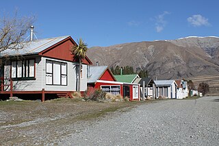
Lake Clearwater is a village in the Ashburton District of New Zealand next to a lake of the same name. A basic camp ground is located between the village and the lake.

<span class="mw-page-title-main">Koitiata</span> Settlement in Manawatū-Whanganui Region, New Zealand

Koitiata is a settlement located in the southwestern part of Rangitikei District of the Manawatū-Whanganui region of New Zealand's North Island. At the time of the 2018 census, Koitiata had a population of 126. Marton is located 24 km to the east and Whanganui is located 29 km to the northwest. Nearby Koitiata is Lake Koitiata.

<span class="mw-page-title-main">ANZCO Foods</span> New Zealand meat producer

ANZCO Foods or simply ANZCO is a New Zealand meat producer fully owned by the Japanese company Itoham Foods, which in turn is part of Itoham Yonekyu Holdings. In 2016, ANZCO Foods was New Zealand's fifth-largest exporter, with a turnover of NZ$1.5b, and 3,000 employees.

<span class="mw-page-title-main">Graeme Harrison</span> New Zealand business executive

Sir Graeme Thomas Harrison is a New Zealand business executive. He was the driving force behind ANZCO Foods, which is New Zealand's fifth-largest exporter. He was at the helm of ANZCO Foods for 34 years until his retirement in 2018.

<span class="mw-page-title-main">Allenton, New Zealand</span> Suburb in Ashburton, New Zealand

Allenton is a suburb of Ashburton, in the Ashburton District and Canterbury Region of New Zealand's South Island.

<span class="mw-page-title-main">Ashburton Central</span> Suburb in Ashburton, New Zealand

Ashburton Central is the central suburb and central business district of Ashburton, in the Ashburton District and Canterbury Region of New Zealand's South Island.

References

  1. Gardner, Jim. "Moore, George Henry". Dictionary of New Zealand Biography . Ministry for Culture and Heritage . Retrieved 18 May 2020.
  2. Acland, Leopold George Dyke (1946). The Early Canterbury Runs: Containing the First, Second and Third (new) Series. Christchurch: Whitcombe and Tombs Limited. pp. 149–154. Retrieved 18 May 2020.
  3. 1 2 "Wakanui: School jubilee, 1876–1926". The Press . Vol. XLII, no. 18805. 24 September 1926. Retrieved 18 May 2020.
  4. McRobie, Alan (1989). Electoral Atlas of New Zealand. Wellington: GP Books. pp. 45–53. ISBN   0-477-01384-8.
  5. Berry, Mark (3 May 2020). "Wakanui, New Zealand". Windmill World. Retrieved 18 May 2020.
  6. "Simple tool for big task". Ashburton Guardian. 27 May 2014. Retrieved 18 May 2020.
  7. Education Counts: Wakanui School
  8. "New Zealand Schools Directory". New Zealand Ministry of Education. Retrieved 14 March 2024.
  9. Peden, Robert (24 November 2008). "Five Star feed lot". Te Ara: The Encyclopedia of New Zealand . Retrieved 23 May 2020.
  10. Hallinan, Lynda (26 August 2018). "Grainwashing: The inconvenient truth of Wakanui beef". Sunday Star-Times . Retrieved 18 May 2020.
  11. Campbell, John (23 August 2018). "NZ's largest feedlot: 'We take great care of our animals'". Checkpoint . Retrieved 20 May 2020.
  12. Fleming, Zac (20 August 2018). "SAFE calls for end to feedlots". Radio New Zealand . Retrieved 18 May 2020.
  13. 1 2 Rowe, Don (23 August 2018). "Why you should give a damn about feedlots". The Spinoff . Retrieved 18 May 2020.
  14. "Federated Farmers hits back at 'vegan fundamentalists' SAFE". Radio New Zealand . 21 August 2018. Retrieved 13 July 2020.
  15. 1 2 "ArcGIS Web Application". statsnz.maps.arcgis.com. Retrieved 2 November 2021.
  16. "Population estimate tables - NZ.Stat". Statistics New Zealand . Retrieved 25 October 2023.
  17. 1 2 "Statistical area 1 dataset for 2018 Census". Statistics New Zealand. March 2020. Winchmore-Wakanui (337300). 2018 Census place summary: Winchmore-Wakanui