
Ashburton is a large town in the Canterbury Region, on the east coast of the South Island of New Zealand. The town is the seat of the Ashburton District. It is 85 kilometres (53 mi) south west of Christchurch and is sometimes regarded as a satellite town of Christchurch.
Anama is a sparsely populated locality in the Canterbury region of New Zealand's South Island. It is on the Hinds River, with the Ashburton River / Hakatere not far to the north in nearby Mount Somers. Other nearby settlements include Valetta to the east, Mayfield to the south, and Montalto to the west. Anama School celebrated its centenary in March 2002.
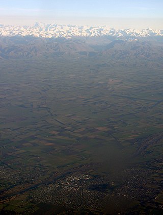
Mid Canterbury is a traditional, semi-official subregion of New Zealand's Canterbury Region extending inland from the Pacific coast to the Southern Alps. It is one of four traditional sub-regions of Canterbury, along with South Canterbury, North Canterbury, and Christchurch City.

Lake Hood is a man-made recreational lake, located 6 km south-east of Tinwald in the locality of Huntingdon, Canterbury, New Zealand. It was opened in 2001 by the Right Honourable Jenny Shipley. It is 2.3 km long by 1 km wide and is more than 80 hectares (0.80 km2) in area. It features an eight lane rowing course and separate waterskiing and jet skiing areas, and is home to Water Ski Lake Hood. It is increasing in popularity for rowing, as it is not as susceptible to wind as the main South Island rowing venue, Lake Ruataniwha.
Valetta is a lightly populated locality in the mid-Canterbury region of New Zealand's South Island. It is located in an agricultural area on the southern side of the Ashburton River / Hakatere. Another river, the Hinds River, is to Valetta's southwest. Nearby settlements include Mount Somers to the northwest, Anama to the west, Mayfield to the southwest, and Punawai to the southeast. Its name is a misspelling of Valletta, the capital of Malta.
The Hinds River is a river in the Canterbury region of New Zealand. Its north and south branches drain the eastern flank of the Moorhouse Range, part of the Southern Alps, and their confluence is near Anama and Mayfield. The river then flows across the Canterbury Plains towards the Pacific Ocean, passing through the small town of Hinds along the way. In Hinds, State Highway 1 and the Main South Line railway cross the river. The river's mouth is located between the localities of Longbeach and Lowcliffe.
Longbeach is a lowly populated locality in the Canterbury region of New Zealand's South Island. It is located in a rural area of the Canterbury Plains on the shore of the Pacific Ocean on the northern side of the Hinds River's mouth.

Eiffelton is a lightly populated locality in the Mid-Canterbury region of New Zealand's South Island.
Willowby is a lightly populated locality in the Canterbury region of New Zealand's South Island. It is situated in Mid-Canterbury, south of Ashburton, the major town of the area. Other nearby settlements include Hinds and Lynnford to the southwest, Eiffelton to the south, and Huntingdon to the east.
Huntingdon is a lightly populated locality in the Canterbury region of New Zealand's South Island. It is situated on the southern bank of the Ashburton River / Hakatere, south of Ashburton. Other nearby settlements include Willowby to the west, Wheatstone, Flemington, and Ashton to the south, and Wakanui to the east across the river.
Wheatstone is a locality in the Canterbury region of New Zealand's South Island. It is located on the Canterbury Plains south of Ashburton, on the banks of the Ashburton River / Hakatere. Other nearby settlements include Huntingdon to the north, Eiffelton and Flemington to the west, Ashton and Waterton to the south, and Riverside and Wakanui to the east on the opposite side of the Ashburton River / Hakatere. Wheatstone is slightly inland from the coastline of the Pacific Ocean.
Waterton is a former town in the Canterbury region of New Zealand's South Island. It is still officially recognised as a locality.
Flemington is a lightly populated locality in the Canterbury region of New Zealand's South Island.
The Stour River is a river of the Canterbury region of New Zealand's South Island. It rises in two main branches, the East Branch and West Branch, to the southeast of Lake Heron, flowing generally south to meet the south branch of the Ashburton River / Hakatere 15 kilometres (9 mi) west of the settlement of Mount Somers.

The Swift River is a river of the Canterbury region of New Zealand's South Island. It flows south through a valley between the Black Hill and Mount Hutt Ranges to reach the north branch of the Ashburton River / Hakatere 25 kilometres (16 mi) northwest of Methven.

Ashburton District is a territorial authority district in the Canterbury Region of the South Island of New Zealand. It encompasses the town of Ashburton, a number of small towns and settlements and the surrounding rural area, roughly coterminous with Mid Canterbury. The district had a population of 36,800 as of June 2023.
The Ashburton River / Hakatere is a river in the Canterbury region of New Zealand, flowing across Mid Canterbury from the Southern Alps to the Pacific Ocean. The official name of the river was amended to become a dual name by the Ngāi Tahu Claims Settlement Act 1998. It has been identified as an Important Bird Area by BirdLife International because it supports breeding colonies of the endangered black-billed gull.

Lake Clearwater is in the Ashburton District of the South Island of New Zealand. The outlet feeds into the south branch of the Ashburton River / Hakatere. Located in the upper reaches of the Rangitata River a small village of holiday homes, also called Lake Clearwater, is located between Lake Clearwater and the smaller neighbour Lake Camp.

Hakatere Conservation Park is a protected area between the Rakaia River and the Rangitata River in the Ashburton District of New Zealand. The park was established in 2007. It covers 60,000 hectares of rugged mountains and mountain basins, tussocklands and beech forest. It includes the Ashburton Lakes, such as Lake Heron and Lake Clearwater, popular tramping area Mount Somers / Te Kiekie, and Mount Hutt skifield. The closest town is Mount Somers.
