
Southbridge is a small town on the Canterbury Plains in the South Island of New Zealand. It is located 45 kilometres (28 mi) southwest of Christchurch, between Leeston, Dunsandel and the Rakaia River.

Eiffelton is a lightly populated locality in the Mid-Canterbury region of New Zealand's South Island.

Lewis Tilleard Natusch, but always known as Charles Natusch, was a noted New Zealand architect and quantity surveyor, known particularly as a builder of fine houses for wealthy clients.
Willowby is a lightly populated locality in the Canterbury region of New Zealand's South Island. It is situated in Mid-Canterbury, south of Ashburton, the major town of the area. Other nearby settlements include Hinds and Lynnford to the southwest, Eiffelton to the south, and Huntingdon to the east.
Wheatstone is a locality in the Canterbury region of New Zealand's South Island. It is located on the Canterbury Plains south of Ashburton, on the banks of the Ashburton River / Hakatere. Other nearby settlements include Huntingdon to the north, Eiffelton and Flemington to the west, Ashton and Waterton to the south, and Riverside and Wakanui to the east on the opposite side of the Ashburton River / Hakatere. Wheatstone is slightly inland from the coastline of the Pacific Ocean.
Ashton is a lightly populated locality in the Canterbury region of New Zealand's South Island. It is situated on the Canterbury Plains south of Ashburton, on the Pacific Ocean coastline. It is on the southern side of the Ashburton River / Hakatere's mouth. Nearby settlements include Huntingdon and Wheatstone to the north, Waterton to the southwest, and across the Ashburton River / Hakatere, Riverside to the northeast.
Waterton is a former town in the Canterbury region of New Zealand's South Island. It is still officially recognised as a locality.
Flemington is a lightly populated locality in the Canterbury region of New Zealand's South Island.
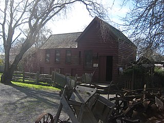
Cobblestones is a regional museum and heritage village in Greytown, New Zealand. The museum is centred around the original historic Hastwell stables and existing cobblestones used by stage coaches travelling between Masterton and Wellington. The museum contains six Category 2 Heritage NZ listed buildings, these include:

Eichardt‘s Private Hotel is located on the corner of Marine Parade and Ballarat Street, Queenstown, New Zealand, on the shores of Lake Wakatipu. Eichardt’s is a significant local landmark, and is listed as a Category Two historic place by the Historic Places Trust.

Mona Vale, with its homestead formerly known as Karewa, is a public park of 4 ha in the Christchurch, New Zealand, in the suburb of Fendalton. The homestead and gate house are both listed as heritage buildings with Heritage New Zealand (NZHPT). The fernery and the rose garden, and pavilion with the setting of the park along the Avon River, add to the attractiveness of the property. It is one of the major tourist attractions of Christchurch.

Cecil Walter Wood was a New Zealand architect. He was the dominant architect in Canterbury during the interwar period.
George Henry Moore, derogatorily known as Scabby Moore, was a New Zealand runholder and proprietor of the Glenmark estate.
Staveley is a small township in the Ashburton District, Canterbury, New Zealand.

The Thames railway station is a former railway station in Thames, New Zealand on the former Thames Branch from Morrinsville to Thames.

Moawhango is a rural community in the northern part of Rangitikei District of the Manawatū-Whanganui region of New Zealand's North Island. It is situated 19 km north of Taihape and 91 km northeast of Marton. Nearby Moawhango are located Moawhango River and Lake Moawhango.

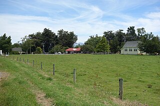
Homebush is a settlement in the Canterbury region of New Zealand. It has had a long association with the pioneering Deans family.
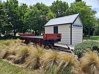
The Whitecliffs Branch historical site is an historical site containing the original, restored Homebush station building and a NZR type M wagon. The site was dedicated to the Whitecliffs Branch to commemorate the 50th anniversary of the line closing. It was officially opened on 6 February 2015 by Don Chambers at Westview Park, Darfield, New Zealand, near to the site of the junction.

The Pipe Shed in Methven, New Zealand, is a section of pipe cast in 1940 that was converted to a shed for storing explosives. The pipe was one of approximately 800 manufactured for the Rangitata Diversion Race (RDR), and is the only one that remains visible. It serves as a memorial to what was the largest public works project of its time, and is registered as a Category I structure by Heritage New Zealand.
Chilwell and Trevithick was an architectural partnership formed in Auckland, New Zealand in 1914.
