
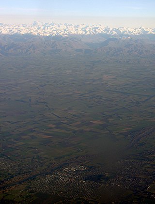
The Canterbury Plains are an area in New Zealand centred in the Mid Canterbury, to the south of the city of Christchurch in the Canterbury region. Their northern extremes are at the foot of the Hundalee Hills in the Hurunui District, and in the south they merge into the plains of North Otago beyond the Waitaki River. The smaller Amuri Plain forms a northern extension of the plains.

The Rangitata River is one of the braided rivers of the Canterbury Plains in southern New Zealand. It flows southeast for 120 kilometres (75 mi) from the Southern Alps, entering the Pacific Ocean 30 kilometres (19 mi) northeast of Timaru. The river has a catchment area of 1,773 square kilometres (685 sq mi), and a mean annual flow of 95 cubic metres per second (3,400 cu ft/s) at Klondyke.
Rangitata Island was a long lens-shaped island in the delta of the braided Rangitata River in Canterbury, New Zealand, approximately halfway between Timaru and Ashburton, New Zealand. The island was approximately 17 kilometres (11 mi) long and about 5 kilometres (3 mi) wide at its widest. Low lying, the area is mostly fertile farmland.

South Canterbury is the area of the Canterbury Region of the South Island of New Zealand bounded by the Rangitata River in the north and the Waitaki River to the south. The Pacific Ocean and ridge of the Southern Alps form natural boundaries to the east and west respectively. Though the exact boundaries of the region have never been formalised, the term is used for a variety of government agencies and other entities. It is one of four traditional sub-regions of Canterbury, along with Mid Canterbury, North Canterbury, and Christchurch city.
Mid Canterbury is a traditional, semi-official subregion of New Zealand's Canterbury Region extending inland from the Pacific coast to the Southern Alps. It is one of four traditional sub-regions of Canterbury, along with South Canterbury, North Canterbury, and Christchurch City.

The Clyde River is a river of New Zealand, one of Canterbury's braided rivers. It is formed from the confluence of the Frances River and McCoy Stream, flowing southwest to join with the Havelock River and Lawrence River to form the Rangitata River.
The Forbes River is a river in the Canterbury region of New Zealand. It arises in the Two Thumb Range and flows east into the Havelock River which joins the Rangitata River, which flows into the Pacific Ocean. The river was named by Julius von Haast after James David Forbes, Professor of Natural Philosophy at the University of Edinburgh in the mid 19th century.

The Frances River is a river of New Zealand. It arises near Lambert Col and flows south to join McCoy Stream to form the Clyde River. The Clyde flows into the Rangitata River, which eventually exits into the Pacific Ocean.
The Havelock River is a river of New Zealand. The river source is in the Cloudy Peak Range, part of the Southern Alps, between Sceptre Peak and Outram Peak. It joins the Rangitata River which flows into the Canterbury Bight between Ashburton and Temuka.
The North Barlow River is a river in the West Coast Region of New Zealand's South Island. It is one of the headwaters of the Barlow River.

The Potts River is a river of the Canterbury region of New Zealand's South Island. It flows generally south from the southern end of the Arrowsmith Range through a steep-sided valley between the Potts Range to the west and the Big Hill Range to the east.
The Rotokino River is a short river of the West Coast Region of New Zealand's South Island. It flows south from Lake Rotokino, draining its waters to the Whataroa River.
The Sinclair River is a river of the Canterbury region of New Zealand's South Island. It flows south from the Jollie Range and is one of the headwaters of the Clyde River, part of the upper Rangitata River system.
The Smyth River is a river of the West Coast Region of New Zealand's South Island. It is an upper tributary of the Wanganui River, which it meets to the west of Mount Whitcombe.
The Willberg River is a river of the West Coast Region of New Zealand's South Island. It initially flows northwest before turning southwest, reaching the Poerua River 12 kilometres south of Harihari.
Mesopotamia Station is a high-country station in New Zealand's South Island. Known mainly for one of its first owners, the novelist Samuel Butler, it is probably the country's best known station. Despite popular belief, Butler was not the station's first owner.
Mesopotamia is an area of land at the head of the Rangitata River, east of the Southern Alps and inland from Peel Forest. The area is home to the well known Mesopotamia Station which was established by influential novelist Samuel Butler in 1860 after arriving from England. The name Mesopotamia means "between two rivers."

The RangitataGorge is a gorge located in the Canterbury High Country in the South Island of New Zealand. The narrow gorge links the headwaters of the Rangitata River with the fertile Canterbury Plains. The Rangitata gorge is commercially rafted by a local company. It is also a popular river for visiting kayakers, fishermen and adventurist locals in jet boats. The gorge is a class IV to V+ depending on the flow of the river and home to the notable rapids including Rooster's Tail, Pencil Sharpener, The Pinch, Pigs Trough and Hells Gate.

Hakatere Conservation Park is a protected area between the Rakaia River and the Rangitata River in the Ashburton District of New Zealand. The park was established in 2007. It covers 60,000 hectares of rugged mountains and mountain basins, tussocklands and beech forest. It includes the Ashburton Lakes, such as Lake Heron and Lake Clearwater, popular tramping area Mount Somers / Te Kiekie, and Mount Hutt skifield. The closest town is Mount Somers.

The Two Thumb Range is a range of mountains in the Canterbury Region of New Zealand's South Island. It is located to the east of Lake Tekapo and has several peaks which rise to around 2,500 metres (8,200 ft). The southern end of the range contains one of Canterbury's main skifields, Mount Dobson.
