
Albert Town is located to the east of Wānaka in Otago, New Zealand. Until recently only a farming settlement, the population boom in this area has led to much new development. The confluence of the Clutha and Hāwea Rivers is located here. The town was named after Prince Albert of Saxe-Coburg and Gotha. Albert Town was formerly called Newcastle.
Momona is a small town on the Taieri Plain in New Zealand's South Island. Momona School was established in 1899 and closed in 2004. The Henley Co-operative Dairy Company, established in nearby Henley, moved their cheese factory here, and was closed in the 1980s.
Abbotsford is a suburb of the New Zealand city of Dunedin. It is located to the west of the city centre.

Hornby is a major residential and retail suburb at the western edge of Christchurch, New Zealand. The suburb is directly connected to other parts of Christchurch and the South Island by a number of main arterial routes, including State Highway 1 and the Christchurch Southern Motorway.
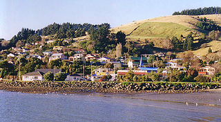
Macandrew Bay is located on the Otago Peninsula in the South Island of New Zealand. It is situated on the edge of Otago Harbour, and is named for pioneer European settler James Macandrew who lived here during his later life. The Te Reo Māori name for the bay, Te Roto Pāteke, refers to the Brown teal formerly prevalent in the area. Early European residents of the area called the bay "The Hundreds", due to the large number of boulders which covered the foreshore.

Fairfield is a suburb of Dunedin, New Zealand.
Pine Hill is a suburb, hill, and general area of the New Zealand city of Dunedin. It is sited on the hill of the same name, a spur of Mount Cargill overlooking North East Valley and Glenleith 4 kilometres (2.5 mi) to the north of the city centre. This spur lies in the fork of the confluence of the Water of Leith and its largest tributary, the Lindsay Creek. The term Pine Hill is used generally to refer to a group of suburbs which lie on the hill's slopes: Pine Hill suburb itself, which sits on the upper slopes of the spur, and also two other suburbs which lie on the lower slopes, Dalmore and Liberton.
Waikuku is a small town in the Canterbury region of New Zealand, which sits 28 km north of central Christchurch. Waikuku lies 11.8 km south of Leithfield on state highway 1 and 3 km north of Woodend. In 1901 there were 86 people resident in Waikuku according to that year's census. Waikuku settlement had a population of 156 people at the time of the 2018 Census. It is popular with both those that commute into work in Christchurch each day and with owners of holiday houses. Waikuku was home to rope and twine works. This business started off using flax from local swamps. It closed in 1987. The nearby sandy beach and pine forests are popular with surfers, swimmers, campers and horse-riders, and the large estuary of the Ashley River hosts many species of birds.
The township of Waihola lies between Dunedin and Milton, New Zealand in Otago, in New Zealand's South Island. It lies close to the southeast shore of the shallow tidal lake which shares its name.

The settlement of Broad Bay is located on the Otago Harbour coast of Otago Peninsula, in the South Island of New Zealand. It is administered as part of the city of Dunedin, and is technically a suburb of that city, though its isolation and semi-rural nature make it appear as a settlement in its own right.
Wakari is a residential suburb of the New Zealand city of Dunedin. It is located 2.5 kilometres (1.6 mi) to the northwest of the city centre, immediately to the west of the ridge which runs to the west of the city's centre. Wakari lies to the north of the upper reaches of the Kaikorai Valley, and is also north of the suburb of Kaikorai. The suburbs of Roslyn and Maori Hill are situated on the ridge immediately to the southeast and east of Wakari. The suburb of Halfway Bush lies to the northwest, and the smaller suburb of Helensburgh lies to the north.
Waldronville is a coastal settlement on the Pacific Ocean coast of the South Island of New Zealand. Established in the 1950s as a commuter settlement, it is located 13 kilometres (8.1 mi) to the southwest of Dunedin city centre, and lies within the city's limits. Waldronville was developed by Bill Waldron, when he purchased the McCraws farm in the early 1950s, initially for 200 houses. In the mid-1970s, two other streets were added to the southwest of the settlement. In the mid-1990s, Friendship Drive and Wavy Knowes developments were added to the northeast.

Sawyers Bay is a suburb of the New Zealand city of Dunedin. It is located 1.5 kilometres (0.93 mi) to the southwest of Port Chalmers in a wide valley on the shore of Mussel Bay, 13 kilometres (8.1 mi) to the northeast of Dunedin city centre.

Māori Hill is a residential suburb of the New Zealand city of Dunedin. It is located at the northern end of the ridge which runs in a crescent around the central city's western edge, 2 kilometres (1.2 mi) to the northwest of the city centre, immediately above and within the Town Belt. It is connected to Dunedin North, which lies to the east, via Drivers Road, the suburbs of Roslyn and Kaikorai to the southwest via Highgate, and the suburb of Wakari to the northwest via Balmacewen Road.
Calton Hill is an elevated southern residential suburb of the City of Dunedin in New Zealand's South Island. The suburb is named after Calton Hill in Edinburgh, Scotland, and some of its street names carry similar etymological roots.

Halfway Bush is a suburb of the New Zealand city of Dunedin. It is located 3 kilometres (1.9 mi) to the northwest of the city centre, close to the point at which Taieri Road becomes the winding rural Three Mile Hill Road. It was this road which gave the suburb its name, as this locality was halfway between the Taieri Plains and central Dunedin in the early days of European settlement, when Three Mile Hill was the main route from Dunedin to the Otago hinterland. This route was superseded by the route through the Caversham Valley in the 1860s.
Maryhill is a residential suburb of the New Zealand city of Dunedin. It is located on a ridge to the southwest of the central city between the suburbs of Mornington, Kenmure, and Caversham. The smaller suburb of Balaclava lies immediately to its west. Maryhill is believed to take its name from a district in the city of Glasgow in Scotland, where many of the early settlers of the suburb originated. In this regard it is unusual among Dunedin suburbs, many of which are named for suburbs of Edinburgh - Maryhill and the nearby Little Paisley are the only suburbs named for Glaswegian locations, and the latter is an old name rarely used today. A second theory is that Maryhill was named in honour of Mary, the wife of early Dunedin settler John Bathgate.
Brockville is a residential suburb of the New Zealand city of Dunedin. It is located at the edge of the city's main urban area, 5.5 kilometres (3.4 mi) to the northwest of the city centre, but separated from it by both a ridge of hills and the Kaikorai Valley.
Burnside is a mainly industrial suburb of the New Zealand city of Dunedin. It is located at the mouth of a long valley, the Kaikorai Valley, through which flows the Kaikorai Stream. This valley stretches to the northeast for 3.5 kilometres (2.2 mi). Burnside is 5.5 kilometres (3.4 mi) to the southwest of the city centre, close to eastern end of the much larger suburb, Green Island. Other suburbs located nearby include Concord, immediately to the southeast and Kenmure further up Kaikorai Valley.
Helensburgh is a suburb of the New Zealand city of Dunedin. It is located to the northwest of the city centre.
