Shiel Hill

Last updated

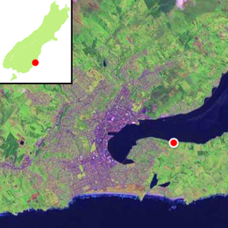
Shiel Hill is a residential suburb of the New Zealand city of Dunedin. It is located at the southeastern edge of the city's urban area, 3.2 kilometres (2.0 mi) southeast of the city's centre at the western end of the Otago Peninsula, close to the isthmus joining the peninsula to the mainland. As the name suggests, it is situated on the slopes of a hill at the start of the ridge which runs along the spine of the peninsula. The slopes rise to a series of crests generally known collectively as Highcliff, a name also often applied to the last suburban vestiges which remain as Dunedin's urban area becomes the rural land of the peninsula. More accurately, the name is that of a cliff which lies on the Pacific coast of the peninsula 4 kilometres (2.5 mi) east of Shiel Hill.

Dunedin City in Otago, New Zealand

Dunedin is the second-largest city in the South Island of New Zealand, and the principal city of the Otago region. Its name comes from Dùn Èideann, the Scottish Gaelic name for Edinburgh, the capital of Scotland.

Otago Peninsula peninsula

The Otago Peninsula is a long, hilly indented finger of land that forms the easternmost part of Dunedin, New Zealand. Volcanic in origin, it forms one wall of the eroded valley that now forms Otago Harbour. The peninsula lies south-east of Otago Harbour and runs parallel to the mainland for 20 km, with a maximum width of 9 km. It is joined to the mainland at the south-west end by a narrow isthmus about 1.5 km wide.

Isthmus Narrow strip of land connecting two larger land areas

An isthmus is a narrow piece of land connecting two larger areas across an expanse of water by which they are otherwise separated. A tombolo is an isthmus that consists of a spit or bar, and a strait is the sea counterpart of an isthmus.

The suburb is almost entirely residential, though there are some retail premises on the suburb's main road, Highcliff Road. These include a small nexus of shops at the southwestern edge of Shiel Hill, at the point where the suburb joins the neighbouring suburb of Andersons Bay. At this point, there is a road junction, with the western end of Highciff Road meeting four other roads, notably Silverton Street (which leads down into Andersons Bay and is the main route from Shiel Hill to central Dunedin) and Tomahawk Road (which leads to Dunedin's Pacific coastal suburbs of Tahuna and Ocean Grove).

Andersons Bay

Andersons Bay is a suburb of the New Zealand city of Dunedin. It is located in the southeast of the city's urban area, 2.8 kilometres (1.7 mi) southeast of the city's centre.

Pacific Ocean Ocean between Asia and Australia in the west, the Americas in the east and Antarctica or the Southern Ocean in the south.

The Pacific Ocean is the largest and deepest of Earth's oceanic divisions. It extends from the Arctic Ocean in the north to the Southern Ocean in the south and is bounded by Asia and Australia in the west and the Americas in the east.

Ocean Grove, New Zealand human settlement in New Zealand

Ocean Grove, also known as Tomahawk, is a suburb in the southeast of the New Zealand city of Dunedin. A semi-rural residential suburb on the Pacific coast at the southwestern end of the Otago Peninsula, Ocean Grove is located 6.5 kilometres (4.0 mi) southeast of Dunedin city centre.

Notable features of Shiel hill include Rotary Park, a small public reserve surrounding reservoirs which serve the Peninsula hill suburbs. This park is located above steep slopes which drop 166 metres (545 ft) to the waters of the Otago Harbour close to The Cove, half a kilometre to the north of the park. From Rotary Park, views can be obtained across and along the harbour to central Dunedin to the northwest, Signal Hill to the north, and Port Chalmers to the northeast. [1]

Port Chalmers human settlement in New Zealand

Port Chalmers is a suburb and the main port of the city of Dunedin, New Zealand, with a population of 3,000. Port Chalmers lies ten kilometres inside Otago Harbour, some 15 kilometres northeast from Dunedin's city centre.

The suburb of Shiel Hill hit the news headlines in Dunedin in 1995 after one of Dunedin's most notorious crimes was committed in Every Street, close to the boundary of Shiel Hill and Andersons Bay. The case, in which five of the six members of the Bain family were slain led to one of New Zealand's most prominent causes célèbres after the remaining member of the family, David Bain was arrested for the murders despite evidence indicating that the slayings may well have been a murder-suicide by his father Robin. David Bain was found guilty and served 13 years of a life sentence before succeeding in having the case reopened. His retrial, in 2009, resulted in a verdict of not guilty.

A cause célèbre is an issue or incident arousing widespread controversy, outside campaigning, and heated public debate. The term continues in the media in all senses. It is sometimes used positively for celebrated legal cases for their precedent value and more often negatively for infamous ones, whether for scale, outrage, scandal or conspiracy theories.

Highcliff

The small settlement of Challis sits at the harbour's edge below the Otago Peninsula Fallen Soldiers' Memorial, a major local landmark. ChallisNZ.jpg
The small settlement of Challis sits at the harbour's edge below the Otago Peninsula Fallen Soldiers' Memorial, a major local landmark.

East from Shiel Hill, Highcliff Road meets with McKerrow Street (which connects Shiel Hill with the neighbouring suburb of Waverley, before continuing along the spine of the peninsula, eventually descending at Portobello. Most parts of the peninsula between central Dunedin and Portobello which do not lie on the Otago Harbour coast are primarily accessible from this road. These places include Sandfly Bay, Pukehiki, Boulder Beach, and Hoopers Inlet. A second road to Ocean Grove, Centre Road, meets Highcliff Road 1.6 kilometres (0.99 mi) east of Shiel Hill. Though winding and often narrow, Highcliff Road is a popular route with tourists, as its location allows for views across the peninsula and harbour.

Portobello, New Zealand human settlement

Portobello is a village beside the Otago Harbour halfway along the Otago Peninsula in Dunedin City, New Zealand. It lies at the foot of a small peninsula between Portobello Bay and Latham Bay.

Otago Harbour The natural harbour of Dunedin, New Zealand

Otago Harbour is the natural harbour of Dunedin, New Zealand, consisting of a long, much-indented stretch of generally navigable water separating the Otago Peninsula from the mainland. They join at its southwest end, 21 km (13 mi) from the harbour mouth. It is home to Dunedin's two port facilities, Port Chalmers and at Dunedin's wharf. The harbour has been of significant economic importance for approximately 700 years, as a sheltered harbor and fishery, then deep water port.

Sandfly Bay

Sandfly Bay is a sandy bay with large dunes, located on the eastern side of the Otago Peninsula, New Zealand, 15 km east of central Dunedin. The bay is accessed from Seal Point Road or a walking track from Sandymount.

Prominent features of Highcliff Road which lie near Shiel Hill include the Otago Peninsula Fallen Soldiers' Memorial, a war memorial atop a 225-metre (738 ft) peak known as Arthur's Seat (after the similarly named prominence in Edinburgh, Scotland). This 10-metre-tall (33 ft) monument was designed by E. H. Walden and R.A. Hosie, and stands on a rocky promontory known as Cadzow Rock. It was unveiled in March 1923. [2] Owing to its location, at the top of the peninsula's westernmost promontory, it is visible from much of central Dunedin.

Arthurs Seat mountain in Edinburgh, Scotland

Arthur's Seat is the main peak of the group of hills in Edinburgh, Scotland, which form most of Holyrood Park, described by Robert Louis Stevenson as "a hill for magnitude, a mountain in virtue of its bold design". It is situated just to the east of the city centre, about 1 mile (1.6 km) to the east of Edinburgh Castle. The hill rises above the city to a height of 250.5 m (822 ft), provides excellent panoramic views of the city and beyond, is relatively easy to climb, and is popular for hillwalking. Though it can be climbed from almost any direction, the easiest and simplest ascent is from the east, where a grassy slope rises above Dunsapie Loch. At a spur of the hill, Salisbury Crags has historically been a rock climbing venue with routes of various degrees of difficulty, but due to hazards, rock climbing is now restricted to the South Quarry and a permit is required.

Edinburgh City and council area in Scotland

Edinburgh is the capital city of Scotland and one of its 32 council areas. Historically part of the county of Midlothian, it is located in Lothian on the Firth of Forth's southern shore.

Related Research Articles

Dunedin is a city of 130,700 people in the South Island of New Zealand. The principal suburbs of Dunedin are as follows. Inner and outer suburbs are ordered by location, clockwise from the city centre, starting due north:

Macandrew Bay human settlement in New Zealand

Macandrew Bay is located on the Otago Peninsula in the South Island of New Zealand. It is situated on the edge of Otago Harbour, and is named for pioneer settler James Macandrew who lived here during his later life. Early residents of the area called the bay "The Hundreds", due to the large number of boulders which covered the foreshore.

Lawyers Head

Lawyers Head is a prominent landmark on the coast of Otago, New Zealand. Located within the city of Dunedin, this rocky headland juts into the Pacific Ocean at the eastern end of the city's main beach, Saint Kilda Beach. It is named for the likeness of the cliff face to the profile of a lawyer in traditional legal wig.

Waverley, Dunedin

Waverley is a suburb of the New Zealand city of Dunedin. It was named after Sir Walter Scott's novel Waverley, first novel in a series known as the Waverley Novels, among the most popular and widely read English-language novels of the 19th century. Waverley is located at the start of the Otago Peninsula, 2.4 kilometres (1.5 mi) southeast of the city centre, on a rise overlooking the Otago Harbour to the north.

Broad Bay, New Zealand human settlement in New Zealand

The settlement of Broad Bay is located on the Otago Harbour coast of Otago Peninsula, in the South Island of New Zealand. It is administered as part of the city of Dunedin, and is technically a suburb of that city, though its isolation and semi-rural nature make it appear as a settlement in its own right.

Musselburgh, New Zealand

Musselburgh is a residential suburb of the New Zealand city of Dunedin. It is located in the southeast of the city's urban area, 2.8 kilometres (1.7 mi) southeast of the city's centre, and at the narrowest point of the isthmus which joins Otago Peninsula to the rest of the South Island. The suburb takes its name from the similarly named town in Scotland. Musselburgh's 2001 population was 2,835.

St Leonards, Dunedin Suburb of the New Zealand city of Dunedin

St Leonards is a suburb of the New Zealand city of Dunedin. It is located close to the northern shore of the Otago Harbour and on the hilly slopes above the harbour. St Leonards is 8.5 kilometres (5.3 mi) northeast of Dunedin's city centre, between the small settlement of Burkes and Sawyers Bay. St Leonards was named by early settler David Carey for the birthplace of his wife, the English town of St Leonards-on-Sea, on the Sussex coast.

South Dunedin

South Dunedin is a major inner city suburb of the New Zealand city of Dunedin. It is located, as its name suggests, 2.5 kilometres (1.6 mi) to the south of the city centre, on part of a large plain known locally simply as "The Flat". The suburb is a mix of industrial, retail, and predominantly lower-quality residential properties. South Dunedin's 2006 population was 2,490, a decrease of 48 people from 2001.

Ravensbourne, New Zealand

Ravensbourne is a suburb of the New Zealand city of Dunedin. It is located on the steep southeastern slopes of Signal Hill above the Otago Harbour. It lies on the harbour's northern shore, 4.5 kilometres (2.8 mi) east-northeast of the city centre. Ravensbourne's 2001 population was 1,269.

Victory Beach

Victory Beach is located on the Pacific Ocean coast of the Otago Peninsula, in the South Island of New Zealand, 24 kilometres (15 mi) by road from Dunedin city centre. The longest beach on the peninsula, Victory Beach is located northeast of the entrance to Papanui Inlet and stretches for 3.5 kilometres. It is backed by a series of high sand dunes. The beach's name derives from the wreck of the SS Victory on the beach in 1861. The beach and headlands to the north and south form Wickliffe Bay, itself named for the ship John Wickliffe, which – along with the Philip Laing – brought the first permanent European settlers to Otago.

Roseneath is a small suburb of the New Zealand city of Dunedin, located on the northwestern shore of Otago Harbour, 12 kilometres (7.5 mi) to the northeast of Dunedin city centre. It is situated between Saint Leonards and Port Chalmers on a rocky promontory of the same name which juts 0.6 kilometres (0.37 mi) into the harbour between Sawyers Bay and Blanket Bay. The suburb and promontory are likely to have been named from the similar location of Rosneath in Scotland.

Challis, New Zealand

Challis is a settlement on the Otago Harbour coast of Otago Peninsula, within the city limits of the New Zealand city of Dunedin. Though officially regarded as a suburb, the isolated nature of Challis means that most locals regard it as a separate settlement within the city limits.

Company Bay is a semi-residential suburb of Dunedin, New Zealand, located on the Otago Peninsula between Macandrew Bay and Broad Bay. Access to surrounding suburbs and the centre of the city is via Portobello Road, which skirts the edge of Otago Harbour. A smaller, winding road ascends from the bay, linking with the peninsula's ridge road close to Larnach Castle at Pukehiki.

Pukehiki human settlement in New Zealand

Pukehiki is a small locality on Otago Peninsula, within the city of Dunedin in the South Island of New Zealand. It is located on the ridge which runs along the centre of the peninsula, 8 kilometres (5.0 mi) from Dunedin city centre, at a junction between Highcliff Road, which runs along the peninsula's ridge, and Castlewood Road, which descends to Company Bay on the shore of the Otago Harbour.

Andersons Bay Cemetery

Andersons Bay Cemetery is a major cemetery in the New Zealand city of Dunedin. It is located 4 kilometres (2.5 mi) to the southeast of the city centre, on a rocky outcrop which forms the inland part of Lawyer's Head, a promontory which juts into the Pacific Ocean. The cemetery is bounded on the western and southern sides by Chisholm Park Golf Links, and to the east by steep slopes which descend to the Tomahawk Lagoon. Despite its name, the cemetery is located in the suburb of Tahuna, which lies immediately to the south of the suburb of Andersons Bay, and almost 1 kilometre (0.62 mi) from the former bay itself, at the head of the Otago Harbour.

References

  1. Hamel, A. (2007) Dunedin tracks and trails. Dunedin: Silver Peaks Press. ISBN   978-0-473-13772-4. p. 3-08
  2. Herd, J. and Griffiths, G.J. (1980) Discovering Dunedin. Dunedin: John McIndoe. ISBN   0-86868-030-3. p. 112

Coordinates: 45°53′30″S170°32′21″E / 45.8916°S 170.5393°E / -45.8916; 170.5393