
The Otago Peninsula is a long, hilly indented finger of land that forms the easternmost part of Dunedin, New Zealand. Volcanic in origin, it forms one wall of the eroded valley that now forms Otago Harbour. The peninsula lies south-east of Otago Harbour and runs parallel to the mainland for 20 km, with a maximum width of 9 km. It is joined to the mainland at the south-west end by a narrow isthmus about 1.5 km wide.

Otago Harbour is the natural harbour of Dunedin, New Zealand, consisting of a long, much-indented stretch of generally navigable water separating the Otago Peninsula from the mainland. They join at its southwest end, 21 km (13 mi) from the harbour mouth. It is home to Dunedin's two port facilities, Port Chalmers and at Dunedin's wharf. The harbour has been of significant economic importance for approximately 700 years, as a sheltered harbor and fishery, then deep water port.

The Waipori River is in Otago in the South Island of New Zealand. Rising in the Lammerlaw Range, it flows southeast for 50 kilometres (31 mi) before joining the Taieri River near Henley, 30 kilometres (19 mi) southwest of Dunedin of which it is officially the southernmost border. Google Maps erroneously shows the stretch of Taieri river from the confluence to the mouth as Waipori River. The correct name is shown on the New Zealand government's official NZ Topo Map.

Otakou is a settlement within the boundaries of the city of Dunedin, New Zealand. It is located 25 kilometres from the city centre at the eastern end of Otago Peninsula, close to the entrance of Otago Harbour. Though a small fishing village, Otakou is important in the history of Otago for several reasons. The settlement is the modern centre and traditional home of the Ōtākou rūnanga (assembly) of Ngāi Tahu. In 1946 Otakou Fisheries was founded in the township; this was later to become a major part of the Otago fishing industry.
Aramoana is a small coastal settlement 27 kilometres (17 mi) north of Dunedin on the South Island of New Zealand. The settlement's permanent population in the 2001 Census was 261. Supplementing this are seasonal visitors from the city who occupy cribs. The name Aramoana is Māori for "pathway of the sea".
Macandrew Bay is located on the Otago Peninsula in the South Island of New Zealand. It is situated on the edge of Otago Harbour, and is named for pioneer European settler James Macandrew who lived here during his later life. The Te Reo Māori name for the bay, Te Roto Pāteke, refers to the Brown teal formerly prevalent in the area. Early European residents of the area called the bay "The Hundreds", due to the large number of boulders which covered the foreshore.

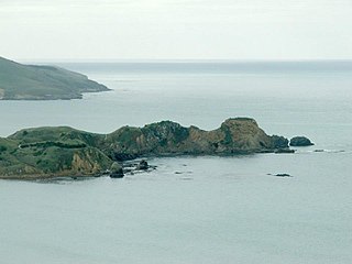
Taiaroa Head is a headland at the end of the Otago Peninsula in New Zealand, overlooking the mouth of the Otago Harbour. It lies within the city limits of Dunedin. The nearest settlement, Otakou, lies three kilometres to the south.

Andersons Bay is a suburb of the New Zealand city of Dunedin. It is located in the southeast of the city's urban area, 2.8 kilometres (1.7 mi) southeast of the city's centre.
Katiki is a small settlement in North Otago, New Zealand. It lies between the townships of Palmerston and Hampden on State Highway 1 at the northern end of Katiki Beach, close to the Moeraki Peninsula. The tip of the peninsula, Katiki Point, is the site of Katiki Point Lighthouse. The scenic reserve of Trotter's Gorge is located just inland of Katiki.

St Kilda is a suburb of the New Zealand city of Dunedin. A densely populated residential suburb, it lies on the southern part of the city's central plain, to the southwest of the head of the harbour and immediately north of Ocean Beach, parts of which are within the suburb and form its major geographical feature. Saint Kilda's 2001 population was 5,904.

Musselburgh is a residential suburb of the New Zealand city of Dunedin. It is located in the southeast of the city's urban area, 2.8 kilometres (1.7 mi) southeast of the city's centre, and at the narrowest point of the isthmus which joins Otago Peninsula to the rest of the South Island. The suburb takes its name from the similarly named town in Scotland. Musselburgh's 2001 population was 2,835.

Ocean Grove, also known as Tomahawk and Toma haka in Te Reo Maori, is a suburb in the southeast of the New Zealand city of Dunedin. A semi-rural residential suburb on the Pacific coast at the southwestern end of the Otago Peninsula, Ocean Grove is located 6.5 kilometres (4.0 mi) southeast of Dunedin city centre.

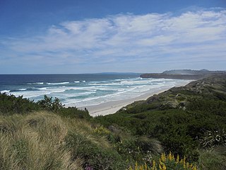
Victory Beach is located on the Pacific Ocean coast of the Otago Peninsula, in the South Island of New Zealand, 24 kilometres (15 mi) by road from Dunedin city centre and 7 kilometres (4.3 mi) from the nearby town of Portobello. The longest beach on the peninsula, Victory Beach is located northeast of the entrance to Papanui Inlet and stretches for 3.2 kilometres (2.0 mi). The beach's name derives from the wreck of the SS Victory on the beach in 1861.
Shiel Hill is a residential suburb of the New Zealand city of Dunedin. It is located at the southeastern edge of the city's urban area, 3.2 kilometres (2.0 mi) southeast of the city's centre at the western end of the Otago Peninsula, close to the isthmus joining the peninsula to the mainland. As the name suggests, it is situated on the slopes of a hill at the start of the ridge which runs along the spine of the peninsula. The slopes rise to a series of crests generally known collectively as Highcliff, a name also often applied to the last suburban vestiges which remain as Dunedin's urban area becomes the rural land of the peninsula. More accurately, the name is that of a cliff which lies on the Pacific coast of the peninsula 4 kilometres (2.5 mi) east of Shiel Hill.
Green Island is a small, uninhabited island lying 2 km off the coast of the Otago region of New Zealand, some 13 km south-west of the city of Dunedin. The island's Māori name is Okaihe.

Papanui Inlet is the northernmost of two large inlets in the Pacific coast of Otago Peninsula, in the South Island of New Zealand.
Huriawa, commonly known as Huriawa Peninsula or Karitane Peninsula, is a headland on the coast of Otago, New Zealand. It is located 35 kilometres north of Dunedin city centre, immediately to the southeast of the settlement of Karitane.

The Otago Heads is the historic name given to the headlands and coastal settlements close to the mouth of the long drowned volcanic rift which forms the Otago Harbour, in the South Island of New Zealand.
Tomahawk Beach is a beach on the Pacific Ocean 7.5 kilometres (4.7 mi) southeast of the city centre of Dunedin, New Zealand. Located within the Ocean Grove Reserve between St Kilda Beach and Smaills Beach, at the point where Otago Peninsula joins the mainland of the South Island, Tomahawk Beach is a white sand beach popular with casual beach-goers and dog-walkers as well as surfers. Sand is extracted from the Tomahawk Lagoon channel, which runs across the beach, for commercial purposes and to prevent flooding.

Allans Beach is a white sand beach on the Pacific Ocean coast of Otago Peninsula, in the South Island of New Zealand. It forms the seaward shore of a large spit at the entrance to Hoopers Inlet. Allans Beach is 25 kilometres (16 mi) by road from Dunedin city centre and 6 kilometres (3.7 mi) from the small town of Portobello. It receives little human traffic but is known to trampers, surfers, and naturists.
