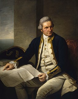
Cape Byron is the easternmost point of the mainland of Australia. It is about 3 km (1.9 mi) east of the town of Byron Bay and projects into the Pacific Ocean. The cape was named by British explorer Captain James Cook, when he passed the area on 15 May 1770, to honour British explorer John Byron who circumnavigated the globe in HMS Dolphin from 1764 to 1766. The Cape is part of the Cape Byron State Conservation Area.
The Taieri Plain are an area of fertile agricultural land to the southwest of Dunedin, in Otago, New Zealand. The plain covers an area of some 300 square kilometres, with a maximum extent of 30 kilometres.

Otakou is a settlement within the boundaries of the city of Dunedin, New Zealand. It is located 25 kilometres from the city centre at the eastern end of Otago Peninsula, close to the entrance of Otago Harbour. The settlement is the modern center and traditional home of the Ōtākou runanga of Ngai Tahu. In 1946 Otakou Fisheries was started based out of the township, this was later to become a major part of the Otago fishing industry.

The South West region is one of the nine regions of Western Australia. It is so named because it is located in the south-west corner of Western Australia. The South West region has an area of 23,970 km², and a population of about 170,000 people, which is predicted to rise to 217,000 people by 2023.

Taiaroa Head is a headland at the end of the Otago Peninsula in New Zealand, overlooking the mouth of the Otago Harbour. It lies within the city limits of Dunedin. The nearest settlement, Otakou, lies three kilometres to the south.

Smoky Cape is a headland in Australia on the New South Wales Mid-North Coast. It lies just east of the town of South West Rocks, and within the Hat Head National Park.

Lawyers Head is a prominent landmark on the coast of Otago, New Zealand. Located within the city of Dunedin, this rocky headland juts into the Pacific Ocean at the eastern end of the city's main beach, Saint Kilda Beach. It is named for the likeness of the cliff face to the profile of a lawyer in traditional legal wig.

Cape Capricorn is a coastal headland on Curtis Island, Gladstone Region, Queensland, Australia.
Katiki is a small settlement in North Otago, New Zealand. It lies between the townships of Palmerston and Hampden on State Highway 1 at the northern end of Katiki Beach, close to the Moeraki Peninsula. The tip of the peninsula, Katiki Point, is the site of Katiki Point Lighthouse. The scenic reserve of Trotter's Gorge is located just inland of Katiki.

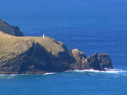
Nugget Point Lighthouse is a lighthouse at Nugget Point in the Otago region of the South Island of New Zealand. It is owned and operated by Maritime New Zealand.

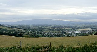
Saddle Hill is a prominent landmark overlooking the northeastern end of the Taieri Plains in Otago, New Zealand. Within the limits of Dunedin city, it is located 18 kilometres to the west of the city centre, between Mosgiel and Green Island, and is clearly visible from many of the city's southern hill suburbs. A lookout on the northern slopes of the hill commands a good view across the plains, with Lake Waihola visible 25 kilometres to the west in clear weather.

Victory Beach is located on the Pacific Ocean coast of the Otago Peninsula, in the South Island of New Zealand, 24 kilometres (15 mi) by road from Dunedin city centre. The longest beach on the peninsula, Victory Beach is located northeast of the entrance to Papanui Inlet and stretches for 3.5 kilometres. It is backed by a series of high sand dunes. The beach's name derives from the wreck of the SS Victory on the beach in 1861. The beach and headlands to the north and south form Wickliffe Bay, itself named for the ship John Wickliffe, which – along with the Philip Laing – brought the first permanent European settlers to Otago.

Pukehiki is a small locality on Otago Peninsula, within the city of Dunedin in the South Island of New Zealand. It is located on the ridge which runs along the centre of the peninsula, 8 kilometres (5.0 mi) from Dunedin city centre, at a junction between Highcliff Road, which runs along the peninsula's ridge, and Castlewood Road, which descends to Company Bay on the shore of the Otago Harbour.

MV Cape Don is a former lighthouse tender, now a museum ship in Waverton, New South Wales, Australia.

Papanui Inlet is the northernmost of two large inlets in the Pacific coast of Otago Peninsula, in the South Island of New Zealand.
Hoopers Inlet is one of two large inlets in the Pacific coast of Otago Peninsula, in the South Island of New Zealand.
James Melville Balfour was a Scottish-born New Zealand marine engineer. He is best remembered for the network of lighthouses that he designed. Balfour was a highly energetic man, who despite drowning after only six years in the country, has left an impressive list of projects either designed or constructed by him. He was initially employed by the Otago Provincial Council before his appointment by the Government of New Zealand as the colonial marine engineer.

The Otago Heads is the historic name given to the headlands and coastal settlements close to the mouth of the long drowned volcanic rift which forms the Otago Harbour, in the South Island of New Zealand.