Papanui Inlet

Last updated
Papanui Inlet (upper, right) and Hoopers Inlet (lower, left) are clearly visible on this NASA satellite photo of Otago Peninsula and Otago Harbour. Otago harbour landsat.jpg
Papanui Inlet (upper, right) and Hoopers Inlet (lower, left) are clearly visible on this NASA satellite photo of Otago Peninsula and Otago Harbour.
Looking north from near Cape Saunders past the mouth of Papanui Inlet to Victory Beach Cape Saunders Otago Peninsula.jpg
Looking north from near Cape Saunders past the mouth of Papanui Inlet to Victory Beach

Papanui Inlet is the northernmost of two large inlets in the Pacific coast of Otago Peninsula, in the South Island of New Zealand.

Pacific Ocean Ocean between Asia and Australia in the west, the Americas in the east and Antarctica or the Southern Ocean in the south.

The Pacific Ocean is the largest and deepest of Earth's oceanic divisions. It extends from the Arctic Ocean in the north to the Southern Ocean in the south and is bounded by Asia and Australia in the west and the Americas in the east.

Otago Peninsula peninsula

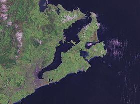
The Otago Peninsula is a long, hilly indented finger of land that forms the easternmost part of Dunedin, New Zealand. Volcanic in origin, it forms one wall of the eroded valley that now forms Otago Harbour. The peninsula lies south-east of Otago Harbour and runs parallel to the mainland for 20 km, with a maximum width of 9 km. It is joined to the mainland at the south-west end by a narrow isthmus about 1.5 km wide.

South Island Southernmost of the two main islands in New Zealand

The South Island, also officially named Te Waipounamu, is the larger of the two major islands of New Zealand in surface area; the other being the smaller but more populous North Island. It is bordered to the north by Cook Strait, to the west by the Tasman Sea, and to the south and east by the Pacific Ocean. The South Island covers 150,437 square kilometres (58,084 sq mi), making it the world's 12th-largest island. It has a temperate climate.

The inlet's name is of Māori origin, and means large plain (papa, flat land, and nui, big). [1] The name originally referred to the area of dunes and mudflats immediately to the north of the inlet, but was transferred to the inlet itself at the time of European settlement on the peninsula. [2] The inlet was also known by Māori as Makahoe. [3]

Māori language Polynesian language spoken by New Zealand Māori

Māori, also known as te reo, is an Eastern Polynesian language spoken by the Māori people, the indigenous population of New Zealand. Closely related to Cook Islands Māori, Tuamotuan, and Tahitian, it gained recognition as one of New Zealand's official languages in 1987. The number of speakers of the language has declined sharply since 1945, but a Māori language revitalisation effort slowed the decline, and the language has experienced a revival, particularly since about 2015.

Like its near neighbour, Hoopers Inlet, Papanui Inlet is known for its diverse bird life. The inlet lies 3 km to the east of Portobello. A short road linking the two inlets enables Papanui Inlet to be reached by road from both Portobello and the city of Dunedin (of which it is administratively a part), the centre of which lies 18 kilometres to the west. Both inlets are shallow, becoming predominantly sand and mud flats at low tide.

Hoopers Inlet bight in New Zealand

Hoopers Inlet is one of two large inlets in the Pacific coast of Otago Peninsula, in the South Island of New Zealand.

Portobello, New Zealand human settlement

Portobello is a village beside the Otago Harbour halfway along the Otago Peninsula in Dunedin City, New Zealand. It lies at the foot of a small peninsula between Portobello Bay and Latham Bay.

Dunedin City in Otago, New Zealand

Dunedin is the second-largest city in the South Island of New Zealand, and the principal city of the Otago region. Its name comes from Dùn Èideann, the Scottish Gaelic name for Edinburgh, the capital of Scotland.

The mouth of Papanui Inlet opens to the east, directly into the Pacific Ocean. While the southern shore of the inlet is flanked by steep hills, the northern shore is dominated by a large area of flat land known as Okia Flat, much of which is protected as Okia Reserve. [4] Beyond this lies Wickliffe Bay, which is bordered by Victory Beach, Otago Peninsula's longest beach. This flat land effectively narrows the mouth of the inlet. The remains of the 1861 wreck of the SS Victory (for which the beach is named) are still visible close to the inlet's mouth at low tide. Both this wreck and a historic midden close to the southern shore of the inlet's mouth are registered as Category II historic sites by the New Zealand Historic Places Trust. [5] [6]

Victory Beach

Victory Beach is located on the Pacific Ocean coast of the Otago Peninsula, in the South Island of New Zealand, 24 kilometres (15 mi) by road from Dunedin city centre. The longest beach on the peninsula, Victory Beach is located northeast of the entrance to Papanui Inlet and stretches for 3.5 kilometres. The beach's name derives from the wreck of the SS Victory on the beach in 1861.

Midden old dump for domestic waste

A midden is an old dump for domestic waste which may consist of animal bone, human excrement, botanical material, mollusc shells, sherds, lithics, and other artifacts and ecofacts associated with past human occupation.

Papanui Inlet is separated from Hoopers Inlet by a strip of land which is the isthmus to a hilly peninsula containing Cape Saunders and the peninsula's highest point, the 408-metre Mount Charles. A road, leading to Cape Saunders, skirts the southern shore of the inlet.

Cape Saunders

Kaimata, or Cape Saunders, is the prominent headland on the Pacific Ocean coast of Muaupoko, the Otago Peninsula, in the far south-east of Aotearoa New Zealand's Te Wai Pounamu, the South Island. It is home to the Cape Saunders Lighthouse.

The inlet is registered as a Coastal Protection Area by the Otago Regional Council, due to its cultural and spiritual values to the Kai Tahu iwi, its status as an important habitat for bird and sea life, and for its historic sites. [7]

Otago Regional Council

Otago Regional Council (ORC) is the regional council for Otago in the South Island of New Zealand. The council's principal office is Regional House on Stafford Street in Dunedin, with smaller offices in Queenstown and Alexandra.

Iwi are the largest social units in Aotearoa Māori society. The Māori-language word iwi means "people" or "nation", and is often translated as "tribe", or "a confederation of tribes". The word is both singular and plural in Māori.

Related Research Articles

Otago Harbour The natural harbour of Dunedin, New Zealand

Otago Harbour is the natural harbour of Dunedin, New Zealand, consisting of a long, much-indented stretch of generally navigable water separating the Otago Peninsula from the mainland. They join at its southwest end, 21 km (13 mi) from the harbour mouth. It is home to Dunedin's two port facilities, Port Chalmers and at Dunedin's wharf. The harbour has been of significant economic importance for approximately 700 years, as a sheltered harbor and fishery, then deep water port.

Port Chalmers Human settlement in New Zealand

Port Chalmers is a suburb and the main port of the city of Dunedin, New Zealand, with a population of 3,000. Port Chalmers lies ten kilometres inside Otago Harbour, some 15 kilometres northeast from Dunedin's city centre.

Otakou Place in Otago, New Zealand

Otakou is a settlement within the boundaries of the city of Dunedin, New Zealand. It is located 25 kilometres from the city centre at the eastern end of Otago Peninsula, close to the entrance of Otago Harbour. The settlement is the modern center and traditional home of the Ōtākou runanga of Ngai Tahu. In 1946 Otakou Fisheries was started based out of the township, this was later to become a major part of the Otago fishing industry.

Taieri Mouth human settlement in New Zealand

Taieri Mouth is a small fishing village at the mouth of the Taieri River, New Zealand. Taieri Island lies in the ocean several hundred metres off the river's mouth.

Macandrew Bay human settlement in New Zealand

Macandrew Bay is located on the Otago Peninsula in the South Island of New Zealand. It is situated on the edge of Otago Harbour, and is named for pioneer settler James Macandrew who lived here during his later life. Early residents of the area called the bay "The Hundreds", due to the large number of boulders which covered the foreshore.

Taiaroa Head

Taiaroa Head is a headland at the end of the Otago Peninsula in New Zealand, overlooking the mouth of the Otago Harbour. It lies within the city limits of Dunedin. The nearest settlement, Otakou, lies three kilometres to the south.

Portobello Marine Laboratory

The Portobello Marine Laboratory is located on the end of a short peninsula close to the township of Portobello, within the limits of the city of Dunedin in New Zealand's South Island. It is run as part of the University of Otago, the main campus of which is 23 kilometres to the southwest in Dunedin's main urban area.

Andersons Bay

Andersons Bay is a suburb of the New Zealand city of Dunedin. It is located in the southeast of the city's urban area, 2.8 kilometres (1.7 mi) southeast of the city's centre.

Waverley, Dunedin

Grants Braes redirects here

Goat Island / Rakiriri island

Goat Island/Rakiriri is an island in Otago Harbour in Otago, in the southern South Island of New Zealand. It is located between Port Chalmers and Portobello, to the northeast of Dunedin's city centre. It has one of New Zealand's dual placenames. The Maori language portion "Rakiriri" was a significant name brought by the original settlers from their Pacific homelands, a simple translation being "Angry Sky ". The name is also sometimes used to refer to the extinct Dunedin Volcano, of which Otago Harbour is the crater.

Broad Bay, New Zealand human settlement in New Zealand

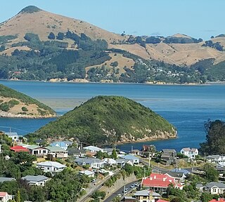
The settlement of Broad Bay is located on the Otago Harbour coast of Otago Peninsula, in the South Island of New Zealand. It is administered as part of the city of Dunedin, and is technically a suburb of that city, though its isolation and semi-rural nature make it appear as a settlement in its own right.

Musselburgh, New Zealand

Musselburgh is a residential suburb of the New Zealand city of Dunedin. It is located in the southeast of the city's urban area, 2.8 kilometres (1.7 mi) southeast of the city's centre, and at the narrowest point of the isthmus which joins Otago Peninsula to the rest of the South Island. The suburb takes its name from the similarly named town in Scotland. Musselburgh's 2001 population was 2,835.

South Dunedin

South Dunedin is a major inner city suburb of the New Zealand city of Dunedin. It is located, as its name suggests, 2.5 kilometres (1.6 mi) to the south of the city centre, on part of a large plain known locally simply as "The Flat". The suburb is a mix of industrial, retail, and predominantly lower-quality residential properties. South Dunedin's 2006 population was 2,490, a decrease of 48 people from 2001.

Challis, New Zealand

Challis is a settlement on the Otago Harbour coast of Otago Peninsula, within the city limits of the New Zealand city of Dunedin. Though officially regarded as a suburb, the isolated nature of Challis means that most locals regard it as a separate settlement within the city limits.

Huriawa Peninsula

Huriawa, commonly known as Huriawa Peninsula or Karitane Peninsula, is a headland on the coast of Otago, New Zealand. It is located 35 kilometres north of Dunedin city centre, immediately to the southeast of the settlement of Karitane.

Otago Heads

The Otago Heads is the historic name given to the headlands and coastal settlements close to the mouth of the long drowned volcanic rift which forms the Otago Harbour, in the South Island of New Zealand.

References

  1. Reed, A.W. (1975) Place names of New Zealand. Wellington: A.H. & A.W. Reed. p.319
  2. Goodall, M., and Griffiths, G. (1980) Maori Dunedin. Dunedin: Otago Heritage Books. ISBN   0-908774-45-1. p. 48.
  3. Goodall, M., and Griffiths, G. (1980) Maori Dunedin. Dunedin: Otago Heritage Books. ISBN   0-908774-45-1. p.45.
  4. "Super Sites for Conservation Education – Okia" (PDF). Department of Conservation. Retrieved 2009-09-12.
  5. "Wreck of SS Victory". Register of Historic Places. Heritage New Zealand.
  6. "Midden". Register of Historic Places. Heritage New Zealand.
  7. Schedule 2: Coastal protection Areas, Coastal Development Areas, Coastal Recreation Areas, and Coastal Harbourside Areas, Otago Regional Council Regional Plan (1 January 2012). Retrieved 28 May 2014.

Coordinates: 45°50′50″S170°41′40″E / 45.84722°S 170.69444°E / -45.84722; 170.69444