Dunedin is a city of 134,600people (June 2023) in the South Island of New Zealand.[1] The principal suburbs of Dunedin are as follows. Inner and outer suburbs are ordered by location, clockwise from the city centre, starting due north:
The centre of the city is The Octagon, an eight-sided plaza with a central carriageway. This is surrounded by another, larger octagonal street called Moray Place. The main retail area stretches north up George Street toward Dunedin North, and to a lesser extent south along Princes Street and east along Lower Stuart Street. At the end of Lower Stuart Street, 400 metres from the Octagon, lie Anzac Square and the Dunedin Railway Station, with an industrial area and the harbour beyond.
Half a kilometre south of the Octagon along Princes Street is The Exchange, at one time the site of the Dunedin Stock Exchange. The University of Otago was sited here for its first few years before moving to Dunedin North. It was originally called Custom House Square, still its official name.
The city's main retail and business area first grew here, at the intersection of Princes and Rattray Streets, with the main warehousing area immediately to the east, south of the roughly triangular park of Queens Gardens. This area, which has been largely renovated and beautified in the first years of the 21st century, is known as the Warehouse Precinct. Queens Gardens contains the city's main cenotaph. Close by this to the east lie the Otago Settlers Museum and Dunedin Chinese Garden. Beyond this are the docks at the head of the Otago Harbour. The area to the east of the railway from the docks north to the railway station has been the subject of long-term rejuvenation and redevelopment plans which may eventually see it turned into a district of boutique restaurants and shops.
The central business district has slowly moved north to George Street, although there has been some recent retail development in Crawford and Cumberland Streets, south and east of the Exchange. Immediately above and to the west of the central city is the hilly area known as City Rise, which contains many of the city's more impressive old houses. It is bounded from above by the Town Belt, one of the world's oldest green belts, designed by Charles Kettle in 1846.
Inner suburbs
The centre of Dunedin lies within a circle of hills broken only by the Otago Harbour and Ocean Beach, the latter being a long beach better known divided as St Clair, Middle St Kilda beaches. Suburbs within these hills and along their crest are usually regarded as inner while those beyond are outer. Since this distinction is largely by topography rather than true distance, several "outer suburbs" (such as Wakari and Halfway Bush) lie as close to the city centre as some inner suburbs (such as those in the North East and Leith Valleys) and share many of their features.
The main inner suburbs, clockwise from due north of the city centre, include the following:
Pine Hill is a southern spur of Mount Cargill, the 660-metre volcanic outcrop that dominates the northern end of Dunedin's urban area and is topped by the city's main television transmitter tower. The hill lies between the valleys of the Leith River (usually called the Water of Leith) to the west and its tributary Lindsay Creek to the east, and looks down across North East Valley. The Northern Motorway, part of State Highway 1 winds north around the hill's western flank. The suburb, which sits atop the spur, is four kilometres north of the city centre. Pine Hill's 2001 population was 2,259, including the older suburb of Dalmore to the south and the post-war state housing development of Liberton. The latter is home to Liberton Christian School, Dunedin's first special-character Protestant primary school. The upper section of Pine Hill (Campbells Road area) is often referred to as Pine Heights. Dalmore is also home to the annual Feastock festival held in a backyard on Fea Street.
The northern end of the city centre is designated Dunedin North. Its main features are the main campuses of Dunedin's two public tertiary institutions, the University of Otago and Otago Polytechnic, which are situated along the lower reaches of the Water of Leith. This river disgorges into the Otago Harbour in Dunedin North, close to one of the city's main parks, Logan Park (a reclaimed lake), which contains the Logan Park High School and the sporting facilities of the Caledonian Ground and University Oval. The city's main indoor sporting arena, Forsyth Barr Stadium is also located in Dunedin North, immediately to the southeast of Logan Park. Dunedin North's 2001 population, including the University area, was 7,047.
One of the city's oldest cemeteries, the Dunedin Northern Cemetery, is located in Dunedin North, as are the Dunedin Botanical Gardens. State Highway 1 joins the Dunedin road network at a busy intersection at the foot of Pine Hill and North East Valley at the "Gardens Corner", close to the Botanical Gardens' northwestern edge.
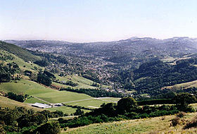
Looking down North East Valley towards Dunedin city
Lindsay Creek, a tributary of the Water of Leith, flows southwest down the long North East Valley at the northern end of Dunedin's urban area. This valley, lying between Pine Hill and Signal Hill, houses a residential suburb consisting of one main road with streets heading off it up the steep hills on either side. One of these streets, Baldwin Street, is listed as the world's steepest street. The original North East Valley post office was located near the foot of Baldwin Street, but was relocated to the Gardens to be nearer the retail area. North East Valley's 2001 population was 4,266.
The southern end of the valley is usually referred to as The Gardens or The Gardens Corner (The Dunedin Botanical Gardens are located nearby). The Gardens Corner contains one of Dunedin's main retail areas, and also one of its busiest road intersections - here the Northern Motorway (State Highway 1) joins Dunedin's one-way street system. This area includes Dunedin North Intermediate School and several University halls, notably Knox College and Salmond College.
Normanby is the name of the northern end of North East Valley, at which point Dunedin's urban area gives way to open countryside. The land here is steeply sloping, as it is the foothills of Mount Cargill. The slopes of Mount Cargill itself are densely wooded, and are crisscrossed with walking tracks, some of which start at the Bethune's Gully reserve, at the northern end of Normanby. Chingford Park, at the Normanby end of the valley is now a sports field and recreational reserve, but was originally the residence of one of Sam Neill's forebears, who was founder of Dunedin Company Wilson Neill. The large house is now gone, but the stone stables still on the site are impressive.
Mount Mera is an area of state housing sitting on the north facing side of the valley, just above Normanby.
Opoho suburb sits on the western flank of Signal Hill overlooking North East Valley and the Dunedin Botanic Gardens. It is a residential suburb with very mixed demographics, containing student flats, significant numbers of elderly citizens, and the houses of many in the academic community. Above the suburb sits the Centennial Lookout, a memorial built on the top of Signal Hill to mark the centenary of New Zealand in 1940. Impressive views over the city can be gained from here.
The suburb of Ravensbourne sits on the southern slopes of Signal Hill, close to the edge of the Otago Harbour. It is one of the older hill suburbs in the west harbour area of Dunedin. Separated from the inner city by a quarry at the eastern end of Logan Park. It is dominated by the Ravensdown fertiliser factory at the southern end of the suburb at the harbour's edge. Ravensbourne's 2001 population was 1,269.
Across the Harbour from Ravensbourne are (from north to south) Shiel Hill, Waverley, and Vauxhall. They form a continuous residential suburb at the western end of Otago Peninsula on the flank of Shiel Hill, overlooking Andersons Bay and the upper reaches of Otago Harbour.
Ocean Grove, formerly called Tomahawk (a name by which it is still widely known) lies on the south coast of the city end of Otago Peninsula, in and around the valley formed by the two-lobed Tomahawk Lagoon. It has much the feel of a separate settlement, as it is separated from sight of Dunedin by the bluff of Lawyers Head. Other than the lagoon, its main feature is Tomahawk Beach. The area was the site of coastal defences during World War II, and the remains of lookouts from the era can be found on a hill above the suburb. Ocean Grove is connected by road to Tahuna (which lies to the west), and via a steep road to the ridge road along the centre of Otago Peninsula.
Andersons Bay is a residential and light industrial zone to the south of the central city and east of South Dunedin. It extends along the former shoreline and across reclaimed land close to the head of the Otago Harbour, with its southernmost point being at the Andersons Bay Inlet at the foot of part of the Otago Peninsula. A major sports facility, The Edgar Centre, is located close to the harbour foreshore just to the north of Andersons Bay Inlet. Andersons Bay's 2001 population was 2,532. Dunedin's main cemetery, Andersons Bay Cemetery and the golf links of Chisholm Park are located in the smaller suburb of Tahuna, which lies to the south, close to the coastal promontory of Lawyers Head. Between the two is the small residential suburb of Tainui.
Musselburgh (named after the Scottish town) is located at the foot of the Otago Peninsula. It is at the narrowest point of the isthmus (at this point some 1,500 metres wide) connecting the Peninsula to the mainland. Musselburgh is dominated by a series of large rocky outcrops known as the Musselburgh Rise which stand above the eastern edge of the flat area of Saint Kilda. Musselburgh's 2001 population was 2,835.
South Dunedin is the city's second most important retail district, and lies immediately below the major road junction of Cargill's Corner some 2,500 metres south of the city centre. The main features of South Dunedin are the railway workshops which cover some 100,000 square metres (25 acres) at the northern edge of the suburb, and Carisbrook (the city's former main sports stadium), both of which straddle the border of South Dunedin and Caversham. At the northeastern edge of the suburb, closest to the city centre, is the small residential area of Kensington. South Dunedin's 2001 population was 2,538.
The beaches of St Kilda and St Clair—properly called Ocean Beach—stretch along the city's south coast for some 3,500 metres between Lawyers Head and Forbury Head. The suburb of St Kilda, which until 1989 was a separate borough, is a densely populated residential area stretching across the flat land between the beach and the light industrial areas to the south of the central city. St Kilda's 2001 population was 5,904. At the southern end of the suburb lies Forbury Park, the city's main horse racing (trotting and pacing) venue.
St Kilda has three pubs, a bowling green, a badminton hall as well as an Olympic-sized ice-skating rink. It is also the home of the St Kilda Sentinel Brass Band, Pirates Rugby Club, Otago Model Engineering Society, Ocean Beach Railway, the St Kilda Surf Lifesaving Club, and a Hot Rod club.
Five kilometres southwest of the city centre, St Clair lies on the lower slopes and at the foot of Forbury Hill. One of the city's wealthier suburbs, many fine houses are situated in the tree-clad slopes. Close to the summit of the hill is one of the city's top golf courses (St Clair Golf Course) and the ruins of Cargill's Castle. At the foot of the hill are St Clair Beach, a restaurant and resort complex, and an open-air heated salt-water swimming pool; the beach's sea wall, esplanade and oceanway were rebuilt and renovated in 2004. The beach is one of the South Island's more popular surfing venues and is also home to the St Clair Surf Life Saving Club. The small promontory of White Island lies three kilometres off the beach. The twin single-sex secondary schools of King's and Queen's lie close to the point where St Clair, St Kilda and Forbury meet. The smaller suburb of Forbury is located to the north of St Clair, between it and Caversham. St Clair's 2001 population was 4,179.
Close to the summit of Forbury Hill, and stretching out towards Saint Clair to the south and the outer suburb of Concord to the west is the large suburb of Corstorphine. This suburb, which contains a large proportion of state houses, was built during the 1930s-1950s. Lower down the hill to the east, close to Caversham and Forbury, lies the smaller but more prosperous suburb of Kew.
Calton Hill,[2] as its name suggests is an alleviated suburb on the south-western edge of 'inner' Dunedin. From Forbury Hill lies the spur known as Calton Hill which runs north into the Caversham Valley. Named after Calton Hill in Edinburgh, Scotland, the 'Township of Calton Hill' was gazetted on the 19 November 1910. There is currently no official census information for population of the suburb, but aerial maps suggest approximately 400-500 households. Five roads form its perimeter: Caversham Valley Road motorway to the north; Riselaw Road in the south-west; Corstophine Road in the south-east (until Sidey Street intersection); and Sidey Street/ Burnett Street in the north-east. The suburb contains 2-3 retail business, but is mainly residential. There is farmland on its south-western border, whilst the direct neighbour suburbs are Caversham, Corstophine, Concord and Lookout Point.
One of Dunedin's older suburban areas is Caversham, lying in a valley close to the Dunedin Southern Motorway (part of State Highway 1), the main transport access to Dunedin from the south. The suburb contains a small retail area, but is mainly residential. Carisbrook, the city's former main rugby venue, is situated at the eastern end of the suburb. This end of the suburb is dominated by one of Dunedin's largest industrial sites, the Hillside Railway Workshops. At the western end of the suburb, the valley rises steeply, culminating in a saddle of the motorway at Lookout Point. From here, there are views over the outer suburbs of Burnside, Green island, and Abbotsford. Caversham's 2001 population was 5,019.
Due west of the city centre, with primary access up High Street, sits the hill suburb of Mornington. Southwest of it is Maryhill, while Balaclava is a small locality to the west of Maryhill. Mornington was originally served by a cable car from The Exchange, with a connecting line running from Mornington to Maryhill.
Maryhill takes its name from a district in the city of Glasgow in Scotland, due to settlers from Maryhill in Scotland many years ago.
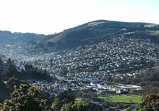
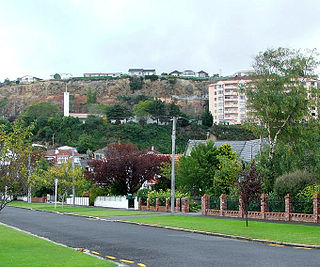
Looking from the Roslyn bridge, toward Dunedin City
The suburb of Roslyn lies atop a crest which forms part of the inner ring of hills around Dunedin. Excellent views of the inner city can be gained from the Roslyn overbridge, which is 1,500 metres northwest of the city centre, and 150 metres above sea level. Several of the city's most prestigious schools are located close to this suburb and its northern neighbour, Maori Hill. Its southwestern end merges imperceptibly into Belleknowes. Roslyn's 2001 population was 3,957.
Along with St Clair, Maori Hill is regarded as one of Dunedin's more exclusive suburbs. Many fine houses are located among the trees of the city's Town Belt, which snakes around the slopes of the crest which surrounds much of the inner city. Unlike neighbouring hill suburbs like Roslyn, Maori Hill was not served by a cable car, possibly underlying its greater degree of exclusivity. Maori Hill's 2001 population was 1,956. Prospect Park, a small suburb centred on the park of the same name, is sited at the northern end of the ridge which runs through the hill suburbs south to Lookout Point, overlooking the broad canyon of the Leith Valley.
At the northeastern end of the coastal plain that makes up the central city area, the Water of Leith forms a valley leading between Maori Hill and Pine Hill. In its lower reaches, this valley is broad, and is dominated by Woodhaugh Gardens. Much of Dunedin's water supply comes from reservoirs in the upper reaches of the Leith Valley. These include Ross Creek Reservoir, the oldest reservoir still in active use in New Zealand. Numerous popular walking tracks traverse the bush-clad reserve land surrounding this reservoir. Once a quarry, this is one of the city's oldest parks, dating from 1895. The area around the park is known as Woodhaugh and is a popular area for student accommodation, 15 minute walk to the university and the centre of the city. Beyond Woodhaugh, the valley narrows to become Glenleith, a residential suburb which follows the ribbon of the river. Past Glenleith is rough, undeveloped hill country, dotted by small farms. This area and the two suburbs of Glenleith and Woodhaugh is often collectively known simply as Leith Valley.
Outer suburbs
Many of the outer suburbs of Dunedin were separate towns until local government reorganisation in the late 1980s, and are still regarded as towns by some Dunedinites. The main outer suburbs, clockwise from the city centre (starting due north), include the following:
Beyond Ravensbourne on the main road to the mouth of the Otago Harbour and the town of Port Chalmers lie the two small settlements of Maia and Burkes (or Burkes Bay). Maia, whose name thought by casual observers to be of Māori origin, was actually named by a former mayor for a character from Greek mythology, Maia, one of the daughters of the TitanAtlas.
On the west bank of the Otago Harbour beyond Burkes, equidistant between Ravensbourne and Port Chalmers, lies the sleepy residential settlement of St Leonards. This was named by early settler David Carey (after whom Careys Bay, near Port Chalmers, was named) for St Leonards-on-Sea in England, which was the birthplace of his wife.[3] St Leonards' 2001 population was 729.
Dunedin is the second-largest city in the South Island of New Zealand, and the principal city of the Otago region. Its name comes from Dùn Èideann, the Scottish Gaelic name for Edinburgh, the capital of Scotland. The city has a rich Māori, Scottish, and Chinese heritage.
The Water of Leith, is a small river in the South Island of New Zealand.
Caversham is an association football club based in Dunedin, New Zealand. They compete in the ODT FootballSouth Premier League.
Lawyers Head is a prominent landmark on the coast of Otago, New Zealand. Located within the city of Dunedin, this rocky headland juts into the Pacific Ocean at the eastern end of the city's main beach, Saint Kilda Beach. It is named for the likeness of the cliff face to the profile of a lawyer in traditional legal wig.
The villages and then city that lay at the head of Otago Harbour never existed in isolation, but have always been a staging ground between inland Otago and the wider world. While Dunedin's current official city limits extend north to Waikouaiti, inland to Middlemarch and south to the Taieri River mouth, this articles focus is the history of the Dunedin urban area, only mentioning Mosgiel, the Otago Peninsula, Port Chalmers and inland Otago for context.
St Kilda is a suburb of the New Zealand city of Dunedin. A densely populated residential suburb, it lies on the southern part of the city's central plain, to the southwest of the head of the harbour and immediately north of Ocean Beach, parts of which are within the suburb and form its major geographical feature. Saint Kilda's 2001 population was 5,904.
Pine Hill is a suburb, hill, and general area of the New Zealand city of Dunedin. It is sited on the hill of the same name, a spur of Mount Cargill overlooking North East Valley and Glenleith 4 kilometres (2.5 mi) to the north of the city centre. This spur lies in the fork of the confluence of the Water of Leith and its largest tributary, the Lindsay Creek. The term Pine Hill is used generally to refer to a group of suburbs which lie on the hill's slopes: Pine Hill suburb itself, which sits on the upper slopes of the spur, and also two other suburbs which lie on the lower slopes, Dalmore and Liberton.
North East Valley is a suburb of the New Zealand city of Dunedin.
Dunedin North, also known as North Dunedin, is a major inner suburb of the New Zealand city of Dunedin, located 1.5 kilometres (0.93 mi) northeast of the city centre. It contains many of the city's major institutions, including the city's university, polytechnic, main hospital, and largest museum. Dunedin North's 2001 population was 7,047, including the university area.
St Clair is a leafy residential suburb of Dunedin, New Zealand. It is located on the Pacific Ocean coast five kilometres from the city centre on the southwesternmost part of the coastal plain which makes up the southern part of the urban area, and also climbs the slopes of Forbury Hill immediately to the west of this plain. St Clair's 2001 population was 4,179.
Caversham is one of the older suburbs (neighbourhoods) of the city of Dunedin, in New Zealand's South Island. It is sited at the western edge of the city's central plain at the mouth of the steep Caversham Valley, which rises to the saddle of Lookout Point. Major road and rail routes south lie nearby; the South Island Main Trunk railway runs through the suburb, and a bypass skirts its main retail area, connecting Dunedin's one-way street system with the Dunedin Southern Motorway. The suburb is linked by several bus routes to its neighbouring suburbs and central Dunedin.
Ōpoho is a suburb of the New Zealand city of Dunedin. It sits on the western flank of Signal Hill, 3 kilometres (1.9 mi) to the northeast of the city centre, overlooking North East Valley and the Dunedin Botanic Gardens.
South Dunedin is a major inner city suburb of the New Zealand city of Dunedin. It is located, as its name suggests, 2.5 kilometres (1.6 mi) to the south of the city centre, on part of a large plain known locally simply as "The Flat". The suburb is a mix of industrial, retail, and predominantly lower-quality residential properties.
Calton Hill is an elevated southern residential suburb of the City of Dunedin in New Zealand's South Island. The suburb is named after Calton Hill in Edinburgh, Scotland, and some of its street names carry similar etymological roots.
Forbury is a small residential suburb of the New Zealand city of Dunedin. It is 3 kilometres (1.9 mi) south-southwest of the city centre and lies immediately to the north of St Clair, between it and Caversham.
Corstorphine is a suburb of southwest Dunedin in the South Island of New Zealand. It is located on the slopes of Calton Hill - a spur of Forbury Hill - between Caversham Valley and the Pacific Ocean. The suburbs of Saint Clair and Forbury lie to the east and south, and Caversham and Lookout Point lie to the north.
Kensington is a small suburb of the New Zealand city of Dunedin, nestled to the south of a hilly spur between the central city and the major suburb of South Dunedin, some 2.4 kilometres (1.5 mi) to the south of the city centre. The suburb was named for the leafy London suburb, possibly by John Hyde Harris, who subdivided the area in the 1860s.
Shiel Hill is a residential suburb of the New Zealand city of Dunedin. It is located at the southeastern edge of the city's urban area, 3.2 kilometres (2.0 mi) southeast of the city's centre at the western end of the Otago Peninsula, close to the isthmus joining the peninsula to the mainland. As the name suggests, it is situated on the slopes of a hill at the start of the ridge which runs along the spine of the peninsula. The slopes rise to a series of crests generally known collectively as Highcliff, a name also often applied to the last suburban vestiges which remain as Dunedin's urban area becomes the rural land of the peninsula. More accurately, the name is that of a cliff which lies on the Pacific coast of the peninsula 4 kilometres (2.5 mi) east of Shiel Hill.
Leith Valley is a suburb, valley, and general area of the New Zealand city of Dunedin, located to the northwest of the city centre. To differentiate the name of the valley from that of the suburb, the former is usually referred to as the Leith Valley, the latter simply as Leith Valley.
On 3 June 2015, a low weather system brought heavy rain to the coastal Otago Region particularly South Dunedin. South Dunedin experienced heavy flooding, which was exacerbated by the area's high water table and the breakdown of the Portobello pumping station. 1,200 homes and businesses were damaged by flood damage. The Dunedin City Council (DCC) described the 3 June 2015 flood event as a "one in a 100 year" flood, with about 175mm of rain falling during a 24-hour period. The DCC subsequently drew criticism for the poor state of the city's storm water infrastructure.
This page is based on this Wikipedia article Text is available under the CC BY-SA 4.0 license; additional terms may apply. Images, videos and audio are available under their respective licenses.