
Waikouaiti is a small town in East Otago, New Zealand, within the city limits of Dunedin. The town is close to the coast and the mouth of the Waikouaiti River.

Dunedin is the second-largest city in the South Island of New Zealand, and the principal city of the Otago region. Its name comes from Dùn Èideann, the Scottish Gaelic name for Edinburgh, the capital of Scotland. The city has a rich Māori, Scottish, and Chinese heritage.

The small town of Karitane is located within the limits of the city of Dunedin in New Zealand, 35 kilometres to the north of the city centre.

The Dunedin School of Medicine is the name of the School of Medicine that is based on the Dunedin campus of the University of Otago. All University of Otago medical students who gain entry after the competitive Health Sciences First Year program, or who gain graduate entry, spend their second and third years studying at the Otago Medical School in Dunedin. In their fourth, fifth, and sixth years, students can either study at the Dunedin School of Medicine (Dunedin), the University of Otago, Christchurch, or the University of Otago, Wellington.

John Jones was a trader and settler in New Zealand.

Robert Arthur Lawson was one of New Zealand's pre-eminent 19th century architects. It has been said he did more than any other designer to shape the face of the Victorian era architecture of the city of Dunedin. He is the architect of over forty churches, including Dunedin's First Church for which he is best remembered, but also other buildings, such as Larnach Castle, a country house, with which he is also associated.

Sir Frederic Truby King, generally known as Truby King, was a New Zealand health reformer and Director of Child Welfare. He is best known as the founder of the Plunket Society.
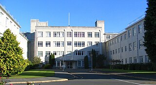
Wakari Hospital is a hospital located in Dunedin, New Zealand.
The Kilmog, occasionally called Kilmog Hill and known in Māori as Kirimoko, is a hilly area approximately 20 kilometres north of Dunedin, New Zealand, on State Highway 1, to the north of Blueskin Bay and south of Karitane. Technically more a series of hills than a single hill, it lies between the south branch of the Waikouaiti River and the Pacific Ocean, and reaches its highest point at the 431 m (1436 ft) Hammond Hill, close to the farming community of Merton. A second peak, Porteous Hill, lies at the southern end of the Kilmog, rising to 395 m (1317 ft).

Blueskin Bay is an estuary in coastal Otago, about 25 km north of Dunedin, New Zealand. The name also unofficially describes the rural district which includes the northern slopes of Mount Cargill, the southern slopes of the Kilmog, and the townships of Doctors Point, Waitati, Evansdale, Warrington, and Seacliff.
Seacliff is a small village located north of Dunedin in the Otago region of New Zealand's South Island. The village lies roughly halfway between the estuary of Blueskin Bay and the mouth of the Waikouaiti River at Karitane, on the eastern slopes of Kilmog hill. Coast Road, an old route north from Dunedin, and the South Island Main Trunk Railway pass through the village.
Evansdale is a locality on State Highway 1, 25 km north of Dunedin, at the north west of Blueskin Bay. It also has lent its name to a cheese producer, and a census-gathering district, which has a population of 1,482 in the 2013 New Zealand census, an increase of 198 people since the 2006 census.
Careys Creek, known in Māori as Whaitiripaku and Waihema, is a small river in Otago, New Zealand, which flows from the Silverpeaks into Blueskin Bay at Evansdale. The creek drains the forest plantations and native bush of Silverpeaks Forest and the Careys Creek Conservation Area. It is crossed by State Highway 1 at Evansdale, close to the foot of The Kilmog.
Evansdale is a census-gathering district in rural Dunedin, New Zealand. It encompasses all areas outside of urban areas between Mount Cargill and the northern Dunedin City boundary. It is named after one of the small villages it contains: Evansdale, New Zealand.
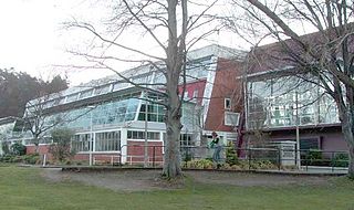
Moana Pool is the largest swimming pool in the southern half of New Zealand's South Island. It is located at the corner of Littlebourne Road and Upper Stuart Street close to Otago Boys' High School, on the slopes of Roslyn, overlooking the centre of the city of Dunedin. The pool complex can be seen from much of the city, and commands extensive views over central and coastal Dunedin.
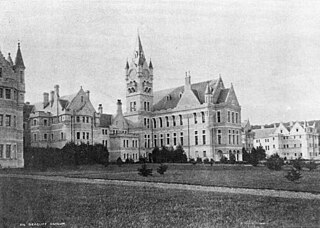
Seacliff Lunatic Asylum was a psychiatric hospital in Seacliff, New Zealand. When built in the late 19th century, it was the largest building in the country, noted for its scale and extravagant architecture. It became infamous for construction faults resulting in partial collapse, as well as a 1942 fire which destroyed a wooden outbuilding, claiming 37 lives, because the victims were trapped in a locked ward.

The Brattleboro Retreat is a private not-for-profit mental health hospital that provides comprehensive inpatient, partial hospitalization, and outpatient treatment services for children, adolescents, and adults.

Seacliff AFC was a soccer club based in the Otago region of New Zealand's South Island. They are notable for being the first team to win the Chatham Cup competition. They contested the final on later occasions in 1924, 1925, and 1929. Many of the team came from the staff of the Seacliff Lunatic Asylum; with the demise of the hospital in the 1940s, the team went into hiatus.

The Town Belt is a green belt which surrounds the centre of the New Zealand city of Dunedin. Covering a total of over 200 hectares, it extends around three sides of the city's centre at a distance from it of some 1-3 km in a broad 7 km crescent from the Oval at Kensington in the south through the suburbs of Mornington, City Rise, Belleknowes, Roslyn, Maori Hill, Prospect Park, Glenleith, Woodhaugh, The Gardens and Dunedin North and the slopes of Signal Hill. The fourth side of the central city is bounded by the Otago Harbour.

Matanaka Farm is near Waikouaiti in Otago, New Zealand. The five buildings are the oldest surviving farm buildings that are still in their original position in the country. The farm is owned and administered by Heritage New Zealand. Additionally the buildings are registered as Category I and are considered "historically outstanding".
