
The Clutha River is the second longest river in New Zealand and the longest in the South Island. It flows south-southeast 338 kilometres (210 mi) through Central and South Otago from Lake Wānaka in the Southern Alps to the Pacific Ocean, 75 kilometres (47 mi) south west of Dunedin. It is the highest volume river in New Zealand, and the swiftest, with a catchment of 21,000 square kilometres (8,100 sq mi), discharging a mean flow of 614 cubic metres per second (21,700 cu ft/s). The river is known for its scenery, gold-rush history, and swift turquoise waters. A river conservation group, the Clutha Mata-Au River Parkway Group, is working to establish a regional river parkway, with a trail, along the entire river corridor.

The Otago Peninsula is a long, hilly indented finger of land that forms the easternmost part of Dunedin, New Zealand. Volcanic in origin, it forms one wall of the eroded valley that now forms Otago Harbour. The peninsula lies south-east of Otago Harbour and runs parallel to the mainland for 20 km, with a maximum width of 9 km. It is joined to the mainland at the south-west end by a narrow isthmus about 1.5 km wide.

Otago Harbour is the natural harbour of Dunedin, New Zealand, consisting of a long, much-indented stretch of generally navigable water separating the Otago Peninsula from the mainland. They join at its southwest end, 21 km (13 mi) from the harbour mouth. It is home to Dunedin's two port facilities, Port Chalmers and at Dunedin's wharf. The harbour has been of significant economic importance for approximately 700 years, as a sheltered harbour and fishery, then deep water port.

Dunedin is the second-largest city in the South Island of New Zealand, and the principal city of the Otago region. Its name comes from Dùn Èideann, the Scottish Gaelic name for Edinburgh, the capital of Scotland. The city has a rich Māori, Scottish, and Chinese heritage.

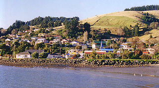
Otakou is a settlement within the boundaries of the city of Dunedin, New Zealand. It is located 25 kilometres from the city centre at the eastern end of Otago Peninsula, close to the entrance of Otago Harbour. Though a small fishing village, Otakou is important in the history of Otago for several reasons. The settlement is the modern centre and traditional home of the Ōtākou rūnanga (assembly) of Ngāi Tahu. In 1946 Otakou Fisheries was founded in the township; this was later to become a major part of the Otago fishing industry.

The town of Palmerston, in New Zealand's South Island, lies 50 kilometres to the north of the city of Dunedin. It is the largest town in the Waihemo Ward of the Waitaki District, with a population of 890 residents. Palmerston grew at a major road junction: State Highway 1 links Dunedin and Waikouaiti to the south with Oamaru and Christchurch to the north, while State Highway 85 heads inland to become the principal highway of the Maniototo. The Main South Line railway passes through the town and the Seasider tourist train travels from Dunedin to Palmerston and back once or twice a week. From 1880 until 1989, the town acted as the junction between the main line and a branch line that ran inland, the Dunback and Makareao Branches.

The Antipodes Islands are inhospitable and uninhabited volcanic islands in subantarctic waters to the south of – and territorially part of – New Zealand. The 21 km2 (8.1 sq mi) archipelago lies 860 km (530 mi) to the southeast of Stewart Island/Rakiura, and 730 km (450 mi) to the northeast of Campbell Island. They are very close to being the antipodal point to Normandy in France, meaning that the city farthest away is Cherbourg-en-Cotentin, France.
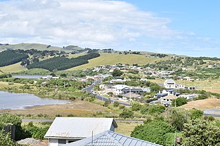
Macandrew Bay is located on the Otago Peninsula in the South Island of New Zealand. It is situated on the edge of Otago Harbour, and is named for pioneer Scottish settler James Macandrew who lived here during his later life. The Te Reo Māori name for the bay, Te Roto Pāteke, refers to the Brown teal formerly prevalent in the area. Early European residents of the area called the bay "The Hundreds", due to the large number of boulders which covered the foreshore.
William Tucker was a British convict, a sealer, a trader in human heads, an Otago settler, and New Zealand’s first art dealer.
There is a drastic decline in the number of ships visiting New Zealand from the previous year. An economic depression starts in New South Wales as a result of the escalation of war in Europe and the consequent reduction in the number of convicts being transported. In March news of the Boyd massacre reaches Port Jackson and a punitive expedition is sent to New Zealand and bombards the village of the incorrectly blamed chief, Te Pahi. After this the few whaling ships that later head for New Zealand usually prefer to avoid landing, especially in the Bay of Islands.
Foveaux Strait is the centre of attention for sealing ships. Sealing gangs are dropped along the coast from southern Fiordland to Otago Harbour and on Stewart Island/Rakiura. The Bay of Islands is sometimes on the journey to or from Port Jackson. The Chatham Islands are also visited. A few whalers also operate around New Zealand; some also collect timber from Bay of Islands.
The Sealers' War (1810–1821) in southern New Zealand, also known as the "War of the Shirt", was a series of often indiscriminate attacks and reprisals between Māori and European sealers. Initially minor misunderstandings between the two peoples quickly led to armed conflict. This resulted in a period of mistrust and animosity between Māori and sealers fueling several conflicts, leading to the deaths of about 74 people and the burning of the village of Otakou on the Otago Peninsula. Records exist from both sides of the conflict but not from any impartial observers.

St Clair is a leafy residential suburb of Dunedin, New Zealand. It is located on the Pacific Ocean coast five kilometres from the city centre on the southwesternmost part of the coastal plain which makes up the southern part of the urban area, and also climbs the slopes of Forbury Hill immediately to the west of this plain. St Clair's 2001 population was 4,179.
Ocean Grove, also known as Tomahawk, is a suburb in the southeast of the New Zealand city of Dunedin. A semi-rural residential suburb on the Pacific coast at the southwestern end of the Otago Peninsula, Ocean Grove is located 6.5 kilometres (4.0 mi) southeast of Dunedin city centre.

Tomahawk Lagoon is a twin-lobed lagoon, located at the western end of the Otago Peninsula within the city limits of Dunedin, New Zealand. It lies close to the southeastern edge of the city's main urban area, near the suburb of Ocean Grove, which lies close to its southern shore. This suburb was also known as Tomahawk until the 1930s.
Green Island is a small, uninhabited island lying 2 km off the coast of the Otago region of New Zealand, some 13 km south-west of the city of Dunedin. The island's Māori name is Ōkaihae.

Papanui Inlet is the northernmost of two large inlets in the Pacific coast of Otago Peninsula, in the South Island of New Zealand.
Hoopers Inlet is one of two large inlets in the Pacific coast of Otago Peninsula, in the South Island of New Zealand.
Huriawa, commonly known as Huriawa Peninsula or Karitane Peninsula, is a headland on the coast of Otago, New Zealand. It is located 35 kilometres north of Dunedin city centre, immediately to the southeast of the settlement of Karitane.

Smaills Beach is a beach on the Pacific Ocean 7.6 kilometres (4.7 mi) southeast of the city centre of Dunedin, New Zealand. Located within the Ocean Grove Reserve adjacent to Tomahawk Beach, at the point where Otago Peninsula joins the mainland of the South Island, Smaills Beach is a white sand beach for much of its length, but its western end is covered in volcanic boulders. Just offshore from the beach, dominating the wave patterns of the surf, is the rocky outcrop known as Bird Island. Smaills Beach is clothing-optional, renowned for its wildlife, and popular with surfers.

