Taiaroa Head

Last updated

Taiaroa Head Taiaroa Head 2.jpg
Taiaroa Head

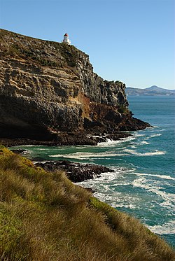
Taiaroa Head is a headland at the end of the Otago Peninsula in New Zealand, overlooking the mouth of the Otago Harbour. It lies within the city limits of Dunedin. The nearest settlement, Otakou, lies three kilometres to the south.

Contents

The cape is home to a lighthouse, built in 1864, and a colony of over 100 northern royal albatrosses, which established itself in 1919 [1] – the only such colony on an inhabited mainland. There is also the Royal Albatross Centre.

History

Armstrong RBL 6-inch disappearing gun at Taiaroa Head Disappearing Gun Taiaroa Head.jpg
Armstrong RBL 6-inch disappearing gun at Taiaroa Head

The headland is named for Te Mātenga Taiaroa, a 19th-century Māori chief of the Ngāi Tahu iwi. Pukekura, a significant Māori was located on the headland, having been established about 1650 and still occupied by Māori in the 1840s. It is associated with a daring warrior called Tarewai who was active in the 18th century. Pilot's Beach was formerly known as 'Hobart Town Beach' from the whaling tryworks established there in 1836 by the Weller brothers employing men from Hobart. Previously it was called 'Measly Beach' from its being a place where Māori went to bathe when afflicted by a measles epidemic in 1835. [2]

Historically, several commercial whaling stations established on the peninsula and the number of whales in this area were heavily exploited.

Ruins of former coastal defences are located nearby, notably a restored Armstrong disappearing gun emplacement built in 1886 following a scare that New Zealand might be invaded by the Russians.

Wildlife

Otago Harbour and the north-east tip of the Otago Peninsula as seen from Buttar's Peak, near Mount Cargill. TairoaHead.JPG
Otago Harbour and the north-east tip of the Otago Peninsula as seen from Buttar's Peak, near Mount Cargill.

A small beach, Pilots Beach, is located just inside the harbour entrance to the south of the head, and many forms of marine life, such as New Zealand fur seals and Hooker's sea lions are often to be seen. At Pilots beach is the largest colony of little or blue penguins remaining on the Otago Peninsula. Nearby are important breeding habitats of the threatened yellow-eyed penguin.

Northern royal albatross chick at Taiaroa Head Northern Royal Albatross chick Taiaroa Head.jpg
Northern royal albatross chick at Taiaroa Head

There may also be seen a number of dusky dolphins, orcas and migratory large whales such as southern rights and humpbacks. Their sightings in these areas are on the increase and Taiaroa Head may be one of the best vantage points along the Otago coast. The part of Taiaroa Head where northern royal albatrosses breed is managed by the NZ Department of Conservation as a nature reserve with restricted entry. On adjacent land the Otago Peninsula Trust manage a visitor centre and run guided tours into the Nature Reserve. Pilots Beach is managed as a recreation reserve by the Dunedin City. [2]

Royal albatross colony

The first albatross egg at the head was discovered in 1919, although it was not until 1938 that ornithologist Dr Lance Richdale saw the first live fledging. [1] Since they first successfully raised a chick at Taiaroa Head, royal albatross numbers have increased due to intensive management by reserve rangers. As time has progressed intensive wildlife husbandry methods such as are found in any threatened species programme have been developed and refined. The one important difference has been that both the adults and progeny are not held in captivity but in the wild and in the case of the adults leave the colony each day while raising chicks to gather food. Intensive methods include predator control for cats, ferrets, stoats and weasels. Also in the early 1990s a new blowfly arrived and caused the death of a number of chicks by laying eggs in them while the chick was still attempting to hatch. [3] Removing eggs from young or inexperienced parents has also occurred with these eggs being hatched in brooders. [4]

Notes

  1. 1 2 "Albatross colony marking 70 years". Otago Daily Times . 28 August 2008. Retrieved 30 August 2008.
  2. 1 2 "Taiaroa Head, OTAGO PENINSULA". New Zealand Historic Trust. Retrieved 25 July 2012.
  3. "Nature within the city". The Hindu . 2001. Archived from the original on 25 January 2013. Retrieved 25 July 2012.
  4. "Action Plan for Seabird Conservation in New Zealand" (PDF). New Zealand Department of Conservation. May 2000. Retrieved 25 July 2012.

Related Research Articles

<span class="mw-page-title-main">Otago Peninsula</span> Peninsula in New Zealand

The Otago Peninsula is a long, hilly indented finger of land that forms the easternmost part of Dunedin, New Zealand. Volcanic in origin, it forms one wall of the eroded valley that now forms Otago Harbour. The peninsula lies south-east of Otago Harbour and runs parallel to the mainland for 20 km, with a maximum width of 9 km. It is joined to the mainland at the south-west end by a narrow isthmus about 1.5 km wide.

<span class="mw-page-title-main">Otago Harbour</span> The natural harbour of Dunedin, New Zealand

Otago Harbour is the natural harbour of Dunedin, New Zealand, consisting of a long, much-indented stretch of generally navigable water separating the Otago Peninsula from the mainland. They join at its southwest end, 21 km (13 mi) from the harbour mouth. It is home to Dunedin's two port facilities, Port Chalmers and at Dunedin's wharf. The harbour has been of significant economic importance for approximately 700 years, as a sheltered harbour and fishery, then deep water port.

<span class="mw-page-title-main">Dunedin</span> City in Otago, New Zealand

Dunedin is the second-largest city in the South Island of New Zealand, and the principal city of the Otago region. Its name comes from Dùn Èideann, the Scottish Gaelic name for Edinburgh, the capital of Scotland. The city has a rich Māori, Scottish, and Chinese heritage.

<span class="mw-page-title-main">Port Chalmers</span> Main seaport of Dunedin, New Zealand

Port Chalmers is a town serving as the main port of the city of Dunedin, New Zealand. Port Chalmers lies ten kilometres inside Otago Harbour, some 15 kilometres northeast of Dunedin's city centre.

<span class="mw-page-title-main">Otakou</span> Place in Otago, New Zealand

Otakou is a settlement within the boundaries of the city of Dunedin, New Zealand. It is located 25 kilometres from the city centre at the eastern end of Otago Peninsula, close to the entrance of Otago Harbour. Though a small fishing village, Otakou is important in the history of Otago for several reasons. The settlement is the modern centre and traditional home of the Ōtākou rūnanga (assembly) of Ngāi Tahu. In 1946 Otakou Fisheries was founded in the township; this was later to become a major part of the Otago fishing industry.

<span class="mw-page-title-main">Moeraki</span> Village in Otago, New Zealand

Moeraki is a small fishing village on the east coast of the South Island of New Zealand. It was once the location of a whaling station. In the 1870s, local interests believed it could become the main port for the north Otago area and a railway line, the Moeraki Branch, was built to the settlement and opened in 1877. However, the port could not compete with Oamaru and the lack of traffic as well as stability problems caused by difficult terrain led to the closure of the railway in 1879 after only two years' operation.

<span class="mw-page-title-main">Taieri Island / Moturata</span>

Moturata, also called Taieri Island, is an island in the mouth of the Taieri River in southern New Zealand. It is connected to the mainland by a sandy causeway at low tide.

<span class="mw-page-title-main">Northern royal albatross</span> Species of bird

The northern royal albatross or toroa, is a large seabird in the albatross family. It was split from the closely related southern royal albatross as recently as 1998, though not all scientists support that conclusion and some consider both of them to be subspecies of the royal albatross.

<span class="mw-page-title-main">Lawyers Head</span> Headland in Dunedin, New Zealand

Lawyers Head is a prominent landmark on the coast of Otago, New Zealand. Located within the city of Dunedin, this rocky headland juts into the Pacific Ocean at the eastern end of the city's main beach, Saint Kilda Beach. It is named for the likeness of the cliff face to the profile of a lawyer in traditional legal wig.

The Weller brothers, Englishmen of Sydney, Australia, and Otago, New Zealand, were the founders of a whaling station on Otago Harbour and New Zealand's most substantial merchant traders in the 1830s.

<span class="mw-page-title-main">Harington Point</span> Settlement in Dunedin, New Zealand

The settlement of Harington Point lies within the boundaries of the city of Dunedin, New Zealand. It is located at the Otago Heads, at the northeastern end of Otago Peninsula, close to the entrance of Otago Harbour. The mouth of the harbour is at its narrowest at Harington Point, only some 400 metres separating the point from the mudflats at Aramoana on the opposing coast.

The Otago region of New Zealand is one of the more isolated places of the inhabited earth. Its high latitude, elevation and distance from larger foreign and domestic population centres have defined Otago at each stage of its history.

<span class="mw-page-title-main">Sandfly Bay</span>

Sandfly Bay is a sandy bay with large dunes 15 kilometres (9.3 mi) east of central Dunedin, New Zealand. Located on the southern side of Otago Peninsula, between Seal Point and the Gull Rocks on the western side of Sandymount, Sandfly Bay is a Department of Conservation wildlife reserve frequented by trampers.

<span class="mw-page-title-main">Boulder Beach</span>

Boulder Beach is a rocky beach on the Pacific Ocean, located on the south side of Otago Peninsula, some 15.7 kilometres (9.8 mi) by road east from central Dunedin, New Zealand. In addition to being relatively difficult to access physically due to the steepness of the surrounding country, it is closed to the public in the summer months (November–February) to protect the yellow-eyed penguins that nest on it.

<span class="mw-page-title-main">Victory Beach</span>

Victory Beach is located on the Pacific Ocean coast of the Otago Peninsula, in the South Island of New Zealand, 24 kilometres (15 mi) by road from Dunedin city centre and 7 kilometres (4.3 mi) from the nearby town of Portobello. The longest beach on the peninsula, Victory Beach is located northeast of the entrance to Papanui Inlet and stretches for 3.2 kilometres (2.0 mi). The beach's name derives from the wreck of the SS Victory on the beach in 1861.

<span class="mw-page-title-main">Huriawa Peninsula</span> Headland on the coast of New Zealand

Huriawa, commonly known as Huriawa Peninsula or Karitane Peninsula, is a headland on the coast of Otago, New Zealand. It is located 35 kilometres north of Dunedin city centre, immediately to the southeast of the settlement of Karitane.

<span class="mw-page-title-main">Otago Heads</span>

The Otago Heads is the historic name given to the headlands and coastal settlements close to the mouth of the long drowned volcanic rift which forms the Otago Harbour, in the South Island of New Zealand.

<span class="mw-page-title-main">Tomahawk Beach</span> Beach on the Pacific Ocean in Dunedin, New Zealand

Tomahawk Beach is a beach on the Pacific Ocean 7.5 kilometres (4.7 mi) southeast of the city centre of Dunedin, New Zealand. Located within the Ocean Grove Reserve between St Kilda Beach and Smaills Beach, at the point where Otago Peninsula joins the mainland of the South Island, Tomahawk Beach is a white sand beach popular with casual beach-goers and dog-walkers as well as surfers. Sand is extracted from the Tomahawk Lagoon channel, which runs across the beach, for commercial purposes and to prevent flooding.

<span class="mw-page-title-main">Allans Beach</span> Beach in Otago Region, New Zealand

Allans Beach is a white sand beach on the Pacific Ocean coast of Otago Peninsula, in the South Island of New Zealand. It forms the seaward shore of a large spit at the entrance to Hoopers Inlet. Allans Beach is 25 kilometres (16 mi) by road from Dunedin city centre and 6 kilometres (3.7 mi) from the small town of Portobello. It receives little human traffic but is known to trampers, surfers, and naturists.

Whareakeake is a beach 25 kilometres (16 mi) northeast of Dunedin in the South Island of New Zealand, as well as the valley above and behind the beach. Located to the west of Aramoana and included as a section of the Otago Heads, Whareakeake was a place of habitation for Māori people from early times until the Sealers' War skirmish of 1817 from which it derived its colonial name. It is now a surfing beach renowned for its right-hand point break.

References

Further reading

45°46′30″S170°43′40″E / 45.77500°S 170.72778°E / -45.77500; 170.72778