
The Clutha River is the second longest river in New Zealand and the longest in the South Island. It flows south-southeast 338 kilometres (210 mi) through Central and South Otago from Lake Wānaka in the Southern Alps to the Pacific Ocean, 75 kilometres (47 mi) south west of Dunedin. It is the highest volume river in New Zealand, and the swiftest, with a catchment of 21,960 square kilometres (8,480 sq mi), discharging a mean flow of 614 cubic metres per second (21,700 cu ft/s). The river is known for its scenery, gold-rush history, and swift turquoise waters. A river conservation group, the Clutha Mata-Au River Parkway Group, is working to establish a regional river parkway, with a trail, along the entire river corridor.
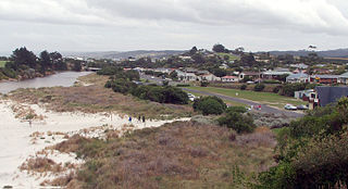
Brighton is a small seaside town within the city limits of Dunedin on New Zealand's South Island. It is located 20 kilometres southwest from the city centre on the Southern Scenic Route. The town faces a small bay which includes a broad sheltered beach. Other beaches extend from here. They make the area popular for summer day trips from Dunedin.
Dunedin is a city of 130,400 people in the South Island of New Zealand. The principal suburbs of Dunedin are as follows. Inner and outer suburbs are ordered by location, clockwise from the city centre, starting due north:

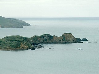
Taiaroa Head is a headland at the end of the Otago Peninsula in New Zealand, overlooking the mouth of the Otago Harbour. It lies within the city limits of Dunedin. The nearest settlement, Otakou, lies three kilometres to the south.

Lawyers Head is a prominent landmark on the coast of Otago, New Zealand. Located within the city of Dunedin, this rocky headland juts into the Pacific Ocean at the eastern end of the city's main beach, Saint Kilda Beach. It is named for the likeness of the cliff face to the profile of a lawyer in traditional legal wig.
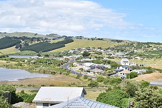
Long Beach, known in Māori as Warauwerawera, is a small coastal settlement in Otago, New Zealand comprising approximately 100 homes. Many of the sections were initially auctioned in October 1922 for a pound deposit. It is located within the city limits of Dunedin, and lies 15 kilometres northeast of the city centre, between Blueskin Bay and the mouth of the Otago Harbour. The small settlement of Pūrākaunui is located nearby.

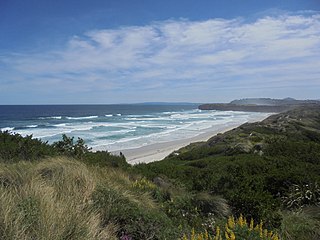
Sandfly Bay is a sandy bay with large dunes 15 kilometres (9.3 mi) east of central Dunedin, New Zealand. Located on the southern side of Otago Peninsula, between Seal Point and the Gull Rocks on the western side of Sandymount, Sandfly Bay is a Department of Conservation wildlife reserve frequented by trampers.

Boulder Beach is a rocky beach on the Pacific Ocean, located on the south side of Otago Peninsula, some 15.7 kilometres (9.8 mi) by road east from central Dunedin, New Zealand. In addition to being relatively difficult to access physically due to the steepness of the surrounding country, it is closed to the public in the summer months (November–February) to protect the yellow-eyed penguins that nest on it.

St Clair is a leafy residential suburb of Dunedin, New Zealand. It is located on the Pacific Ocean coast five kilometres from the city centre on the southwesternmost part of the coastal plain which makes up the southern part of the urban area, and also climbs the slopes of Forbury Hill immediately to the west of this plain. St Clair's 2001 population was 4,179.
Waldronville is a coastal settlement on the Pacific Ocean coast of the South Island of New Zealand. Established in the 1950s as a commuter settlement, it is located 13 kilometres (8.1 mi) to the southwest of Dunedin city centre, and lies within the city's limits. Waldronville was developed by Bill Waldron, when he purchased the McCraws farm in the early 1950s, initially for 200 houses. In the mid-1970s, two other streets were added to the southwest of the settlement. In the mid-1990s, Friendship Drive and Wavy Knowes developments were added to the northeast.
Ocean Grove, also known as Tomahawk, is a suburb in the southeast of the New Zealand city of Dunedin. A semi-rural residential suburb on the Pacific coast at the southwestern end of the Otago Peninsula, Ocean Grove is located 6.5 kilometres (4.0 mi) southeast of Dunedin city centre.
Shiel Hill is a residential suburb of the New Zealand city of Dunedin. It is located at the southeastern edge of the city's urban area, 3.2 kilometres (2.0 mi) southeast of the city's centre at the western end of the Otago Peninsula, close to the isthmus joining the peninsula to the mainland. As the name suggests, it is situated on the slopes of a hill at the start of the ridge which runs along the spine of the peninsula. The slopes rise to a series of crests generally known collectively as Highcliff, a name also often applied to the last suburban vestiges which remain as Dunedin's urban area becomes the rural land of the peninsula. More accurately, the name is that of a cliff which lies on the Pacific coast of the peninsula 4 kilometres (2.5 mi) east of Shiel Hill.

Papanui Inlet is the northernmost of two large inlets in the Pacific coast of Otago Peninsula, in the South Island of New Zealand.
Huriawa, commonly known as Huriawa Peninsula or Karitane Peninsula, is a headland on the coast of Otago, New Zealand. It is located 35 kilometres north of Dunedin city centre, immediately to the southeast of the settlement of Karitane.
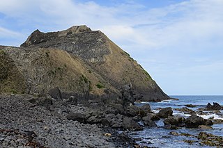
Blackhead is a promontory on the coast of Otago, New Zealand. It lies within the city limits of Dunedin, some 10 kilometres (6.2 mi) southwest of the city centre. The promontory extends some 500 metres into the ocean, and rises to a height of a little over 100 metres (330 ft). Māori names for Blackhead include Te Wai o Tinarau and Makereatu.

Smaills Beach is a beach on the Pacific Ocean 7.6 kilometres (4.7 mi) southeast of the city centre of Dunedin, New Zealand. Located within the Ocean Grove Reserve adjacent to Tomahawk Beach, at the point where Otago Peninsula joins the mainland of the South Island, Smaills Beach is a white sand beach for much of its length, but its western end is covered in volcanic boulders. Just offshore from the beach, dominating the wave patterns of the surf, is the rocky outcrop known as Bird Island. Smaills Beach is clothing-optional, renowned for its wildlife, and popular with surfers.
Tomahawk Beach is a beach on the Pacific Ocean 7.5 kilometres (4.7 mi) southeast of the city centre of Dunedin, New Zealand. Located within the Ocean Grove Reserve between St Kilda Beach and Smaills Beach, at the point where Otago Peninsula joins the mainland of the South Island, Tomahawk Beach is a white sand beach popular with casual beach-goers and dog-walkers as well as surfers. Sand is extracted from the Tomahawk Lagoon channel, which runs across the beach, for commercial purposes and to prevent flooding.
Whareakeake is a beach 25 kilometres (16 mi) northeast of Dunedin in the South Island of New Zealand, as well as the valley above and behind the beach. Located to the west of Aramoana and included as a section of the Otago Heads, Whareakeake was a place of habitation for Māori people from early times until the Sealers' War skirmish of 1817 from which it derived its colonial name. It is now a surfing beach renowned for its right-hand point break.
Hawksbury Lagoon is situated within the East Otago town of Waikouaiti, on the northern boundary of Dunedin City, New Zealand.

Tauparikākā Marine Reserve is a marine reserve located offshore about 20 kilometres (12 mi) north of Haast on the West Coast of New Zealand's South Island. It covers the area immediately offshore from Ship Creek, which is also known as Tauparikākā in Māori.


