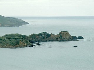
Lawyers Head seen from the east. Forbury Hill (upper right) and Blackhead (extreme top left) can be seen in the background
Lawyers Head (often punctuated as the more grammatically correct Lawyer's Head) is a prominent landmark on the coast of Otago, New Zealand.[1] Located within the city of Dunedin, this rocky headland juts into the Pacific Ocean at the eastern end of the city's main beach, Saint Kilda Beach. It is named for the likeness of the cliff face to the profile of a lawyer in traditional legal wig.
The promontory, which reaches a height of 34m, is connected to the city by the road John Wilson Ocean Drive, which runs parallel to the beach. The head itself commands a view across the city's southern suburbs and along the Otago coast for over 80 kilometres to the southwest. On a clear day Nugget Point in The Catlins can be discerned, and the Nugget Point lighthouse's beam can be seen at night. To the east, the suburb of Ocean Grove and the nearby Tomahawk Lagoon lie beneath the headland.
John Wilson Ocean Drive was closed from August 2006, to allow construction of the Tahuna Wastewater Treatment Plant outfall. The road closure had an unexpected benefit of stopping suicides from the headland; there were 13 deaths in the 10 years prior. Access to the headland was restored briefly in October 2009, but closed when there was another death less than three days after full access was restored. New Zealand Police Inspector Dave Campbell stated "Lawyer's Head now has the unenviable reputation of having the highest number of deaths by suicide in one location in New Zealand".[2]
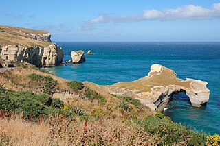
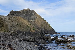
One of a series of headlands which punctuate much of this section of the Otago coast, it is its proximity to the centre of the city and its distinctive shape which make it particularly well known. Other nearby headlands nearby include the higher 75m Maori Head, one kilometre to the east, the cliffs along the coast of Forbury Hill three kilometres to the west, the natural arch of Tunnel Beach three kilometres beyond Forbury Hill, and Blackhead two kilometres to the southwest of Tunnel Beach.
These basalt outcrops were all formed during the eruption of the Dunedin Volcano some 12-15 million years ago. The crater of this long-extinct volcano now forms Otago Harbour, and its rim is the ring of hills which circle Dunedin and form the ridge of the Otago Peninsula.
Lawyers Head is an integral part of Chisholm Park Golf Links, developed by the city of Dunedin in 1933. The Links has hosted the New Zealand amateur championship, the New Zealand Masters teams event, and many Australasian Tour events and Pro-ams. The course boasts several holes rated among Otago's best, including the ninth hole, also named "Lawyers Head", which is arguably the country's finest hole.[3] This hole follows the curve of the cliffs, such that a direct line between tee and cup passes over the waters below.
The promontory is also located close to Andersons Bay Cemetery, which lies immediately inland from Lawyers Head.
↑ "Moral Dilemma"(PDF). City Talk. Dunedin City Council: 16–18. March 2010. Archived from the original(PDF) on 2010-05-14. Retrieved 2010-03-19.
↑ Russell, P. G. (1985) Golf Courses of Otago. Christchurch: Whitcoulls Publishers. ISBN0-7233-0752-0.
Further reading
Bishop, D.G., and Turnbull, I.M. (compilers) (1996). Geology of the Dunedin Area. Lower Hutt, NZ: Institute of Geological & Nuclear Sciences. ISBN0-478-09521-X.
Dann, C., and Peat, N. (1989). Dunedin, North and South Otago. Wellington: GP Books. ISBN978-0-477-01438-0.
The ruins of Cargill's Castle stand on a promontory overlooking the Pacific Ocean in New Zealand's southern city of Dunedin. It is one of about ten castles in New Zealand, the other one in Otago being nearby Larnach Castle. More a castle in name than in fact, this Italianate mansion was built for Edward Cargill, eighth child of city founder William Cargill, in the late 19th century, who called it The Cliffs. Designed by the young architect Francis Petre, and built in concrete by Harry Lyders at a cost of £14,000, it was completed in 1877. Several kilometres south of the castle is Tunnel Beach, so named because this quiet beach is only accessible through a steeply sloping tunnel cut into the 60 metres (200 ft) high cliffs by the Cargill family. It is also very likely that Petre was the supervisor of the construction of the tunnel. While designing the house, Petre fell in love with Cargill's daughter Margaret. After a difficult courtship the couple were eventually permitted to marry, the wedding taking place in the villa's principal salon on 1 March 1881.
Dunedin is a city of 134,600 people in the South Island of New Zealand. The principal suburbs of Dunedin are as follows. Inner and outer suburbs are ordered by location, clockwise from the city centre, starting due north:
The Ocean Beach Railway (OBR) is a heritage railway that operates in Dunedin, New Zealand. It is located between John Wilson Drive in the suburb of Saint Kilda and sports grounds near Forbury Park Raceway, and runs parallel with the city's main beach, Ocean Beach. This is near where the Ocean Beach Branch once ran, but not on the same formation.
Taiaroa Head is a headland at the end of the Otago Peninsula in New Zealand, overlooking the mouth of the Otago Harbour. It lies within the city limits of Dunedin. The nearest settlement, Otakou, lies three kilometres to the south.
Tunnel Beach is a locality 7.5 kilometres (4.7 mi) southwest of the city centre of Dunedin, New Zealand. Located just south of St Clair, Tunnel Beach has sea-carved sandstone cliffs, rock arches and caves. Beyond the beauty of the rugged sandstone cliffs, its claim to fame is the tunnel down to the beach that a local politician, John Cargill, son of Captain William Cargill, had commissioned for his family in the 1870s. Local legend says that one or more of Cargill's daughters drowned while swimming at the beach, but there is no truth to this story.
Sandfly Bay is a sandy bay with large dunes 15 kilometres (9.3 mi) east of central Dunedin, New Zealand. Located on the southern side of Otago Peninsula, between Seal Point and the Gull Rocks on the western side of Sandymount, Sandfly Bay is a Department of Conservation wildlife reserve frequented by trampers.
Boulder Beach is a rocky beach on the Pacific Ocean, located on the south side of Otago Peninsula, some 15.7 kilometres (9.8 mi) by road east from central Dunedin, New Zealand. In addition to being relatively difficult to access physically due to the steepness of the surrounding country, it is closed to the public in the summer months (November–February) to protect the yellow-eyed penguins that nest on it.
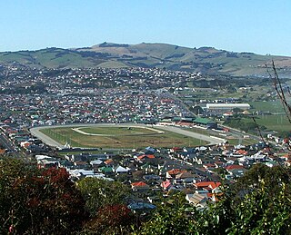
Forbury Park Raceway was a horseracing venue in the New Zealand city of Dunedin until its closure in 2021. It was located close to the Pacific Ocean coast in the suburb of Saint Kilda.
St Clair is a leafy residential suburb of Dunedin, New Zealand. It is located on the Pacific Ocean coast five kilometres from the city centre on the southwesternmost part of the coastal plain which makes up the southern part of the urban area, and also climbs the slopes of Forbury Hill immediately to the west of this plain. St Clair's 2001 population was 4,179.
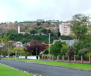
Caversham is one of the older suburbs of the city of Dunedin, in New Zealand's South Island. It is sited at the western edge of the city's central plain at the mouth of the steep Caversham Valley, which rises to the saddle of Lookout Point. Major road and rail routes south lie nearby; the South Island Main Trunk railway runs through the suburb, and a bypass skirts its main retail area, connecting Dunedin's one-way street system with the Dunedin Southern Motorway. The suburb is linked by several bus routes to its neighbouring suburbs and central Dunedin.
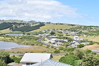
Ocean Grove, also known as Tomahawk, is a suburb in the southeast of the New Zealand city of Dunedin. A semi-rural residential suburb on the Pacific coast at the southwestern end of the Otago Peninsula, Ocean Grove is located 6.5 kilometres (4.0 mi) southeast of Dunedin city centre.
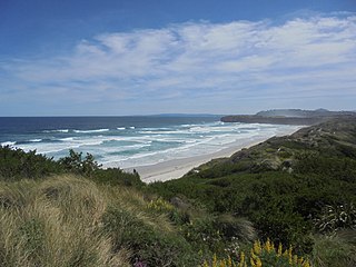
Ocean Beach is a long sandy beach which runs along the Pacific Ocean coast of south Dunedin, New Zealand. It stretches for some three kilometres from Saint Clair in the southwest along the coast of Saint Kilda to the foot of Lawyers Head in the east. The beach is a popular recreation area for swimming, surfing, and walking.
Victory Beach is located on the Pacific Ocean coast of the Otago Peninsula, in the South Island of New Zealand, 24 kilometres (15 mi) by road from Dunedin city centre and 7 kilometres (4.3 mi) from the nearby town of Portobello. The longest beach on the peninsula, Victory Beach is located northeast of the entrance to Papanui Inlet and stretches for 3.2 kilometres (2.0 mi). The beach's name derives from the wreck of the SS Victory on the beach in 1861.
Forbury is a small residential suburb of the New Zealand city of Dunedin. It is 3 kilometres (1.9 mi) south-southwest of the city centre and lies immediately to the north of St Clair, between it and Caversham.
Andersons Bay Cemetery is a major cemetery in the New Zealand city of Dunedin. It is located 4 kilometres (2.5 mi) to the southeast of the city centre, on a rocky outcrop which forms the inland part of Lawyers Head, a promontory which juts into the Pacific Ocean. The cemetery is bounded on the western and southern sides by Chisholm Park Golf Links, and to the east by steep slopes which descend to the Tomahawk Lagoon. Despite its name, the cemetery is located in the suburb of Tahuna, which lies immediately to the south of the suburb of Andersons Bay, and almost 1 kilometre (0.62 mi) from the former bay itself, at the head of the Otago Harbour.
Chisholm Park is a golf club and links course in the New Zealand city of Dunedin. It is located in the southern coastal suburb of Tahuna, close to Andersons Bay Cemetery and the coastal headland of Lawyers Head.
Huriawa, commonly known as Huriawa Peninsula or Karitane Peninsula, is a headland on the coast of Otago, New Zealand. It is located 35 kilometres north of Dunedin city centre, immediately to the southeast of the settlement of Karitane.
Blackhead is a promontory on the coast of Otago, New Zealand. It lies within the city limits of Dunedin, some 10 kilometres (6.2 mi) southwest of the city centre. The promontory extends some 500 metres into the ocean, and rises to a height of a little over 100 metres (330 ft). Māori names for Blackhead include Te Wai o Tinarau and Makereatu.
Smaills Beach is a beach on the Pacific Ocean 7.6 kilometres (4.7 mi) southeast of the city centre of Dunedin, New Zealand. Located within the Ocean Grove Reserve adjacent to Tomahawk Beach, at the point where Otago Peninsula joins the mainland of the South Island, Smaills Beach is a white sand beach for much of its length, but its western end is covered in volcanic boulders. Just offshore from the beach, dominating the wave patterns of the surf, is the rocky outcrop known as Bird Island. Smaills Beach is clothing-optional, renowned for its wildlife, and popular with surfers.
Tomahawk Beach is a beach on the Pacific Ocean 7.5 kilometres (4.7 mi) southeast of the city centre of Dunedin, New Zealand. Located within the Ocean Grove Reserve between St Kilda Beach and Smaills Beach, at the point where Otago Peninsula joins the mainland of the South Island, Tomahawk Beach is a white sand beach popular with casual beach-goers and dog-walkers as well as surfers. Sand is extracted from the Tomahawk Lagoon channel, which runs across the beach, for commercial purposes and to prevent flooding.
This page is based on this Wikipedia article Text is available under the CC BY-SA 4.0 license; additional terms may apply. Images, videos and audio are available under their respective licenses.