Related Research Articles

Otago is a region of New Zealand located in the southern half of the South Island administered by the Otago Regional Council. It has an area of approximately 32,000 square kilometres (12,000 sq mi), making it the country's second largest local government region. Its population was 245,300 in June 2020.

Queenstown is a resort town in Otago in the south-west of New Zealand's South Island. It has an urban population of 16,000.

Alexandra is a town in the Central Otago district of the South Island of New Zealand. It is on the banks of the Clutha River, on State Highway 8, 188 kilometres (117 mi) by road from Dunedin and 33 kilometres (21 mi) south of Cromwell. The nearest towns to Alexandra via state highway 8 are Clyde seven kilometers to the northwest and Roxburgh forty kilometers to the south. State highway 85 also connects Alexandra to Omakau, Lauder, Oturehua, Ranfurly and on to Palmerston on the East Otago coast.

Timaru is a port city in the southern Canterbury region of New Zealand, located 157 kilometres (98 mi) southwest of Christchurch and about 196 kilometres (122 mi) northeast of Dunedin on the eastern Pacific coast of the South Island. The Timaru urban area is home to 28,700 people, and is the largest urban area in South Canterbury, and the second largest in the Canterbury Region overall, after Christchurch. The town is the seat of the Timaru District, which includes the surrounding rural area and the towns of Geraldine, Pleasant Point and Temuka, which combined have a total population of 48,400.

Dunedin is the second-largest city in the South Island of New Zealand, and the principal city of the Otago region. Its name comes from Dùn Èideann, the Scottish Gaelic name for Edinburgh, the capital of Scotland.

The Catlins comprises an area in the southeastern corner of the South Island of New Zealand. The area lies between Balclutha and Invercargill, straddling the boundary between the Otago and Southland regions. It includes the South Island's southernmost point, Slope Point.
Dunedin is a city of 134,100 people in the South Island of New Zealand. The principal suburbs of Dunedin are as follows. Inner and outer suburbs are ordered by location, clockwise from the city centre, starting due north:

Shinnecock Hills Golf Club is a links-style golf club located in an unincorporated area of the Town of Southampton on Long Island, New York, situated between the Peconic Bay and the Atlantic Ocean.
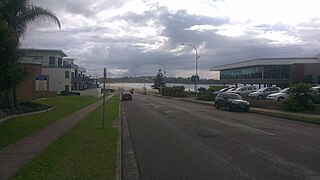
Mollymook is located on the South Coast of New South Wales, Australia approximately three hours' drive south of Sydney within the City of Shoalhaven local government area. At the 2016 census, Mollymook had a population of 1,083 while the adjacent locality of Mollymook Beach was home to a further 2,447 people. Geographically, Mollymook is considered part of the Milton-Ulladulla district, a coastal corridor of urban development stretching from Burrill Lake, south of Ulladulla to Mollymook's northern neighbour, Narrawallee and the historic town of Milton a few kilometres inland.

The New Zealand Open is the premier men's golf tournament in New Zealand. It has been a regular fixture on the PGA Tour of Australasia tournament schedule since the 1970s. The 2019 event was the 100th edition of the tournament. Since 2014 it has been held as a pro-am in February or March.

Lawyers Head is a prominent landmark on the coast of Otago, New Zealand. Located within the city of Dunedin, this rocky headland juts into the Pacific Ocean at the eastern end of the city's main beach, Saint Kilda Beach. It is named for the likeness of the cliff face to the profile of a lawyer in traditional legal wig.
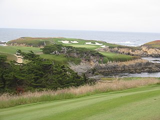
Cypress Point Club is a private golf club on the West Coast of the United States, along the Central Coast of California. The club has a single 18-hole course, one of eight on the Monterey Peninsula near Monterey. The course is well known for a series of dramatic holes along the Pacific Ocean that have been named as some of the best in golf. It is part of S.M.A.C. a collection of the most exclusive golf/country clubs in america; and possibly planet Earth as well.

Andersons Bay is a suburb of the New Zealand city of Dunedin. It is located in the southeast of the city's urban area, 2.8 kilometres (1.7 mi) southeast of the city's centre.

St Kilda is a suburb of the New Zealand city of Dunedin. A densely populated residential suburb, it lies on the southern part of the city's central plain, to the southwest of the head of the harbour and immediately north of Ocean Beach, parts of which are within the suburb and form its major geographical feature. Saint Kilda's 2001 population was 5,904.
The following lists events that happened during 1872 in New Zealand.

St Clair is a leafy residential suburb of Dunedin, New Zealand. It is located on the Pacific Ocean coast five kilometres from the city centre on the southwesternmost part of the coastal plain which makes up the southern part of the urban area, and also climbs the slopes of Forbury Hill immediately to the west of this plain. St Clair's 2001 population was 4,179.

Ocean Grove, also known as Tomahawk and Toma haka in Te Reo Maori, is a suburb in the southeast of the New Zealand city of Dunedin. A semi-rural residential suburb on the Pacific coast at the southwestern end of the Otago Peninsula, Ocean Grove is located 6.5 kilometres (4.0 mi) southeast of Dunedin city centre.

The Kaikorai Stream is a short river which runs through the city of Dunedin, in New Zealand's South Island.

Andersons Bay Cemetery is a major cemetery in the New Zealand city of Dunedin. It is located 4 kilometres (2.5 mi) to the southeast of the city centre, on a rocky outcrop which forms the inland part of Lawyer's Head, a promontory which juts into the Pacific Ocean. The cemetery is bounded on the western and southern sides by Chisholm Park Golf Links, and to the east by steep slopes which descend to the Tomahawk Lagoon. Despite its name, the cemetery is located in the suburb of Tahuna, which lies immediately to the south of the suburb of Andersons Bay, and almost 1 kilometre (0.62 mi) from the former bay itself, at the head of the Otago Harbour.
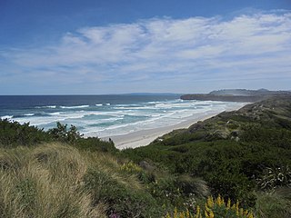
Tomahawk Beach is a beach on the Pacific Ocean 7.5 kilometres (4.7 mi) southeast of the city centre of Dunedin, New Zealand. Located within the Ocean Grove Reserve between St Kilda Beach and Smaills Beach, at the point where Otago Peninsula joins the mainland of the South Island, Tomahawk Beach is a white sand beach popular with casual beach-goers and dog-walkers as well as surfers. Sand is extracted from the Tomahawk Lagoon channel, which runs across the beach, for commercial purposes and to prevent flooding.
References
- 1 2 History - Chisholm Links, club website. Retrieved 27 January 2018.
- ↑ "Historic Cemeteries Conservation Trust of New Zealand". cemeteries.org.nz. Retrieved 21 May 2021.
- ↑ "Undervalued Chisholm Park links worth investing in and promoting," Otago Daily Times , 6 August 2013. Retrieved 27 January 2018.
- 1 2 Russell, P. G. (1985) Golf courses of Otago, Christchurch: Whitcoulls Publications. p. 14. ISBN 0-7233-0752-0
- ↑ van Royen, R. "Golf: Head professional credits members for new job," Otago Daily Times, 16 May 2015. retrieved 27 January 2018.