
Waikouaiti is a small town in East Otago, New Zealand, within the city limits of Dunedin. The town is close to the coast and the mouth of the Waikouaiti River.

Dunedin is the second-largest city in the South Island of New Zealand, and the principal city of the Otago region. Its name comes from Dùn Èideann, the Scottish Gaelic name for Edinburgh, the capital of Scotland. The city has a rich Māori, Scottish, and Chinese heritage.
East Otago is the name given to that part of Otago, in the South Island of New Zealand that lies directly to the north of Dunedin. To the south, its limit is approximately the rough hill pass of the Kilmog, 25 kilometres north of Dunedin city centre, and in the north the limit is the Shag River.

The small town of Karitane is located within the limits of the city of Dunedin in New Zealand, 35 kilometres to the north of the city centre.

The Silverpeaks is an area of rough forest and tussock and scrub covered hill country inland and to the northwest of Dunedin, New Zealand. The area is largely uninhabited; the main indication of human activity is the Taieri Gorge Railway, which preserves the route of the former Otago Central Railway that runs along the steep-sided valley of the Taieri River. Much of the area lies within the Silverpeaks Scenic Reserve.
Hawksbury, also known as Cherry Farm, is a small residential and industrial area in New Zealand, located beside State Highway 1 between Dunedin and Waikouaiti.
Waikouaiti was a parliamentary electorate in the Otago region of New Zealand, from 1866 to 1908.
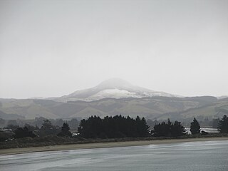
Mount Watkin / Hikaroroa is a 616-metre peak located north-west of Waikouaiti, Otago, New Zealand. It is on the east side of the North Branch of the Waikouaiti River.
The Gold Fields District electorate was a 19th-century parliamentary electorate in the Otago region, New Zealand. It was created in 1862, with the first elections in the following year, and it returned two members. It was one of eventually three special interest constituencies created to meet the needs of gold miners. All three of these electorates were abolished in 1870. A unique feature of the Gold Fields District was that it was superimposed over other electorates, and voting was open to those who had held a mining license for some time. As such, suffrage was more relaxed than elsewhere in New Zealand, as voting was otherwise tied to property ownership. Another feature unique to the gold mining electorates was that no electoral rolls were prepared, but voting could be done upon showing a complying miner's license.

Edmund Giblett Allen (1844–1909) was a Liberal Party Member of Parliament in New Zealand.
William Dick Murison was a 19th-century New Zealand Member of Parliament, journalist and cricketer.
Robert Mitchell was a 19th-century Member of Parliament from Otago, New Zealand.
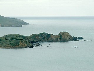
Huriawa, commonly known as Huriawa Peninsula or Karitane Peninsula, is a headland on the coast of Otago, New Zealand. It is located 35 kilometres north of Dunedin city centre, immediately to the southeast of the settlement of Karitane.
The 1868 Waikouaiti by-election was a by-election held on 27 July 1868 in the Waikouaiti electorate during the 4th New Zealand Parliament.
The 1869 Waikouaiti by-election was a by-election held on 27 April 1869 in the Waikouaiti electorate during the 4th New Zealand Parliament.
The 1872 Waikouaiti by-election was a by-election held on 12 June 1872 in the Waikouaiti electorate during the 5th New Zealand Parliament.
The 1873 Waikouaiti by-election was a by-election held on 23 July 1873 in the Waikouaiti electorate during the 5th New Zealand Parliament.
The 1875 Waikouaiti by-election was a by-election held on 3 May 1875 in the Waikouaiti electorate during the 5th New Zealand Parliament.
In February 2021, the East Otago towns of Waikouaiti and Karitane in New Zealand reported high lead levels in their water supplies. Local and national authorities responded by dispatching water tanks and staff to assist local residents and offering them free blood tests, fruits and vegetables. The lead poisoning scare also attracted covered by national media. By 10 March 2021, the Southern District Health Board confirmed that test results indicated that long term exposure to lead in the water supply posed minimial risk to the local population.
Hawksbury Lagoon is situated within the East Otago town of Waikouaiti, on the northern boundary of Dunedin City, New Zealand.


