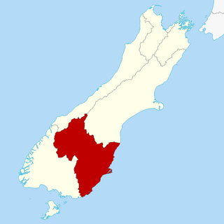
East Otago is the name given to that part of Otago, in the South Island of New Zealand that lies directly to the north of Dunedin. To the south, its limit is approximately the rough hill pass of the Kilmog, 25 kilometres north of Dunedin city centre, and in the north the limit is the Shag River.
The population of East Otago is 2,500 (est 2001)
Expected population in 2006 is 3,000 with 1,400 expecting to live in the Main town of Waikouaiti
Census provisional count for East Otago as of 2006 was 4,991
Census provisional count for East Otago towns was:
Otago is a region of New Zealand located in the southern half of the South Island administered by the Otago Regional Council. It has an area of approximately 32,000 square kilometres (12,000 sq mi), making it the country's second largest local government region. Its population was 254,600 in June 2023.
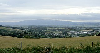
Waikouaiti is a small town in East Otago, New Zealand, within the city limits of Dunedin. The town is close to the coast and the mouth of the Waikouaiti River.
Dunedin is the second-largest city in the South Island of New Zealand, and the principal city of the Otago region. Its name comes from Dùn Èideann, the Scottish Gaelic name for Edinburgh, the capital of Scotland. The city has a rich Māori, Scottish, and Chinese heritage.
The Taieri Plain is an area of fertile agricultural land to the southwest of Dunedin, in Otago, New Zealand. The plain covers an area of some 300 square kilometres, with a maximum extent of 30 kilometres. It is not to be confused with Strath Taieri, a second plain of the Taieri River, 40kms to the north beyond Mount Ross.
The Waikouaiti River is found to the north of Dunedin in Otago, New Zealand. It flows to the Pacific Ocean at Karitane, close to the town of Waikouaiti.
The small town of Karitane is located within the limits of the city of Dunedin in New Zealand, 35 kilometres to the north of the city centre.
Palmerston is a town in the South Island of New Zealand. Located 50 kilometres to the north of the city of Dunedin, it is the largest town in the Waihemo Ward of the Waitaki District, with a population of 890 residents. Palmerston grew at a major road junction: State Highway 1 links Dunedin and Waikouaiti to the south with Oamaru and Christchurch to the north, while State Highway 85 heads inland to become the principal highway of the Maniototo. The Main South Line railway passes through the town and the Seasider tourist train travels from Dunedin to Palmerston and back once or twice a week. From 1880 until 1989, the town acted as the junction between the main line and a branch line that ran inland, the Dunback and Makareao Branches.
The Strath Taieri is a large glacial valley and river plateau in New Zealand's South Island. It is surrounded by the rugged hill ranges to the north and west of Otago Harbour. Since 1989 it has been part of the city of Dunedin. The small town of Middlemarch is located at its southern end.
Dunback, formerly Waihemo, is a small town in the Otago region of New Zealand. It is located between Palmerston and Ranfurly on Highway 85. It has a population of about 200 people. Most of these people live in the rural areas near the town.
Waitati, from the Māori Waitete, is a small seaside settlement in Otago, New Zealand, within the city limits of Dunedin. It is located close to the tidal mudflats of Blueskin Bay, 19 kilometres north of the Dunedin city centre. The small Waitati River flows through the bay to the sea.
The Kilmog, occasionally called Kilmog Hill and known in Māori as Kirimoko, is a hilly area approximately 20 kilometres north of Dunedin, New Zealand, on State Highway 1, to the north of Blueskin Bay and south of Karitane. Technically more a series of hills than a single hill, it lies between the south branch of the Waikouaiti River and the Pacific Ocean, and reaches its highest point at the 431 m (1436 ft) Hammond Hill, close to the farming community of Merton. A second peak, Porteous Hill, lies at the southern end of the Kilmog, rising to 395 m (1317 ft).
Warrington, known in Māori as Ōkāhau, is a small settlement on the coast of Otago, in the South Island of New Zealand. It is situated close to the northern shore of Blueskin Bay, an area of mudflats north of Dunedin, and is administered as part of Dunedin City. Warrington is 3 km (1.9 mi) from State Highway 1 linked by Coast Road. The Main South Line railway passes through the township and a tourist train, the Seasider passes through the settlement once or twice a week between Dunedin and Palmerston.
Hawksbury, also known as Cherry Farm, is a small residential and industrial area in New Zealand, located beside State Highway 1 between Dunedin and Waikouaiti.
Dunedin North is a former New Zealand parliamentary electorate, which returned one Member of Parliament (MP) to the New Zealand House of Representatives. It was established for the 1905 election and has existed since. It was last held by David Clark of the New Zealand Labour Party, who replaced the long-standing representative Pete Hodgson. It was considered a safe Labour seat, with Labour holding the seat for all but one term (1975–1978) since 1928. In the 2020 electoral boundary review, Otago Peninsula was added to the area to address a population quota shortfall; with this change the electorate was succeeded by the Dunedin electorate in the 2020 election.
Otago was a New Zealand parliamentary electorate first created for the 1978 election, which was replaced by the Waitaki electorate and Clutha-Southland electorates for the 2008 election. Its last representative was Jacqui Dean of the National Party.
Inch Valley is a lightly populated rural locality in the Otago region of New Zealand's South Island. It is northwest of Palmerston and Glenpark, east of Stoneburn, on the banks of the Shag River. Economic activity around Inch Valley is agricultural.
Mākareao is a lightly populated rural locality in the Otago region of New Zealand's South Island. To the west is Dunback and to the south is Inch Valley and the nearest significantly populated town, Palmerston.
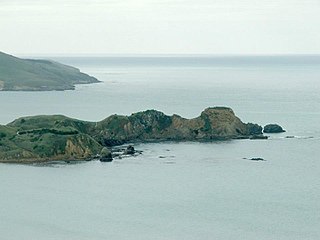
Huriawa, commonly known as Huriawa Peninsula or Karitane Peninsula, is a headland on the coast of Otago, New Zealand. It is located 35 kilometres north of Dunedin city centre, immediately to the southeast of the settlement of Karitane.
In February 2021, the East Otago towns of Waikouaiti and Karitane in New Zealand reported high lead levels in their water supplies. Local and national authorities responded by dispatching water tanks and staff to assist local residents and offering them free blood tests, fruits and vegetables. The lead poisoning scare also attracted covered by national media. By 10 March 2021, the Southern District Health Board confirmed that test results indicated that long term exposure to lead in the water supply posed minimial risk to the local population.
Hawksbury Lagoon is situated within the East Otago town of Waikouaiti, on the northern boundary of Dunedin City, New Zealand.
This page is based on this Wikipedia article Text is available under the CC BY-SA 4.0 license; additional terms may apply. Images, videos and audio are available under their respective licenses.