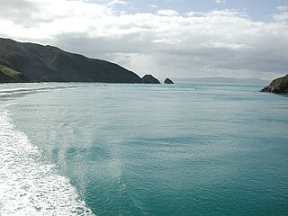
Tory Channel is one of the drowned valleys that form the Marlborough Sounds in New Zealand. Inter-island ferries normally use it as the principal channel between Cook Strait and the Marlborough Sounds.

Lake Wakatipu is an inland lake in the South Island of New Zealand. It is in the southwest corner of the Otago region, near its boundary with Southland. Lake Wakatipu comes from the original Māori name Whakatipu wai-māori.

The Maniototo Plain, usually simply known as The Maniototo, is an elevated inland region in Otago, New Zealand. The region roughly surrounds the upper reaches of the Taieri River and the Manuherikia River. It is bounded by the Kakanui Range to the north and the Rock and Pillar Range to the southeast. It has a harsh, dry climate, ranging from over 30 °C in mid-summer to -15 °C in mid-winter.
Mount Nimrod is a hill in the Hunters Hills area of Canterbury, New Zealand.

Ōtaki is a town in the Kāpiti Coast District of the North Island of New Zealand, situated halfway between the capital city Wellington, 70 km (43 mi) to the southwest, and Palmerston North, 70 km (43 mi) to the northeast.
The Rock and Pillar Range, is a range of high hills is located in the Maniototo, an area of inland Otago, New Zealand. The range is surrounded on three sides by the Taieri River, which has its source in the Lammerlaw Range. The river flows out across the scroll plain at Paerau, along the north west flanks of the Rock and Pillar Range before almost doubling back on itself at Waipiata and flowing back along the eastern side past Hyde through the Strath-Taieri. The town of Middlemarch lies close to the Taieri River to the east of the range, and Patearoa lies to the northwest.

The Ōrongorongo River runs for 32 kilometres (20 mi) southwest through the Ōrongorongo Valley in the southern Remutaka Ranges of the North Island of New Zealand. The river and its associated catchments lie within the bounds of the Remutaka Forest Park, which is administered by the Department of Conservation.
The Waipawa River is a braided river of southern Hawke's Bay, in New Zealand's eastern North Island. It flows southeast from the slopes of 1,687 m (5,535 ft) Te Atuaoparapara in the Ruahine Range, past the town of Waipawa, before joining the Tukituki River. The river rises at the 1,326 m (4,350 ft) Waipawa Saddle, which is also the source of the Waikamaka River. The Mangaonuku Stream is a tributary on the northern bank, west of Waipawa, near Ruataniwha. The Waipawa's flow is generally greater than that of the Tukituki River, into which it flows.
The New Zealand Geographic Board Ngā Pou Taunaha o Aotearoa (NZGB) is the authority over geographical and hydrographic names within New Zealand and its territorial waters. This includes the naming of small urban settlements, localities, mountains, lakes, rivers, waterfalls, harbours and natural features and may include researching local Māori names. It has named many geographical features in the Ross Sea region of Antarctica. It has no authority to alter street names or the name of any country.

French Pass is a narrow and treacherous stretch of water that separates D'Urville Island, at the north end of the South Island of New Zealand, from the mainland coast. At one end is Tasman Bay, and at the other end the outer Pelorus Sound / Te Hoiere leads out to Cook Strait.

Meretoto / Ship Cove is a small bay in the Marlborough Region of New Zealand, renowned as the first place of prolonged contact between Māori and Europeans. It is located near the entrance of Queen Charlotte Sound / Tōtaranui, west of nearby Motuara Island and Long Island.

The Manganuioteao River is a river of the centre of New Zealand's North Island. It has its source in numerous streams and small rivers which flow west from the slopes of Mount Ruapehu, though the main course of the river flows predominantly southwest through rugged hill country to meet with the Whanganui River 10 kilometres (6 mi) north of Pipiriki, at the edge of the Whanganui National Park.

The Opotoru River is a river of the Waikato Region of New Zealand's North Island. It flows north, reaching the Raglan Harbour southwest of the town of Raglan. There is no regular monitoring of pollution, but 38 kilometres (24 mi) (31.2%) of the river has been fenced to protect it from farm stock.

The Waiariki River is a river of the Northland Region of New Zealand's North Island. It forms at the confluence of the Waikiore and Pukekaikiore Streams and is in the catchment of the Wairua River, which it reaches by the Waiotu River, approximately halfway between Whangārei and Kawakawa.
Te Huruhuru was a notable New Zealand tribal leader. Of Māori descent, he identified with the Ngāi Tahu iwi.

Hapuakohe Range of hills is aligned north–south, between the Waikato River and the Hauraki Plains in the Waikato region of New Zealand. It is separated from the Taupiri Range by an air-gap at Mangawara, where the Waikato flowed about 20,000 years ago.

The Lammerlaw Range is in the Otago region of New Zealand. It is an important watershed, and the source of many of the tributaries in the Taieri and lower Clutha River systems. The origins of the placename are Scottish. Windfarms have been sited in the area. The area includes distinctive geology including ribbon fens and peat habitats. The Lammerlaw and adjacent to the northeast Lammermoor Ranges also include tussock grasslands. Parts of the ranges are in Te Papanui Conservation Park. The endangered Eldon's galaxias is found in the range.

Mount Alfred is a hill in Otago, New Zealand, that was formed by glaciers during the last ice age. It is the prominent hill due north from Glenorchy located between the Dart River / Te Awa Whakatipu and Rees River located in the Queenstown-Lakes District.
Hunters Hills is a range of mountains in South Canterbury, New Zealand.
