Princes Street, Dunedin

Last updated

Princes Street
Princes street 2023.jpg
From The Exchange, looking north up Princes Street towards The Octagon. The historic Southern Cross Hotel building is prominent, centre-left, the former BNZ bank building is centre-right.
Maintained byDunedin City Council
Length2.0 km (1.2 mi)
Location Dunedin, New Zealand
Postal code9016
North end Octagon, central Dunedin
South endKing Edward Street/Ardmore Drive, Kensington

Princes Street (often misspelt as "Princess Street" [1] [2] ) is a major street in Dunedin, the second largest city in the South Island of New Zealand. It runs south-southwest for two kilometres from The Octagon in the city centre to the Oval sports ground, close to the city's Southern Cemetery. North of The Octagon, George Street continues the line of Princes Street north-northeast for two and a half kilometres. Princes Street is straight but undulating, skirting the edge of the City Rise to its northwest. The part of the street immediately below The Octagon is the steepest section, as the road traverses an old cutting through Bell Hill.

Contents

Princes Street was developed during Dunedin's 1860s boom from the Central Otago gold rush, and consequently is one of New Zealand's most historic streets, with about 70 buildings in close proximity listed on the New Zealand Historic Places Trust Register. Originally the site of the city's wharf, a substantial area of land to the east of the street was formerly part of Otago Harbour, much of it reclaimed via rock removed during the lowering of Bell Hill which separated Princes Street from northern Dunedin in the early years of settlement. [3] In the years following the gold rush, Princes Street was the heart of Dunedin's central business district, but much of the city's main retail area has now shifted north to George Street.

History

In the early years of Dunedin's settlement, much of the city's growth was on two areas of reasonably flat land close to the harbour, separated by the large Bell Hill and an area of low swampy land. [3] The northern of these two flat areas surrounded the floodplain of the Water of Leith, a small river that runs through Dunedin. As the city grew the swamp was drained to become the new city's centre, and the hill was lowered by excavation to allow access between the two areas of settlement. A street grid was set up with the main road split in two by the city centre (now The Octagon) – Princes Street to the south and George Street to the north. As with many of the city's other place names, both these names and that of the Water of Leith reflect the names of places in Edinburgh, Scotland. [4]

In the settlement's early days, Bell Hill proved a major obstacle to travel south of the city centre, and major excavation work was carried out to provide access to the south. A cutting was made in the hill in 1858, and during the 1860s the hill was lowered by some 14 metres (46 ft). [5] The cutting allowed for the passage of transport between the two parts of the town. The southern flank of the hill was also completely removed (that area now being occupied by Queen's Gardens). The stone removed from the hill was used as construction material for many of the city's first permanent buildings, and also as fill to reclaim the northern end of the Southern Endowment along the edge of the harbour. [6] This reclamation work added a considerable area to the central city; the original docks, close to the Exchange area of Princes Street, are now several hundred metres inland.

The area of Princes Street between the Exchange and Market Reserve was a frequent source of dispute in the early years of European settlement. This area, at that time on the foreshore of Otago Harbour was a traditional landing site for Māori waka. Captain Cargill, the founder of the new city, wished to follow the British practice of keeping the foreshore as public land. As the town spread, the area around the landing site became populated by settlers, and visiting Maori relied on the coastal strip as a place to set up their encampments. The southern Commissioner for Crown Lands, Walter Mantell noted the problem and proposed to his superiors in Wellington that a site be found at which the Māori could erect permanent structures, naming the Princes Street foreshore as the preferred site. Mantell and Cargill, who had been bitter political opponents for the control of the early settlement, quickly found themselves at loggerheads over the proposal, and disputes over the ownership and allocation of the land dragged on for over two decades, finally being settled in the courts in 1877. [7] [8]

In the years following the Central Otago Gold Rush of the 1860s Dunedin grew rapidly, with much of the growth being centred on Princes Street. In the city's early years this road was notorious for its unformed rough nature, a consequence of the work on Bell Hill, and led to Dunedin's early nickname of "Mud-edin". [9] The prosperity brought by the gold rush led to a boom in construction, and within a handful of years, the area around lower Princes Street became the most prosperous in the country. Many of the prominent grand buildings of this part of Dunedin date from this period, and numerous structures in the area have New Zealand Historic Places Trust classification as a result.

There is a considerable photographic record of early Princes Street, largely thanks to the presence in the street of the studios of the Burton Brothers, pioneering New Zealand photographers. [10] Many of their images, and those of other early Dunedin photographers, were collated and published in a series of books by photographic historian Hardwicke Knight, one of which — a collection of photographic works by Daniel Louis Mundy — was entitled Princes Street by gaslight (1977). [11]

Several notable companies have either been founded or had their headquarters in Princes Street. Notable among these were The Drapery and General Importing Company of New Zealand, later simply known as The D.I.C., Hallenstein's, and H.E. Shacklock. The first New Zealand headquarters of Briscoes were also located on Princes Street.

In 2018, Whakamana Cannabis Museum, New Zealand's first and only cannabis museum, relocated to the Eldon Chambers Building on Princes Street, [12] though it has since moved to Christchurch.

Route

Central Dunedin. Princes Street (4) is the street shown in red leading south from the Octagon (2). The 4 is placed at the location of John Wickliffe Plaza. Dunedin central map.svg
Central Dunedin. Princes Street (4) is the street shown in red leading south from the Octagon (2). The 4 is placed at the location of John Wickliffe Plaza.

The "Top 100"

The Dowling Street steps Dunedin Stairs 002.JPG
The Dowling Street steps
Former National Bank building, 193 Princes Street Dunedin National Bank of New Zealand 002.JPG
Former National Bank building, 193 Princes Street

From the Octagon, Princes Street initially rises as it passes through a commercial district formerly commonly known as the Top 100, crossing the outer Octagon of Moray Place before descending through the original cutting of Bell Hill towards the Exchange. The Top 100 theoretically took its name from the 100 retail businesses which line Princes Street from the Octagon to the Exchange, although the actual number of businesses is not one hundred. This part of the city is sometimes seen as the creative heart of Dunedin, with numerous art galleries, artist's studios, and video production companies being based in the area from Moray Place to Rattray Street and especially around the Dowling Street area.

Some parts of the Bell Hill cutting are still visible from Princes Street, though the most obvious escarpment of the hill is found between Moray Place and Queen's Gardens, close to First Church. From Princes Street, the most notable part of the cutting is at Dowling Street, 300 metres south of the Octagon. Dowling Street narrows significantly above this intersection. The Dowling Street Steps, a 1926 structure listed by the New Zealand Historic Places Trust, rise from close to the Princes Street-Dowling Street intersection, ascending a cliff that was formed as a result of the original work on Bell Hill. [6] [13]

The Exchange

The Exchange Building, designed by William Mason and demolished in the 1960s to make way for John Wickliffe House, gave the area its name Dunedin Exchange Building.jpg
The Exchange Building, designed by William Mason and demolished in the 1960s to make way for John Wickliffe House, gave the area its name

The Exchange, 400 metres south of The Octagon and extending for one block on either side of Princes Street, was the original financial heart of the city, but the CBD has drifted north to its current location on George Street. Princes Street still contains many of the city's older and more stately business properties, particularly in the few blocks from The Exchange south. This area is also the lowest part of the street, as it descends from the remains of Bell Hill. Now several hundred metres inland from the edge of the Otago Harbour, this was the site of the original landing place of settlers from the two ships which brought the Otago Association's settlers to Dunedin, and was the site of the homes and offices of the city's founder, Captain William Cargill and chief surveyor Charles Kettle. [14] The two ships, the John Wickliffe and the Philip Laing, arrived in early 1848. As they could not negotiate the harbour, they set anchor at the Otago Heads. Settlers from the ships travelled by smaller rowing boat from there to Dunedin. [15] Massive reclamation of the area led to the creation of a wide strip of land, since occupied by commercial premises, warehousing, and the main rail line. The original nature of the site is reflected in the names of Jetty Street and Water Street, both of which cross Princes Street close to the Exchange. This part of Princes Street was at one point the location of a bridge across a small stream, the Toitu Stream, now diverted underground. [16] A spring which fed the stream is still used as the source of water for Speight's Brewery, which is located 200 metres to the northwest on Rattray Street. [17]

The Cargill Monument is a prominent feature of John Wickliffe Plaza. Behind it (to the right) is the historic former Bank of New Zealand Building. Cargill's Monument, Dunedin, NZ.JPG
The Cargill Monument is a prominent feature of John Wickliffe Plaza. Behind it (to the right) is the historic former Bank of New Zealand Building.

The former Exchange Building, from which The Exchange takes its name, was an impressive structure, designed by William Mason as a Post Office and later occupied by the University of Otago and the Otago Museum. Next to this was the 1863 Customhouse building, and outside the two was an open space known as Customhouse Square. [18] The Exchange building was pulled down in 1969, and it was largely the destruction of this building that led to changes in attitudes by Dunedinites regarding the change of their cityscape. Since this time, changes to the city's old buildings have been met with vociferous protests. The Customhouse building is also long since gone. Today, the site of the buildings is the location of one of Dunedin's biggest office blocks, John Wickliffe House, and the nearby John Wickliffe Plaza. Both are named for the John Wickliffe, the first of the two ships which brought the Otago Association's settlers to Dunedin (a nearby building, Philip Laing House, is named for the other of these two ships). Despite this, the area is the site of several prominent Victorian buildings, notably former bank buildings at the northern end of the area. Other imposing buildings in the area include the Chief Post Office building, the proposed site of a hotel, and – one block to the east – Consultancy House, a seven-storey 1908 building regarded (by dint of its construction methods) as Dunedin's first skyscraper. [19] John Wickliffe Plaza is also the site of one of Dunedin's more notable public monuments, the Cargill Monument, dedicated to city founder Captain William Cargill. This monument, designed by Charles Robert Swyer and built in 1863-4, was originally sited in the Octagon, but was moved to the Exchange in 1872. [20]

The Exchange was at one time a complex intersection with two busy streets, Rattray Street and High Street. These lead from the twin streets which make up State Highway 1 at Queen's Gardens (an open park containing the city's main war memorial, Dunedin Cenotaph, close to which lies the Toitū Otago Settlers Museum and the Dunedin Chinese Garden) 200 metres to the east of Princes Street, to the older hill suburbs to the west. Though these streets originally both crossed Princes Street, civic planning has reduced High Street at the intersection to a minor road, and John Wickliffe Plaza now covers part of the original intersection. The area around State Highway 1, extending from the Exchange and Queen's Gardens south towards the Oval, is known as the Warehouse Precinct, and is the site of several major street beautification projects.

Apart from the Cargill Monument, the Plaza contains several other items of public sculpture, notably a series of three small brass penguins called "We are not alone", sculpted by Dan Parry-Jones and unveiled in 1999. [21] A Historic Places Trust blue plaque at the foot of the Cargill Monument marks the location of the first Salvation Army meeting in New Zealand, held at the site in April 1883. [20]

Below the Exchange

Wain's Hotel building, in the Exchange WainsHotelDunedin.jpg
Wain's Hotel building, in the Exchange

The lower Exchange and area immediately to the south of it contains some other notable buildings, including several of Dunedin's more notable former and current public houses. Among these are Wain's Hotel, the Provincial Hotel (at the foot of Stafford Street), the Empire Tavern, and the former Prince of Wales Hotel. Wain's Hotel, immediately opposite the former Post Office building, is an imposing Italianate structure built in 1878 from designs by Mason and Wales. [22] The Empire Tavern also has a long history, and claims to be Dunedin's oldest pub, having been continuously licensed since 1858. Its recent past is closely tied with the Dunedin sound music scene of the 1980s, of which it was a principal venue. [23] Prior to its gutting by fire in the 1980s, the Prince of Wales Hotel, a block further down Princes Street, was noted for an unusual gimmick, in that the upstairs restaurant facilities were extensively themed on old railway carriages, and included in their decor several original vintage pieces of rolling stock. The Prince of Wales was later (1992–2010) the location of one of the city's top restaurants, Bell Pepper Blues. [24]

Lower Princes Street rises slightly from the Exchange before dropping down, becoming flat for the final kilometre of its length. Here, there is a mix of commercial, wholesale, and light industrial properties, with only occasional retail shops. The street itself widens from thee crest below the Exchange, becoming a dual carriageway from this point south to the major junction at the southern end of the Oval. Several notable buildings are still found in the lower Princes Street area, among them the former H.E. Shacklock building and the Crown Roller Mills Building; the latter in particular is a notable landmark. [25]

The Crown Roller Mills building is not in Princes Street itself, but rather lies at the foot of Manor Place, close to its intersection with Princes Street. It stands at the edge of a small area of parkland called the Market Reserve, at the opposite edge of which is the city's main bus depot. This area was swampland when the first European settlers arrived in Dunedin, but was reclaimed and did host a regular market for a few years from the 1870s. The market was not well-supported, however, and eventually folded. The bus depot is located on the site of the city's 1902 Tram workshops. [26] The Market Reserve also contains a children's playground and, at the edge closes to the Crown Roller Mills Building, a small monument dedicated to Otago workers who have lost their lives while at work. This simple bluestone memorial was erected in 2003 by the New Zealand Council of Trade Unions on a site donated by the Dunedin City Council. [27]

Kensington Oval lies at the southern end of Princes Street, effectively separating the central city from South Dunedin. KensingtonOvalDunedin.jpg
Kensington Oval lies at the southern end of Princes Street, effectively separating the central city from South Dunedin.

At the bottom end of Princes Street is the former Dunedin Metropolitan Club building, now home to Natural History New Zealand, one of the country's leading television production companies. Opposite this lies a large recreation reserve, which — despite its roughly triangular shape — is called the Oval, or more correctly, Kensington Oval. Kensington Oval contains mainly cricket and association football pitches, and also caters for rugby, hockey, and softball. [28] The Oval also contains one of the city's main war memorials, dedicated to the fallen of the Boer War campaign. This lies close to the Oval's northernmost point. Close to the Oval are two major road junctions. At the north end, a link road connects Princes Street with the city's one-way street system (part of State Highway 1) and with Anderson's Bay Road, a major arterial route to South Dunedin and Otago Peninsula. The part of Princes Street close to the Oval, as well as several other nearby streets, was for many years used annually as part of the Dunedin Street Circuit, a temporary inner city motor-racing circuit used during the week-long Southern Festival of Speed, which ran from the 1980s until the early 2010s. [29]

At the southern end of the Oval is a further junction, with Princes Street terminating in a link road to South Dunedin's main street, King Edward Street, and a further road skirting the edge of a hilly spur to join South Road at the northern end of the suburb of Caversham. This latter road passes Dunedin's Southern Cemetery, the oldest and arguably most historic of the city's main cemeteries. The Southern Cemetery's earliest graves are from 1858, and it contains the remains of many of the city's founding fathers, including Captain William Cargill, Thomas Burns, and Johnny Jones. [30] The cemetery is notable for its large Chinese and Jewish sections. [31] [32]

The top section of Princes Street, from the Octagon to the Exchange, has for many years been a nexus for Dunedin's public transport system. Until the 2010s, buses from the north of the city largely passed along George Street and into the Octagon; since that time they have largely avoided George Street, being routed through a new bus hub in Great King Street. Buses from the south pass into the southern end of Princes Street, and those from the hill suburbs arrive at the Octagon via Stuart Street or at the Exchange via High and Rattray Streets. Almost all of these use upper Princes Street between the Exchange and the Octagon as part of their route. [33]

In the city's early years trams followed many of these same routes. Until the demise of the system in the 1950s, this area was also at the heart of the Dunedin cable tramway system, with the longer lines running up the slopes of City Rise via High, Rattray, or Stuart Streets. [34] [35]

Heritage New Zealand listed buildings

The Haynes' (Savoy) Building at the corner of Princes Street and Moray Place SavoyHaynesDunedin.jpg
The Haynes' (Savoy) Building at the corner of Princes Street and Moray Place

Few, if any, streets in New Zealand contain as many Heritage New Zealand Category I or Category II protected buildings as Princes Street. These buildings include the following:

NZHPT Blue Plaque at the Queen's Building, site of the first public performance of the New Zealand national anthem. God Defend New Zealand blue plaque.jpg
NZHPT Blue Plaque at the Queen's Building, site of the first public performance of the New Zealand national anthem.
The historic H. E. Shacklock buildings in lower Princes Street Shacklock buildings, Dunedin, NZ.jpg
The historic H. E. Shacklock buildings in lower Princes Street

The Cargill Monument at John Wickliffe Plaza is also listed (Category I), as are numerous buildings and structures which lie close to the intersection of side roads with Princes Street (e.g., the Category I Crown Roller Mills Building in Manor Place and the Category II Dowling Street Steps). [39]

See also

Notes

  1. "Vintage postcard of "Princess Street, Dunedin", O Neherā, University of Waikato. Retrieved 26 January 2023.
  2. Vintage postcard of "Princess St, Dunedin, NZ" mediastorehouse.com. Retrieved 26 January 2023.
  3. 1 2 Smith, C., "The anatomy of a city," Otago Daily Times, 26 November 2009. Retrieved 26 January 2023.
  4. "Dunedin's Scottish heritage", Dunedin City Council website. Retrieved 5 November 2010.
  5. Herd & Griffiths 1980, pp. 30–31.
  6. 1 2 Reed 1956, pp. 68, 113.
  7. Goodall & Griffiths 1980, pp. 20–27.
  8. Sorrenson, M. P. K. "Mantell, Walter Baldock Durrant". Dictionary of New Zealand Biography . Ministry for Culture and Heritage . Retrieved 13 April 2014.
  9. Reed 1975, pp. 108–109.
  10. Knight, Hardwicke. "Burton, Alfred Henry". Dictionary of New Zealand Biography . Ministry for Culture and Heritage . Retrieved 13 April 2014.
  11. Details of this book at OpenLibrary.com
  12. "Dunedin's Cannabis Museum left high and dry over alleged fake landlord". Stuff. 12 May 2018.
  13. Herd & Griffiths 1980, p. 48.
  14. Miller, T., and Brosnahan, S., "170 years of change: Dunedin's original shoreline," Otago Daily Times, 9 April 2020. Accessed 25 January 2023.
  15. Reed 1956, pp. 33ff.
  16. Reed 1956, pp. 162–164.
  17. "Speight's water tap," www.dunedinnz.com. Accessed 25 January 2023.
  18. Johnson 1993, p. 113.
  19. "Experience Architectural Heritage" (PDF). DunedinNZ.com. p. 6. Archived from the original (PDF) on 16 October 2008. Retrieved 26 December 2008.
  20. 1 2 Herd & Griffiths 1980, p. 40.
  21. Otago Sculpture Trust 2005, p. 9.
  22. 1 2 Knight & Wales 1988, pp. 185f.
  23. Bannister 1999, p. 45.
  24. Price, Mark (15 January 2010). "September swan song for Bell Pepper Blues". Otago Daily Times . Retrieved 12 April 2014.
  25. "Heritage Preserved", trendsideas.com. Retrieved 3 November 2010
  26. Hayward 1999, p. 40.
  27. Otago Sculpture Trust 2005, p. 19.
  28. Dunedin City Council guide to the Kensington Oval.
  29. "High speeds on Princes St". Otago Daily Times. 7 December 2009. Retrieved 23 January 2023.
  30. Herd & Griffiths 1980, pp. 112f.
  31. Morris, Chris (15 April 2009). "Trust impressed by restoration of Chinese graves". Otago Daily Times . Retrieved 4 November 2011.
  32. Archived 10 October 2010 at the Wayback Machine
  33. Dunedin bus route map, Otago Regional Council. Accessed 23 January 2023.
  34. Rice, W. "When the endless wire rope stopped in Dunedin, New Zealand, San Francisco was left alone", www.cablecarmuseum.org. Retrieved 5 November 2010.
  35. Hunt, D. (10 March 2010)"Reliving the past in words and paintings – Don McAra's 'Hold Very tight Please! – The Cable Cars of New Zealand'", nzine.co.nz. Retrieved 5 November 2010.
  36. Parker Warburton Team Architects 2010, p. 11.
  37. Parker Warburton Team Architects 2010, p. 12.
  38. Parker Warburton Team Architects 2010, p. 13.
  39. 1 2 3 "Heritage New Zealand". www.heritage.org.nz.
  40. Knight & Wales 1988, pp. 77–79.
  41. 1 2 3 Parker Warburton Team Architects 2010, p. 14.
  42. "Chief Post Office". New Zealand Heritage List/Rārangi Kōrero. Heritage New Zealand.
  43. Hotel website. Accessed 23 January 2023.
  44. 1 2 Parker Warburton Team Architects 2010, p. 15.

Related Research Articles

<span class="mw-page-title-main">Dunedin</span> City in Otago, New Zealand

Dunedin is the second-largest city in the South Island of New Zealand, and the principal city of the Otago region. Its name comes from Dùn Èideann, the Scottish Gaelic name for Edinburgh, the capital of Scotland. The city has a rich Māori, Scottish, and Chinese heritage.

Dunedin is a city of 134,600 people in the South Island of New Zealand. The principal suburbs of Dunedin are as follows. Inner and outer suburbs are ordered by location, clockwise from the city centre, starting due north:

<i>John Wickliffe</i> (ship) 19th-century Scottish ship

John Wickliffe was the first ship to arrive carrying Scottish settlers, including Otago settlement founder Captain William Cargill, in the city of Dunedin, New Zealand. The ship was named after a religious reformer, John Wycliffe.

<span class="mw-page-title-main">George Street, Dunedin</span>

George Street is the main street of Dunedin, the second largest city in the South Island of New Zealand. It runs for two and a half kilometres north-northeast from The Octagon in the city centre to the foot of Pine Hill. It is straight and undulates gently as it skirts the edge of the hills to its northwest. South of The Octagon, Princes Street continues the line of George Street south-southwest for two kilometres.

<span class="mw-page-title-main">First Church of Otago</span>

First Church is a prominent church in the New Zealand city of Dunedin. It is located in the heart of the city on Moray Place, 100 metres to the south of the city centre. The church is the city's primary Presbyterian church. The building is regarded as the most impressive of New Zealand's nineteenth-century churches, and is listed by Heritage New Zealand as a Category I structure.

<span class="mw-page-title-main">The Octagon, Dunedin</span> City centre of Dunedin

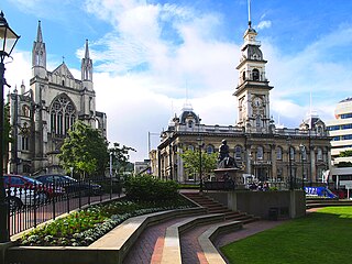
The Octagon is the city centre of Dunedin, in the South Island of New Zealand. It is an eight-sided plaza with a circular one-way carriageway, bisected by the city's main street, and is also the central terminus of two other main thoroughfares. The Octagon is predominantly a pedestrian reserve, with grass and paved features, and is surmounted by a statue of the Scottish poet Robert Burns. Several of Dunedin's significant buildings and institutions adjoin the plaza, which is also a major hub for public transport in Dunedin, primarily taxi services.

<span class="mw-page-title-main">Moray Place, Dunedin</span> Street in Dunedin, Otago Region, New Zealand

Moray Place is an octagonal street which surrounds the city centre of Dunedin, Otago, New Zealand. The street is intersected by Stuart Street, Princes Street and George Street. Like many streets in Dunedin, it is named for a street in the Scottish capital Edinburgh.

<span class="mw-page-title-main">History of the Dunedin urban area</span> Aspect of history of city of Dunedin, New Zealand

The villages and then city that lay at the head of Otago Harbor never existed in isolation, but have always been a staging ground between inland Otago and the wider world. While Dunedin's current official city limits extend north to Waikouaiti, inland to Middlemarch and south to the Taieri River mouth, this articles focus is the history of the Dunedin urban area, only mentioning Mosgiel, the Otago Peninsula, Port Chalmers and inland Otago for context.

<span class="mw-page-title-main">Stuart Street, Dunedin</span> Street in Dunedin, New Zealand

Stuart Street is one of the main streets of Dunedin, New Zealand. As with many of Dunedin's streets, it is named after a main street in Edinburgh, Scotland.

<span class="mw-page-title-main">St Clair, New Zealand</span> Suburb in Dunedin, New Zealand

St Clair is a leafy residential suburb of Dunedin, New Zealand. It is located on the Pacific Ocean coast five kilometres from the city centre on the southwesternmost part of the coastal plain which makes up the southern part of the urban area, and also climbs the slopes of Forbury Hill immediately to the west of this plain. St Clair's 2001 population was 4,179.

<span class="mw-page-title-main">Caversham, New Zealand</span> Suburb in Dunedin, New Zealand

Caversham is one of the older suburbs of the city of Dunedin, in New Zealand's South Island. It is sited at the western edge of the city's central plain at the mouth of the steep Caversham Valley, which rises to the saddle of Lookout Point. Major road and rail routes south lie nearby; the South Island Main Trunk railway runs through the suburb, and a bypass skirts its main retail area, connecting Dunedin's one-way street system with the Dunedin Southern Motorway. The suburb is linked by several bus routes to its neighbouring suburbs and central Dunedin.

<span class="mw-page-title-main">City Rise</span> Suburb of Dunedin, New Zealand

City Rise is an inner suburb of the New Zealand city of Dunedin. One of the city's older suburbs, it is, as its name suggests, centred on the slopes which lie close to the city centre, particularly those closest to the city's original heart of The Exchange. Extensive views across the central city can be gained from much of City Rise.

<span class="mw-page-title-main">South Dunedin</span> Suburb of Dunedin, New Zealand

South Dunedin is a major inner city suburb of the New Zealand city of Dunedin. It is located, as its name suggests, 2.5 kilometres (1.6 mi) to the south of the city centre, on part of a large plain known locally simply as "The Flat". The suburb is a mix of industrial, retail, and predominantly lower-quality residential properties.

<span class="mw-page-title-main">Kensington, Dunedin</span>

Kensington is a small suburb of the New Zealand city of Dunedin, nestled to the south of a hilly spur between the central city and the major suburb of South Dunedin, some 2.4 kilometres (1.5 mi) to the south of the city centre. The suburb was named for the leafy London suburb, possibly by John Hyde Harris, who subdivided the area in the 1860s.

<span class="mw-page-title-main">Dunedin Southern Cemetery</span> Cemetery in Otago, New Zealand

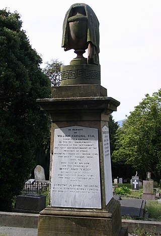
The Southern Cemetery in the New Zealand city of Dunedin was the first major cemetery to be opened in the city. The cemetery was opened in 1858, ten years after the founding of the city in an area known as Little Paisley. This area lies at the southern end of Princes Street, one of the city's main streets, close to the suburbs of Kensington, Maryhill, and The Glen.

<span class="mw-page-title-main">Warehouse Precinct</span> Dunedin suburb

The Warehouse Precinct is an urban area of the New Zealand city of Dunedin. Sited on reclaimed land at the northernmost tip of the Southern Endowment, it lies between 1 and 2 kilometres south of The Octagon, the city's centre.

<span class="mw-page-title-main">Queens Gardens, Dunedin</span>

Queens Gardens is a roughly triangular area of trees and lawn in central Dunedin, New Zealand.

<span class="mw-page-title-main">Cargill Monument</span> Monument in Dunedin, New Zealand

The Cargill Monument is a notable public monument in central Dunedin, New Zealand. It is dedicated to the city's founding father, Captain William Cargill, and is approximately 7.5 metres (25 ft) in height.

<span class="mw-page-title-main">Central Dunedin</span> Suburb in Dunedin, New Zealand

Central Dunedin is the central suburb and business district of the New Zealand city of Dunedin.

References

45°52′49″S170°30′01″E / 45.8802°S 170.5003°E / -45.8802; 170.5003