East Taieri

Last updated

East Taieri
Settlement
East Taieri Presbyterian Church.jpg
East Taieri Presbyterian Church
East Taieri
Coordinates: 45°53′55″S170°20′0″E / 45.89861°S 170.33333°E / -45.89861; 170.33333
CountryNew Zealand
Island South Island
Region Otago
District Dunedin
Community board Mosgiel-Taieri Community Board [1]
Electorates
Government
   Territorial authority Dunedin City Council
  Regional council Otago Regional Council
   Mayor of Dunedin Jules Radich
   Taieri MP Ingrid Leary
   Te Tai Tonga MP Tākuta Ferris
Area
[2]
  Total3.13 km2 (1.21 sq mi)
Population
 (June 2023) [3]
  Total2,460
  Density790/km2 (2,000/sq mi)
Time zone UTC+12 (NZST)
  Summer (DST) UTC+13 (NZDT)
Area code03
Local iwi Ngāi Tahu

East Taieri is a small township, located between Mosgiel and Allanton in New Zealand's Otago region. It lies on State Highway 1 en route between the city of Dunedin and its airport at Momona. It lies close to the southeastern edge of the Taieri Plain, hence its name. [4]

Contents

Demographics

East Taieri covers 3.13 km2 (1.21 sq mi) [2] and had an estimated population of 2,460 as of June 2023, [3] with a population density of 786 people per km2.

Historical population
YearPop.±% p.a.
20061,653    
20131,935+2.28%
20182,181+2.42%
Source: [5]

East Taieri had a population of 2,181 at the 2018 New Zealand census, an increase of 246 people (12.7%) since the 2013 census, and an increase of 528 people (31.9%) since the 2006 census. There were 786 households, comprising 1,107 males and 1,074 females, giving a sex ratio of 1.03 males per female. The median age was 44.8 years (compared with 37.4 years nationally), with 426 people (19.5%) aged under 15 years, 312 (14.3%) aged 15 to 29, 1,089 (49.9%) aged 30 to 64, and 354 (16.2%) aged 65 or older.

Ethnicities were 94.4% European/Pākehā, 6.6% Māori, 1.2% Pasifika, 3.0% Asian, and 1.5% other ethnicities. People may identify with more than one ethnicity.

The percentage of people born overseas was 12.0, compared with 27.1% nationally.

Although some people chose not to answer the census's question about religious affiliation, 53.0% had no religion, 39.6% were Christian, 0.7% were Hindu, 0.4% were Muslim, 0.3% were Buddhist and 1.1% had other religions.

Of those at least 15 years old, 384 (21.9%) people had a bachelor's or higher degree, and 303 (17.3%) people had no formal qualifications. The median income was $43,200, compared with $31,800 nationally. 456 people (26.0%) earned over $70,000 compared to 17.2% nationally. The employment status of those at least 15 was that 993 (56.6%) people were employed full-time, 267 (15.2%) were part-time, and 48 (2.7%) were unemployed. [5]

Notable buildings

The East Taieri Presbyterian Church was designed by Robert Lawson and opened in 1870, replacing an earlier building which had served as both church and school. The church was extended with an administration and fellowship centre in the 1990s. [6]

The Presbyterian Manse was designed by N.Y.A. Wales and built in 1877–78. It was renovated in the late 1970s and again in 2001, and has been the home of the ministers of East Taieri Presbyterian Church. [7]

Education

East Taieri School East Taieri School.jpg
East Taieri School

East Taieri School is a state contributing primary school catering for years 1 to 6. [8] It had a roll of 298 as of February 2024. [9] The school was founded as a preaching station in 1853 and moved to its current location in 1863. [10]

Related Research Articles

<span class="mw-page-title-main">Otago</span> Region of New Zealand

Otago is a region of New Zealand located in the southern half of the South Island administered by the Otago Regional Council. It has an area of approximately 32,000 square kilometres (12,000 sq mi), making it the country's second largest local government region. Its population was 254,600 in June 2023.

<span class="mw-page-title-main">Waikouaiti</span> Town in Otago, New Zealand

Waikouaiti is a small town in East Otago, New Zealand, within the city limits of Dunedin. The town is close to the coast and the mouth of the Waikouaiti River.

<span class="mw-page-title-main">Dunedin</span> City in Otago, New Zealand

Dunedin is the second-largest city in the South Island of New Zealand, and the principal city of the Otago region. Its name comes from Dùn Èideann, the Scottish Gaelic name for Edinburgh, the capital of Scotland. The city has a rich Māori, Scottish, and Chinese heritage.

<span class="mw-page-title-main">Mosgiel</span> Town in Otago, New Zealand

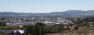
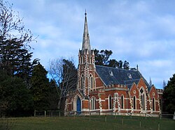
Mosgiel is an urban satellite of Dunedin in Otago, New Zealand, fifteen kilometres west of the city's centre. Since the re-organisation of New Zealand local government in 1989 it has been inside the Dunedin City Council area. Mosgiel has a population of approximately 14,800 as of June 2023. A nickname for Mosgiel is "The pearl of the plain". Its low-lying nature does pose problems, making it prone to flooding after heavy rains. Mosgiel takes its name from Mossgiel Farm, Ayrshire, the farm of the poet Robert Burns, the uncle of the co-founder in 1848 of the Otago settlement, the Reverend Thomas Burns.

<span class="mw-page-title-main">Taieri Mouth</span> Rural settlement in Otago, New Zealand

Taieri Mouth is a small fishing village at the mouth of the Taieri River, New Zealand. Taieri Island (Moturata) lies in the ocean several hundred metres off the river's mouth.

<span class="mw-page-title-main">Strath Taieri</span> Geographic region in New Zealand

The Strath Taieri is a large glacial valley and river plateau in New Zealand's South Island. It is surrounded by the rugged hill ranges to the north and west of Otago Harbour. Since 1989 it has been part of the city of Dunedin. The small town of Middlemarch is located at its southern end.

<span class="mw-page-title-main">Outram, New Zealand</span> Town in the South Island of New Zealand

Outram is a rural suburb of Dunedin, New Zealand, with a population of 880 as of June 2023. It is located 28 kilometres west of the central city at the edge of the Taieri Plains, close to the foot of Maungatua. The Taieri River flows close to the southeast of the town. Outram lies on State Highway 87 between Mosgiel and Middlemarch.

Allanton is a small town in Otago, New Zealand, located some 20 kilometres southwest of Dunedin on State Highway 1. The settlement lies at the eastern edge of the Taieri Plains close to the Taieri River at the junction of the main road to Dunedin International Airport at Momona.

<span class="mw-page-title-main">Stuart Street, Dunedin</span> Street in Dunedin, New Zealand

Stuart Street is one of the main streets of Dunedin, New Zealand. As with many of Dunedin's streets, it is named after a main street in Edinburgh, Scotland.

<span class="mw-page-title-main">Caversham, New Zealand</span> Suburb in Dunedin, New Zealand

Caversham is one of the older suburbs (neighbourhoods) of the city of Dunedin, in New Zealand's South Island. It is sited at the western edge of the city's central plain at the mouth of the steep Caversham Valley, which rises to the saddle of Lookout Point. Major road and rail routes south lie nearby; the South Island Main Trunk railway runs through the suburb, and a bypass skirts its main retail area, connecting Dunedin's one-way street system with the Dunedin Southern Motorway. The suburb is linked by several bus routes to its neighbouring suburbs and central Dunedin.

<span class="mw-page-title-main">Broad Bay, New Zealand</span> Settlement in New Zealand

The settlement of Broad Bay is located on the Otago Harbour coast of Otago Peninsula, in the South Island of New Zealand. It is administered as part of the city of Dunedin, and is technically a suburb of that city, though its isolation and semi-rural nature make it appear as a settlement in its own right.

Wakari is a residential suburb of the New Zealand city of Dunedin. It is located 2.5 kilometres (1.6 mi) to the northwest of the city centre, immediately to the west of the ridge which runs to the west of the city's centre. Wakari lies to the north of the upper reaches of the Kaikorai Valley, and is also north of the suburb of Kaikorai. The suburbs of Roslyn and Maori Hill are situated on the ridge immediately to the southeast and east of Wakari. The suburb of Halfway Bush lies to the northwest, and the smaller suburb of Helensburgh lies to the north.

<span class="mw-page-title-main">South Dunedin</span> Suburb of Dunedin, New Zealand

South Dunedin is a major inner city suburb of the New Zealand city of Dunedin. It is located, as its name suggests, 2.5 kilometres (1.6 mi) to the south of the city centre, on part of a large plain known locally simply as "The Flat". The suburb is a mix of industrial, retail, and predominantly lower-quality residential properties.

<span class="mw-page-title-main">Wingatui</span> Settlement in New Zealand

Wingatui is a small settlement almost 15 kilometres west of Dunedin, and two kilometres east of Mosgiel. It has become a suburb of Mosgiel, but continues to maintain its own unique identity and heritage.

<span class="mw-page-title-main">Symonds Street</span> Street in Auckland, New Zealand

Symonds Street is a street in Auckland, New Zealand's most populous city. The road runs southwest and uphill from the top of Anzac Avenue, through the City Campus of University of Auckland, over the Northwestern Motorway and Auckland Southern Motorway and to the start of New North Road and Mount Eden Road.

<span class="mw-page-title-main">Mosgiel Woollen Mill</span>

The Mosgiel Woollen Mill is situated in Mosgiel, Dunedin, New Zealand, and was opened in 1871.

<span class="mw-page-title-main">Appleby, New Zealand</span> Locality in Tasman District, New Zealand

Appleby is a locality in the Tasman district in the South Island of New Zealand. It is located around the Waimea River near the Tasman Bay / Te Tai-o-Aorere. It was first settled in the early 1840s. State Highway 60 passes through the settlement.

<span class="mw-page-title-main">Whare Flat</span> Locality in Otago Region, New Zealand

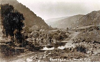
Whare Flat is a locality some 15 km to the northwest of Dunedin city centre, in the South Island of New Zealand. It is located at a widening of the Silver Stream's valley amid the foothills of the Silverpeaks.

Harbourside is a reclaimed area of land at the head of Otago Harbour in Dunedin, New Zealand. It is separated from the Dunedin central business district by the Main South Line. Most of the land was reclaimed in the 19th century. It is a port and industrial/warehousing area.

References

  1. "2016 Mosgiel-Taieri Community Board Boundary" (PDF). dunedin.govt.nz. Dunedin City Council . Retrieved 2 June 2022.
  2. 1 2 "ArcGIS Web Application". statsnz.maps.arcgis.com. Retrieved 8 January 2024.
  3. 1 2 "Population estimate tables - NZ.Stat". Statistics New Zealand . Retrieved 25 October 2023.
  4. Harriss, Gavin (November 2021). East Taieri, Otago (Map). NZ Topo Map.
  5. 1 2 "Statistical area 1 dataset for 2018 Census". Statistics New Zealand. March 2020. East Taieri (350300). 2018 Census place summary: East Taieri
  6. "East Taieri Presbyterian Church". New Zealand Heritage List/Rārangi Kōrero. Heritage New Zealand . Retrieved 31 December 2021.
  7. "Presbyterian Manse". New Zealand Heritage List/Rārangi Kōrero. Heritage New Zealand . Retrieved 31 December 2021.
  8. Education Counts: East Taieri School
  9. "New Zealand Schools Directory". New Zealand Ministry of Education. Retrieved 14 March 2024.
  10. "About Us and History". East Taieri School. Retrieved 30 December 2021.