Related Research Articles

Dunedin is the second-largest city in the South Island of New Zealand, and the principal city of the Otago region. Its name comes from Dùn Èideann, the Scottish Gaelic name for Edinburgh, the capital of Scotland. The city has a rich Māori, Scottish, and Chinese heritage.
East Otago is the name given to that part of Otago, in the South Island of New Zealand that lies directly to the north of Dunedin. To the south, its limit is approximately the rough hill pass of the Kilmog, 25 kilometres north of Dunedin city centre, and in the north the limit is the Shag River.

The small town of Karitane is located within the limits of the city of Dunedin in New Zealand, 35 kilometres to the north of the city centre.

The Silverpeaks is an area of rough forest and tussock and scrub covered hill country inland and to the northwest of Dunedin, New Zealand. The area is largely uninhabited; the main indication of human activity is the Taieri Gorge Railway, which preserves the route of the former Otago Central Railway that runs along the steep-sided valley of the Taieri River. Much of the area lies within the Silverpeaks Scenic Reserve.
Waitati, from the Māori Waitete, is a small seaside settlement in Otago, New Zealand, within the city limits of Dunedin. It is located close to the tidal mudflats of Blueskin Bay, 19 kilometres north of the Dunedin city centre. The small Waitati River flows through the bay to the sea.
Warrington, known in Māori as Ōkāhau, is a small settlement on the coast of Otago, in the South Island of New Zealand. It is situated close to the northern shore of Blueskin Bay, an area of mudflats north of Dunedin, and is administered as part of Dunedin City. Warrington is 3 km (1.9 mi) from State Highway 1 linked by Coast Road. The Main South Line railway passes through the township and a tourist train, the Seasider passes through the settlement once or twice a week between Dunedin and Palmerston.
Long Beach, known in Māori as Wharauwerawera or Wharewerawera is a small coastal settlement in Otago, New Zealand comprising approximately 100 homes. Many of the sections were initially auctioned in October 1922 for a pound deposit. It is located within the city limits of Dunedin, and lies 15 kilometres northeast of the city centre, between Blueskin Bay and the mouth of the Otago Harbour. The small settlement of Pūrākaunui is located nearby.

Blueskin Bay is an estuary in coastal Otago, about 25 km north of Dunedin, New Zealand. The name also unofficially describes the rural district which includes the northern slopes of Mount Cargill, the southern slopes of the Kilmog, and the townships of Doctors Point, Waitati, Evansdale, Warrington, and Seacliff.
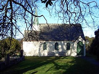
Seacliff is a small village located north of Dunedin in the Otago region of New Zealand's South Island. The village lies roughly halfway between the estuary of Blueskin Bay and the mouth of the Waikouaiti River at Karitane, on the eastern slopes of Kilmog hill. Coast Road, an old route north from Dunedin, and the South Island Main Trunk Railway pass through the village.

Orokonui Ecosanctuary, called Te Korowai o Mihiwaka in Māori, is an ecological island wildlife reserve developed by the Otago Natural History Trust in the Orokonui Valley between Waitati and Pūrākaunui, New Zealand, 20 kilometres (12 mi) to the north of central Dunedin.
Careys Creek, known in Māori as Whaitiripaku and Waihema, is a small river in Otago, New Zealand, which flows from the Silverpeaks into Blueskin Bay at Evansdale. The creek drains the forest plantations and native bush of Silverpeaks Forest and the Careys Creek Conservation Area. It is crossed by State Highway 1 at Evansdale, close to the foot of The Kilmog.
Hawksbury, also known as Cherry Farm, is a small residential and industrial area in New Zealand, located beside State Highway 1 between Dunedin and Waikouaiti.
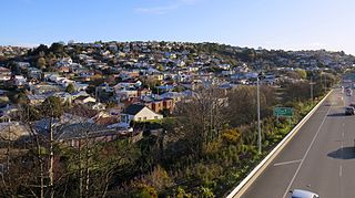
Evansdale is a census-gathering district in rural Dunedin, New Zealand. It encompasses all areas outside of urban areas between Mount Cargill and the northern Dunedin City boundary. It is named after one of the small villages it contains: Evansdale, New Zealand.
Calton Hill is an elevated southern residential suburb of the City of Dunedin in New Zealand's South Island. The suburb is named after Calton Hill in Edinburgh, Scotland, and some of its street names carry similar etymological roots.

Leith Saddle is a saddle between the sources of the Water of Leith and the Waitati River, approximately halfway between Dunedin's northern suburb of Pine Hill and the outlying settlement of Waitati. The saddle is a strategic point where the Dunedin Northern Motorway, part of State Highway 1 traverses a fragile alpine forest. Proposed road works to straighten a dangerous corner here conflict with conservation values. Water supply pipelines, and popular tramping and cycling routes also converge at the saddle.

Dunedin–Waitati Highway, formerly called Dunedin Northern Motorway, is a two-to-four-lane limited-access road which provides the main route north from the city of Dunedin, New Zealand. Opened on 14 December 1957, it superseded the narrow and winding routes via Port Chalmers and Mount Cargill. The road is occasionally briefly closed by snowfall in winter.

Papanui Inlet is the northernmost of two large inlets in the Pacific coast of Otago Peninsula, in the South Island of New Zealand.
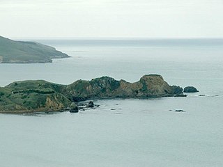
Huriawa, commonly known as Huriawa Peninsula or Karitane Peninsula, is a headland on the coast of Otago, New Zealand. It is located 35 kilometres north of Dunedin city centre, immediately to the southeast of the settlement of Karitane.
Whareakeake is a beach 25 kilometres (16 mi) northeast of Dunedin in the South Island of New Zealand, as well as the valley above and behind the beach. Located to the west of Aramoana and included as a section of the Otago Heads, Whareakeake was a place of habitation for Māori people from early times until the Sealers' War skirmish of 1817 from which it derived its colonial name. It is now a surfing beach renowned for its right-hand point break.

Ria Tikini or Ria Te Kini, also known as Mrs Chicken, was a New Zealand businesswoman, cultural informant and midwife. She is credited as one of the midwives who paved the way for the creation of the Plunket Society. As a Kāi Tahu and Kāti Mamoe woman, she was an informant for ethnographer William Anderson Taylor's work on Kāi Tahu history and early European contact with Māori.
References
- ↑ Place names Archived 2012-04-26 at the Wayback Machine on Kāti Huirapa Runaka ki Puketeraki website, viewed 2012-01-04
- ↑
- Bishop, D.G. and Turnbull, I.M. (1996). Geology of the Dunedin area. Lower Hutt: Institute of Geological and Nuclear Sciences. ISBN 0-478-09521-X.
- ↑ Moore, C.W.S. (1958) Northern approaches. Christchurch: Whitcombe & Tombs.
- ↑ Goodall, M., & Griffiths, G. (1980) Maori Dunedin. Dunedin: Otago Heritage Books. p. 45: This hill [The Kilmog]...has a much debated name, but its origins are clear to Kāi Tahu and the word illustrates several major features of the southern dialect. First we must restore the truncated final vowel (in this case to both parts of the name, 'kilimogo'). Then substitute r for l, k for g, to obtain the northern pronunciation, 'kirimoko'.... Though final vowels existed in Kāi Tahu dialect, the elision was so nearly complete that pākehā recorders often omitted them entirely.
- ↑ "Anyone for a cup of kilmog?". Otago Daily Times . 18 September 2008. Retrieved 21 November 2011.