
The Hutt Valley is the large area of fairly flat land in the Hutt River valley in the Wellington region of New Zealand. Like the river that flows through it, it takes its name from Sir William Hutt, a director of the New Zealand Company in early colonial New Zealand.

Riverton, officially Riverton / Aparima, is a small New Zealand town 30 kilometres (19 mi) west of Invercargill, on the south-eastern shorelines of the Jacobs River Estuary. The estuary is formed by the Aparima and Pourakino rivers, leading through a narrow outflow channel into Foveaux Strait. Accessible via State Highway 99 on the Southern Scenic Route, the main part of the town is on flat land and the northern end of Oreti Beach. South Riverton is built on the hills between the eastern shore of the estuary and Taramea Bay.
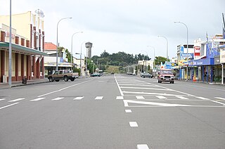
Foxton is a town in the Manawatū-Whanganui region of New Zealand - on the lower west coast of the North Island, in the Horowhenua district, 30 km (19 mi) southwest of Palmerston North and just north of Levin. The town is located close to the banks of the Manawatū River. It is situated on State Highway 1, roughly in the middle between Tongariro National Park and Wellington.

Ferrymead is a suburb south-east of Christchurch, New Zealand. It is the main thoroughfare for reaching the eastern sea suburbs such as Sumner, as well as home to a number of cliff-top residences and businesses along the estuary front. After the 2011 Canterbury earthquake, a number of prominent Christchurch businesses relocated to the Ferrymead area, making it into a secondary business hub.

Lake Te Anau is in the southwestern corner of the South Island of New Zealand. The lake covers an area of 344 km2 (133 sq mi), making it the second-largest lake by surface area in New Zealand and the largest in the South Island. It is the second largest lake in Australasia by fresh water volume. The main body of the lake runs north-south, and is 65 km in length. Three large fiords form arms to the lake on its western flank: North Fiord, Middle Fiord and South Fiord. These are the only inland fiords that New Zealand has, the other 14 are out on the coast. Several small islands lie in the entrance to Middle Fiord, which forks partway along its length into northwest and southwest arms. The surface of the lake is at an altitude of 210 m. It has a maximum depth of 425 m, so much of its bed lies below sea level, with the deepest part of the lake being 215 metres below sea level.

Waikanae is a town on the Kāpiti Coast, 60 km (37 mi) north of the Wellington, New Zealand. The name is a Māori word meaning "waters" (wai) "of the grey mullet".

The Catlins comprise an area in the southeastern corner of the South Island of New Zealand. The area lies between Balclutha and Invercargill, straddling the boundary between the Otago and Southland regions. It includes the South Island's southernmost point, Slope Point.

The Ōreti River is one of the main rivers of Southland, New Zealand, and is 170 kilometres (110 mi) long. The river has been identified as an Important Bird Area by BirdLife International because, for much of its length, it supports breeding colonies of black-billed gulls.

Tairua is a beachside town located on the east coast of the Coromandel Peninsula in the North Island of New Zealand in the Thames-Coromandel District. It is located 150 kilometres east of Auckland and 125 kilometers north of Tauranga. It lies at the mouth of the Tairua River on its north bank and on the small Paku Peninsula. As the 2023 census, the town had a permanent population of 1,630. Tairua is a Māori name which translates literally as tai: tides, rua: two.
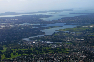
The Tāmaki River or Tāmaki Estuary is mostly an estuarial arm and harbour of the Hauraki Gulf, within the city of Auckland in New Zealand. It extends south for 15 kilometres (9 mi) from its mouth between the suburb of Saint Heliers and the long thin peninsula of Bucklands Beach, which reaches its end at Musick Point. The inlet extends past the suburbs of Glendowie, Wai o Taiki Bay, Point England, Glen Innes, Tāmaki, Panmure, and Ōtāhuhu to the west, and Bucklands Beach, Half Moon Bay, Farm Cove, Sunnyhills and Pakuranga to the east.

The Ōwaka River, until 2019 officially the Owaka River, flows southeastward through The Catlins, an area of the southern South Island of New Zealand. Its total length is 30 kilometres (19 mi), and it shares the estuary of the Catlins River, flowing into the Pacific Ocean at Pounawea, 28 kilometres (17 mi) south of Balclutha. Its source is on the slopes of Mount Rosebery, 12 kilometres (7.5 mi) south of Clinton. The Ōwaka River is located within the Clutha District.

The Catlins River flows southeastward through The Catlins, an area of the southern South Island of New Zealand. Its total length is 42 kilometres (26 mi), and it flows into the Pacific Ocean at the holiday settlement of Pounawea, 28 kilometres (17 mi) south of Balclutha. Its upper estuary is called Catlins Lake, and its lower estuary is shared with the Ōwaka River. The lower estuary is also known at Pounawea Estuary.

The Ōkura River, also known as the Ōkura Estuary, is a river in the north of the Auckland Region in the North Island of New Zealand. The river rises in the low hills to the south of Silverdale and flows into Karepiro Bay on the Hauraki Gulf / Tīkapa Moana. The river is extremely tidal with only a narrow channel being navigable by small craft at low tide. The area is popular for horse riding, riders wait till low tide and then ford the boating channel to ride the estuary and beaches on the northern side.
The Oneone River is a short river of the West Coast Region of New Zealand's South Island. It is located northwest of Harihari, and reaches the Tasman Sea at the estuary of its larger northern neighbour, the Wanganui River.

The Avon River / Ōtākaro, sometimes rendered as the River Avon, flows through the centre of the city of Christchurch, New Zealand, and into the Pacific Ocean via the Avon Heathcote Estuary / Ihutai, which it shares with the Ōpāwaho / Heathcote River.
The Pleasant River is in the Otago region of New Zealand. It rises in hilly forested country near Mount Trotter, west of Palmerston, fed by many small streams. After flowing generally eastward, the river turns south about 2 kilometres (1.2 mi) south of Palmerston, passes the settlement of Wairunga, and enters the sea via an estuary midway between Shag Point and Waikouaiti.

Southshore is an eastern coastal suburb within Christchurch, New Zealand. It is located on a narrow 2.5 km (1.6 mi) long sandspit that runs along the eastern side of the Avon Heathcote Estuary and west of the Pacific Ocean. The suburb is 8 km (5.0 mi) east of the city centre and 5 km (3.1 mi) south of New Brighton's main retail area.
Pleasant Valley is a small locality near the town of Geraldine in the Canterbury Region of the South Island of New Zealand. The area is boarded by the Geraldine Downs to the north and Gapes Valley to the south. The Hae Hae Te Moana River runs through the valley.
Pleasant Flat is an alluvial floodplain of the Haast River in the Haast Pass on New Zealand's South Island. A former stopping place for travellers crossing the pass before the building of the highway, it now has a campsite and picnic shelter. It has a notable view of Mount Hooker to the northeast.
Mahurangi Harbour is a natural harbour in New Zealand. It is located on the north-eastern coast of the Auckland Region near the town of Warkworth, and empties into the Hauraki Gulf.
