Speight's is a brewery located in Dunedin, New Zealand. The brewery is owned by the Japanese-controlled holding company Lion. It is best known for its Gold Medal Ale, one of the best-selling beers in New Zealand. The brewery also gave rise to a chain of Speight's Ale House gastropubs across the country.

The Taieri River is the fourth-longest river in New Zealand and is in Otago in the South Island. Rising in the Lammerlaw Range, it initially flows north, then east around the Rock and Pillar range before turning southeast, reaching the sea 30 kilometres (19 mi) south of Dunedin.
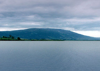
Maungatua, known also as Maukaatua is a prominent ridge in the Taieri Plains in Otago, New Zealand.

The Silverpeaks is an area of rough forest and tussock and scrub covered hill country inland and to the northwest of Dunedin, New Zealand. The area is largely uninhabited; the main indication of human activity is the Taieri Gorge Railway, which preserves the route of the former Otago Central Railway that runs along the steep-sided valley of the Taieri River. Much of the area lies within the Silverpeaks Scenic Reserve.

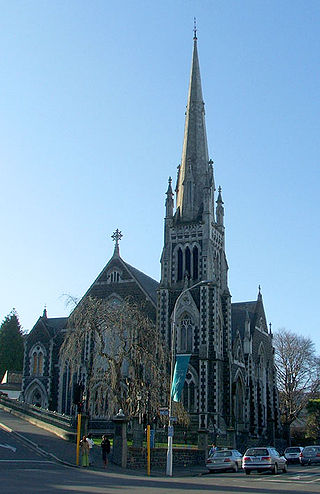
First Church is a prominent church in the New Zealand city of Dunedin. It is located in the heart of the city on Moray Place, 100 metres to the south of the city centre. The church is the city's primary Presbyterian church. The building is regarded as the most impressive of New Zealand's nineteenth-century churches, and is listed by Heritage New Zealand as a Category I structure.

Princes Street is a major street in Dunedin, the second largest city in the South Island of New Zealand. It runs south-southwest for two kilometres from The Octagon in the city centre to the Oval sports ground, close to the city's Southern Cemetery. North of The Octagon, George Street continues the line of Princes Street north-northeast for two and a half kilometres. Princes Street is straight but undulating, skirting the edge of the City Rise to its northwest. The part of the street immediately below The Octagon is the steepest section, as the road traverses an old cutting through Bell Hill.

Moray Place is an octagonal street which surrounds the city centre of Dunedin, Otago, New Zealand. The street is intersected by Stuart Street, Princes Street and George Street. Like many streets in Dunedin, it is named for a street in the Scottish capital Edinburgh.

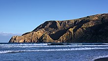
Lawyers Head is a prominent landmark on the coast of Otago, New Zealand. Located within the city of Dunedin, this rocky headland juts into the Pacific Ocean at the eastern end of the city's main beach, Saint Kilda Beach. It is named for the likeness of the cliff face to the profile of a lawyer in traditional legal wig.

Logan Park is a sporting venue in the city of Dunedin, New Zealand. It lies on land reclaimed from the former Lake Logan.
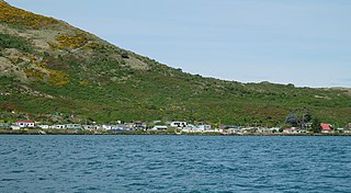
The settlement of Harington Point lies within the boundaries of the city of Dunedin, New Zealand. It is located at the Otago Heads, at the northeastern end of Otago Peninsula, close to the entrance of Otago Harbour. The mouth of the harbour is at its narrowest at Harington Point, only some 400 metres separating the point from the mudflats at Aramoana on the opposing coast.
Flagstaff, known in Māori as Te Whanaupaki, is a prominent hill overlooking the northwest of the city of Dunedin, in New Zealand's South Island. Together with Mount Cargill, which lies to its northeast, it dominates the skyline of the city. Flagstaff lies seven kilometres to the north of Dunedin's city centre.
Knox Church is a notable building in Dunedin, New Zealand. It houses the city's second Presbyterian congregation and is the city's largest church of any denomination.

The Town Belt is a green belt which surrounds the centre of the New Zealand city of Dunedin. Covering a total of over 200 hectares, it extends around three sides of the city's centre at a distance from it of some 1-3 km in a broad 7 km crescent from the Oval at Kensington in the south through the suburbs of Mornington, City Rise, Belleknowes, Roslyn, Maori Hill, Prospect Park, Glenleith, Woodhaugh, The Gardens and Dunedin North and the slopes of Signal Hill. The fourth side of the central city is bounded by the Otago Harbour.

Leith Saddle is a saddle between the sources of the Water of Leith and the Waitati River, approximately halfway between Dunedin's northern suburb of Pine Hill and the outlying settlement of Waitati. The saddle is a strategic point where the Dunedin Northern Motorway, part of State Highway 1 traverses a fragile alpine forest. Proposed road works to straighten a dangerous corner here conflict with conservation values. Water supply pipelines, and popular tramping and cycling routes also converge at the saddle.

Andersons Bay Cemetery is a major cemetery in the New Zealand city of Dunedin. It is located 4 kilometres (2.5 mi) to the southeast of the city centre, on a rocky outcrop which forms the inland part of Lawyers Head, a promontory which juts into the Pacific Ocean. The cemetery is bounded on the western and southern sides by Chisholm Park Golf Links, and to the east by steep slopes which descend to the Tomahawk Lagoon. Despite its name, the cemetery is located in the suburb of Tahuna, which lies immediately to the south of the suburb of Andersons Bay, and almost 1 kilometre (0.62 mi) from the former bay itself, at the head of the Otago Harbour.

Hoopers Inlet is one of two large inlets in the Pacific coast of Otago Peninsula, in the South Island of New Zealand.
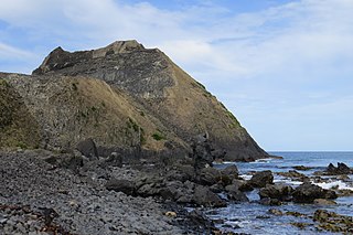
Blackhead is a promontory on the coast of Otago, New Zealand. It lies within the city limits of Dunedin, some 10 kilometres (6.2 mi) southwest of the city centre. The promontory extends some 500 metres into the ocean, and rises to a height of a little over 100 metres (330 ft). Māori names for Blackhead include Te Wai o Tinarau and Makereatu.

Queens Gardens is a roughly triangular area of trees and lawn in central Dunedin, New Zealand.